
Station IM VNDAB - Station B, Vanda, Antarctica
Network: IM - International Miscellaneous Stations
Nearby stations (2 deg radius)
| Station | Name | (Lat, Lon) | Start / End | Elevation |
| VNDAB | Station B, Vanda, Antarctica | (-77.52, 161.85) | 2002-12-06 / 2499-01-01 | 151 m |
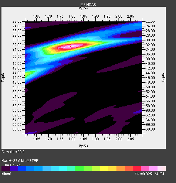
| Crust2 Type: | NB,highly extended crust, 0.5 km ice, 0.5km sediments |
| Thickness Estimate: | 32 km |
| Thickness StdDev: | 1.8 km |
| Vp/Vs Estimate: | 1.79 |
| Vp/Vs StdDev: | 0.03 |
| Vs Estimate: | 3.484 km/s |
| Poisson's Ratio: | 0.27 |
| Peak Value: | 0.03 |
| Assumed Vp: | 6.245 km/s |
| Ps Weight: | 0.33333334 |
| PpPs Weight: | 0.33333334 |
| PsPs Weight: | 0.33333328 |
| Residual Complexity: | 0.519 |
| Nearby stations H: | 30 km +- 4.9 km |
| (2.0 deg) Vp/Vs: | 1.90 +- 0.18 |
20 with match > 90% ( 47.61905 %) and 40 with match > 80% ( 95.2381 %) out of 42.
Download stack as xyz text file.
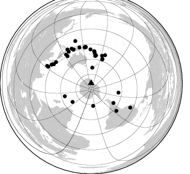
Azimuth Distribution of Events:
Prior Results for this Station
| Study | Thickness | Vp/Vs | Vp | Vs | Poissons Ratio | Extra |
| EARS | 32 km | 1.79 | 6.245 km/s | 3.484 km/s | 0.27 | |
| Crust2.0 | 27 km | 1.78 | 6.245 km/s | 3.51 km/s | 0.27 | NB,highly extended crust, 0.5 km ice, 0.5km sediments |
| Global Maxima | 32 km | 1.79 | 6.245 km/s | 3.484 km/s | 0.27 | amp=0.025124174 |
| Local Maxima 1 | 44 km | 1.60 | 6.245 km/s | 3.903 km/s | 0.18 | amp=0.014704491 |
| Local Maxima 2 | 34 km | 1.77 | 6.245 km/s | 3.518 km/s | 0.27 | amp=0.012474473 |
| Local Maxima 3 | 32 km | 1.75 | 6.245 km/s | 3.579 km/s | 0.26 | amp=0.010831075 |
| Local Maxima 4 | 46 km | 1.60 | 6.245 km/s | 3.903 km/s | 0.18 | amp=0.0068967748 |
| Predicted Arrivals for vertical incidence (zero ray parameter) | |
| Ps | 4.12 SECOND |
| PpPs | 14.53 SECOND |
| PsPs/PpSs | 18.66 SECOND |
Events Processed for this Station
Download zip of receiver functions as SAC
Plot maxima for each earthquake.
Events Used in the Stack
(40 events)| Radial Match | Distance | Baz | FERegion | Time | Lat/Lon | Depth | Magnitude |
| 98.55623 | 67.0 deg | 358.843 deg | Solomon Islands | 2003/01/20 08:43:06 GMT | (-10.5, 160.8) | 33 km | 6.7 MB, 7.8 MS, 7.3 MW, 7.2 MW |
| 98.40864 | 55.4 deg | 8.815 deg | Southeast Of Loyalty Islands | 2004/01/03 16:23:21 GMT | (-22.3, 169.7) | 22 km | 6.4 MB, 7.1 MS, 7.1 MW, 6.8 MW |
| 98.240326 | 73.1 deg | 351.266 deg | New Ireland Region, P.N.G. | 2005/09/09 07:26:43 GMT | (-4.5, 153.5) | 90 km | 6.3 MB, 7.7 MW, 7.5 MW |
| 97.0867 | 63.3 deg | 5.867 deg | Vanuatu Islands | 2005/02/08 14:48:21 GMT | (-14.3, 167.3) | 206 km | 6.1 MB, 6.8 MW, 6.7 MW |
| 96.43172 | 85.0 deg | 296.169 deg | Northern Sumatra, Indonesia | 2005/05/14 05:05:18 GMT | (0.6, 98.5) | 34 km | 6.4 MB, 6.8 MS, 6.8 MW, 6.8 MW |
| 96.418236 | 72.2 deg | 349.527 deg | New Britain Region, P.N.G. | 2005/09/29 15:50:24 GMT | (-5.4, 151.8) | 25 km | 5.9 MB, 6.6 MS, 6.7 MW, 6.5 MW |
| 96.154106 | 75.2 deg | 332.627 deg | Irian Jaya Region, Indonesia | 2004/11/26 02:25:03 GMT | (-3.6, 135.4) | 10 km | 6.2 MB, 7.2 MS, 7.1 MW, 7.0 MW |
| 94.884705 | 31.0 deg | 3.839 deg | Off W. Coast Of S. Island, N.Z. | 2004/11/22 20:26:23 GMT | (-46.7, 164.7) | 10 km | 6.4 MB, 7.1 MS, 7.1 MW, 7.0 MW |
| 94.66911 | 91.0 deg | 122.18 deg | Northern Peru | 2005/09/26 01:55:37 GMT | (-5.7, -76.4) | 115 km | 6.7 MB, 7.5 MW, 7.5 MW |
| 92.88483 | 72.9 deg | 351.015 deg | New Ireland Region, P.N.G. | 2003/03/11 07:27:32 GMT | (-4.7, 153.2) | 40 km | 6.0 MB, 6.8 MS, 6.8 MW, 6.6 MW |
| 92.789055 | 86.5 deg | 295.056 deg | Northern Sumatra, Indonesia | 2005/07/05 01:52:02 GMT | (1.8, 97.1) | 21 km | 6.2 MB, 6.8 MS, 6.7 MW, 6.6 MW |
| 92.66047 | 63.5 deg | 5.16 deg | Vanuatu Islands | 2004/10/20 18:32:24 GMT | (-14.0, 166.6) | 60 km | 5.6 MB, 5.9 MS, 6.1 MW, 6.0 MW |
| 92.60919 | 45.6 deg | 175.012 deg | South Sandwich Islands Region | 2004/10/26 22:53:07 GMT | (-57.1, -24.7) | 10 km | 5.6 MB, 6.3 MS, 6.4 MW, 6.2 MW |
| 91.78041 | 55.8 deg | 9.845 deg | Southeast Of Loyalty Islands | 2005/04/11 17:08:53 GMT | (-22.0, 170.6) | 68 km | 6.0 MB, 6.8 MW, 6.8 MW |
| 90.81087 | 78.6 deg | 330.601 deg | Irian Jaya Region, Indonesia | 2004/07/28 03:56:28 GMT | (-0.4, 133.1) | 13 km | 6.0 MB, 6.3 MS, 6.5 MW, 6.4 MW |
| 90.75593 | 72.3 deg | 351.476 deg | New Ireland Region, P.N.G. | 2003/01/10 13:11:56 GMT | (-5.3, 153.7) | 72 km | 5.9 MB, 6.7 MW, 6.6 MW |
| 90.70464 | 55.3 deg | 8.871 deg | Southeast Of Loyalty Islands | 2004/01/03 08:07:34 GMT | (-22.4, 169.7) | 10 km | 5.6 MB, 5.9 MS, 5.9 MW, 5.8 MW |
| 90.653015 | 89.1 deg | 339.38 deg | W. Caroline Islands, Micronesia | 2005/01/16 20:17:52 GMT | (10.9, 140.8) | 25 km | 6.3 MB, 6.7 MS, 6.6 MW, 6.6 MW |
| 90.6037 | 76.6 deg | 324.498 deg | Seram, Indonesia | 2004/01/28 22:15:30 GMT | (-3.1, 127.4) | 17 km | 6.0 MB, 6.5 MS, 6.7 MW, 6.6 MW |
| 90.53632 | 74.9 deg | 332.195 deg | Irian Jaya Region, Indonesia | 2004/02/07 02:42:35 GMT | (-4.0, 135.0) | 10 km | 6.2 MB, 7.5 MS, 7.3 MW, 7.3 MW |
| 89.53404 | 58.3 deg | 243.6 deg | South Indian Ocean | 2004/01/11 04:32:47 GMT | (-36.7, 53.4) | 5.3 km | 6.1 MB, 6.1 MS, 6.2 MW, 6.2 MW |
| 89.50966 | 81.0 deg | 301.053 deg | Southern Sumatra, Indonesia | 2004/07/25 14:35:19 GMT | (-2.4, 104.0) | 582 km | 6.8 MB, 7.3 MW, 7.3 MW |
| 89.30437 | 82.6 deg | 296.867 deg | Southern Sumatra, Indonesia | 2005/04/10 10:29:11 GMT | (-1.6, 99.6) | 19 km | 6.4 MB, 6.7 MS, 6.7 MW, 6.6 MW |
| 88.525566 | 93.4 deg | 291.496 deg | Nicobar Islands, India Region | 2005/07/24 15:42:06 GMT | (7.9, 92.2) | 16 km | 6.6 MB, 7.5 MS, 7.3 MW, 7.2 MW |
| 88.40534 | 71.1 deg | 318.945 deg | Savu Sea | 2004/04/23 01:50:30 GMT | (-9.4, 122.8) | 66 km | 6.5 MB, 6.7 MW, 6.7 MW |
| 87.96573 | 58.3 deg | 21.577 deg | Fiji Islands Region | 2004/11/17 21:09:13 GMT | (-20.1, -178.7) | 623 km | 5.9 MB, 6.6 MW, 6.5 MW |
| 86.474464 | 60.1 deg | 6.549 deg | Vanuatu Islands | 2005/09/25 12:55:46 GMT | (-17.5, 167.8) | 30 km | 5.7 MB, 5.9 MS, 6.2 MW, 6.2 MW |
| 85.301796 | 61.9 deg | 26.155 deg | Tonga Islands | 2004/01/25 11:43:11 GMT | (-16.8, -174.2) | 130 km | 6.4 MB, 6.7 MW, 6.7 MW |
| 84.86666 | 59.2 deg | 131.851 deg | Near Coast Of Central Chile | 2004/06/15 11:16:31 GMT | (-38.9, -73.2) | 38 km | 5.7 MB, 5.4 MS, 6.1 MW, 5.9 MW |
| 84.4968 | 74.3 deg | 137.9 deg | Salta Province, Argentina | 2005/03/21 12:23:54 GMT | (-25.0, -63.5) | 579 km | 6.1 MB, 6.9 MW, 6.9 MW |
| 84.479866 | 54.6 deg | 8.328 deg | Southeast Of Loyalty Islands | 2005/02/10 16:53:19 GMT | (-23.1, 169.2) | 9.0 km | 6.0 MB, 5.7 MS, 6.4 MW, 6.2 MW |
| 83.96893 | 72.0 deg | 351.352 deg | New Ireland Region, P.N.G. | 2005/09/16 00:31:42 GMT | (-5.6, 153.6) | 11 km | 6.1 MB, 5.4 MS, 5.7 MW, 5.6 MW |
| 83.75764 | 51.6 deg | 25.035 deg | Kermadec Islands Region | 2005/07/11 23:06:01 GMT | (-27.0, -176.3) | 10 km | 5.5 MB, 5.7 MS, 6.0 MW, 5.9 MW |
| 83.37581 | 81.3 deg | 325.005 deg | Halmahera, Indonesia | 2003/03/10 02:09:37 GMT | (1.7, 127.3) | 94 km | 6.2 MB, 6.4 MW, 6.4 MW |
| 82.2019 | 74.4 deg | 341.732 deg | Near N Coast Of New Guinea, P.N.G. | 2003/02/12 22:33:30 GMT | (-3.7, 144.2) | 10 km | 6.0 MB, 6.1 MS, 6.2 MW, 6.2 MW |
| 82.00668 | 57.2 deg | 109.257 deg | West Chile Rise | 2005/07/10 04:46:31 GMT | (-36.3, -97.3) | 10 km | 5.3 MB, 5.7 MS, 6.1 MW, 6.0 MW |
| 81.45643 | 52.4 deg | 224.716 deg | Prince Edward Islands Region | 2003/01/27 17:56:25 GMT | (-46.0, 35.1) | 10 km | 5.6 MB, 6.3 MS, 6.5 MW, 6.4 MW |
| 81.20101 | 90.6 deg | 291.035 deg | Off W Coast Of Northern Sumatra | 2005/01/01 06:25:44 GMT | (5.1, 92.3) | 12 km | 6.0 MB, 6.7 MS, 6.6 MW, 6.5 MW |
| 80.411476 | 74.9 deg | 318.786 deg | Sulawesi, Indonesia | 2005/02/19 00:04:43 GMT | (-5.6, 122.1) | 10 km | 6.3 MB, 6.3 MS, 6.5 MW, 6.4 MW |
| 80.24146 | 53.1 deg | 24.872 deg | South Of Fiji Islands | 2005/01/16 08:25:04 GMT | (-25.5, -176.3) | 16 km | 6.0 MB, 6.1 MS, 6.2 MW, 6.1 MW |
Losers
(2 events)| Radial Match | Distance | Baz | FERegion | Time | Lat/Lon | Depth | Magnitude | Reason |
| 85.1204 | 60.7 deg | 21.44 deg | Fiji Islands Region | 2004/07/15 04:27:12 GMT | (-17.6, -178.6) | 560 km | 5.5 MB | |
| 71.884315 | 54.9 deg | 232.133 deg | Prince Edward Islands Region | 2005/07/04 11:36:05 GMT | (-42.3, 42.4) | 10 km | 5.7 MB, 5.7 MS, 6.3 MW, 6.1 MW |
