You are here: Home > Network List > AK - Alaska Regional Network Stations List
> Station D22K Ayikyak River, AK, USA > Earthquake Result Viewer
D22K Ayikyak River, AK, USA - Earthquake Result Viewer
| Earthquake location: |
Vanuatu Islands |
| Earthquake latitude/longitude: |
-13.7/167.5 |
| Earthquake time(UTC): |
2021/08/31 (243) 13:26:58 GMT |
| Earthquake Depth: |
10 km |
| Earthquake Magnitude: |
5.3 Mww |
| Earthquake Catalog/Contributor: |
NEIC PDE/us |
|
| Network: |
AK Alaska Regional Network |
| Station: |
D22K Ayikyak River, AK, USA |
| Lat/Lon: |
68.88 N/152.68 W |
| Elevation: |
532 m |
|
| Distance: |
87.1 deg |
| Az: |
13.437 deg |
| Baz: |
218.54 deg |
| Ray Param: |
0.04357818 |
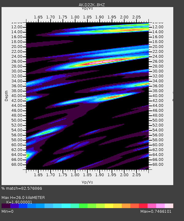
| Estimated Moho Depth: |
26.0 km |
| Estimated Crust Vp/Vs: |
1.91 |
| Assumed Crust Vp: |
6.221 km/s |
| Estimated Crust Vs: |
3.257 km/s |
| Estimated Crust Poisson's Ratio: |
0.31 |
|
| Radial Match: |
82.576866 % |
| Radial Bump: |
400 |
| Transverse Match: |
70.94372 % |
| Transverse Bump: |
400 |
| SOD ConfigId: |
25131211 |
| Insert Time: |
2021-09-14 13:28:12.832 +0000 |
| GWidth: |
2.5 |
| Max Bumps: |
400 |
| Tol: |
0.001 |
|

Signal To Noise
| Channel | StoN | STA | LTA |
| AK:D22K: :BHZ:20210831T13:39:12.519987Z | 3.094023 | 1.4470373E-7 | 4.67688E-8 |
| AK:D22K: :BHN:20210831T13:39:12.519987Z | 1.5665834 | 7.8531926E-8 | 5.0129422E-8 |
| AK:D22K: :BHE:20210831T13:39:12.519987Z | 1.4409716 | 4.0109E-8 | 2.7834693E-8 |
| Arrivals |
| Ps | 3.9 SECOND |
| PpPs | 12 SECOND |
| PsPs/PpSs | 16 SECOND |


