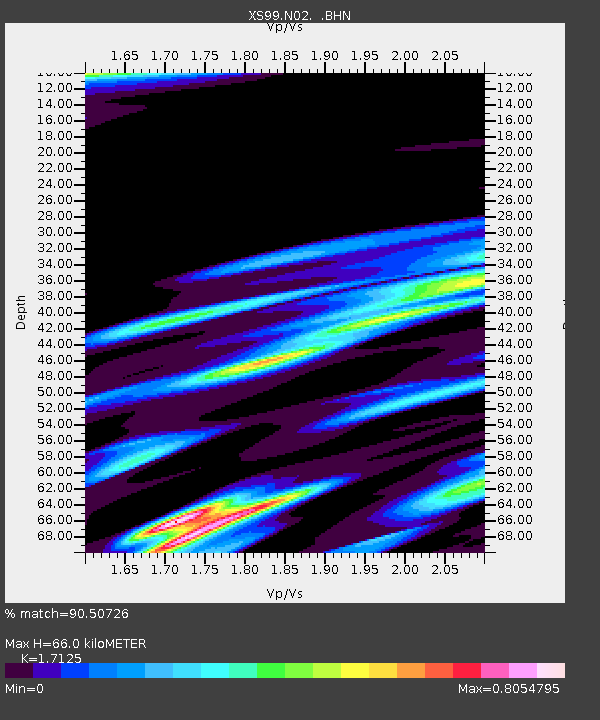
N02 XS.N02 - Earthquake Result Viewer

Earthquake location: Near Coast Of Chiapas, Mexico
Earthquake latitude/longitude: 15.0/-92.4
Earthquake time(UTC): 2000/03/12 (072) 22:21:30 GMT
Earthquake Depth: 62 km
Earthquake Magnitude: 5.5 MB, 5.8 MS, 6.3 MW, 5.4 MD
Earthquake Catalog/Contributor: WHDF/NEIC
Network: XS Montana BB Array
Station: N02 XS.N02
Lat/Lon: 46.25 N/109.21 W
Elevation: 1800 m
Distance: 34.2 deg
Az: 339.145 deg
Baz: 150.276 deg
Ray Param: 0.07769617
Estimated Moho Depth: 66.0 km
Estimated Crust Vp/Vs: 1.71
Assumed Crust Vp: 6.518 km/s
Estimated Crust Vs: 3.806 km/s
Estimated Crust Poisson's Ratio: 0.24
Radial Match: 90.50726 %
Radial Bump: 347
Transverse Match: 70.07273 %
Transverse Bump: 400
SOD ConfigId: 20082
Insert Time: 2010-03-09 12:25:34.550 +0000
GWidth: 2.5
Max Bumps: 400
Tol: 0.001

Signal To Noise

ChannelStoNSTALTA
XS:N02: :BHN:20000312T22:27:39.748015Z6.4258321.8474115E-62.874976E-7
XS:N02: :BHE:20000312T22:27:39.748015Z2.81325171.0263335E-63.648211E-7
XS:N02: :BHZ:20000312T22:27:39.748015Z15.5710223.6035037E-62.3142371E-7
Arrivals
Ps7.8 SECOND
PpPs25 SECOND
PsPs/PpSs33 SECOND