
Station XS N02 - XS.N02
Network: XS99 - Montana BB Array
Nearby stations (2 deg radius)
| Station | Name | (Lat, Lon) | Start / End | Elevation |
| N02 | XS.N02 | (46.25, -109.21) | 1999-08-21 / 2000-08-25 | 1800 m |
| Crust2 Type: | H6,early/mid Proter., U.S., 1.5 km seds. |
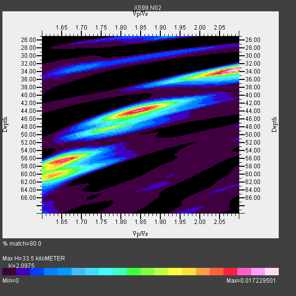
| Thickness Estimate: | 34 km |
| Thickness StdDev: | 11 km |
| Vp/Vs Estimate: | 2.10 |
| Vp/Vs StdDev: | 0.20 |
| Vs Estimate: | 3.108 km/s |
| Poisson's Ratio: | 0.35 |
| Peak Value: | 0.02 |
| Assumed Vp: | 6.518 km/s |
| Ps Weight: | 0.33333334 |
| PpPs Weight: | 0.33333334 |
| PsPs Weight: | 0.33333328 |
| Residual Complexity: | 0.797 |
| Nearby stations H: | +- |
| (2.0 deg) Vp/Vs: | +- |
7 with match > 90% ( 53.846153 %) and 13 with match > 80% ( 100.0 %) out of 13.
Download stack as xyz text file.
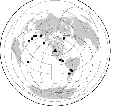
Azimuth Distribution of Events:
Prior Results for this Station
| Study | Thickness | Vp/Vs | Vp | Vs | Poissons Ratio | Extra |
| EARS | 34 km | 2.10 | 6.518 km/s | 3.108 km/s | 0.35 | |
| Crust2.0 | 52 km | 1.78 | 6.518 km/s | 3.665 km/s | 0.27 | H6,early/mid Proter., U.S., 1.5 km seds. |
| Global Maxima | 34 km | 2.10 | 6.518 km/s | 3.108 km/s | 0.35 | amp=0.017229501 |
| Local Maxima 1 | 56 km | 1.67 | 6.518 km/s | 3.903 km/s | 0.22 | amp=0.013151263 |
| Local Maxima 2 | 44 km | 1.83 | 6.518 km/s | 3.557 km/s | 0.29 | amp=0.011343242 |
| Local Maxima 3 | 60 km | 1.64 | 6.518 km/s | 3.975 km/s | 0.20 | amp=0.009129501 |
| Local Maxima 4 | 48 km | 1.77 | 6.518 km/s | 3.683 km/s | 0.27 | amp=0.0053272606 |
| Predicted Arrivals for vertical incidence (zero ray parameter) | |
| Ps | 5.64 SECOND |
| PpPs | 15.92 SECOND |
| PsPs/PpSs | 21.56 SECOND |
Events Processed for this Station
Download zip of receiver functions as SAC
Plot maxima for each earthquake.
Events Used in the Stack
(13 events)| Radial Match | Distance | Baz | FERegion | Time | Lat/Lon | Depth | Magnitude |
| 95.73293 | 85.2 deg | 297.353 deg | Volcano Islands, Japan Region | 2000/03/28 11:00:22 GMT | (22.3, 143.7) | 126 km | 6.8 MB, 7.6 MS, 7.6 MW, 7.6 MW |
| 95.21672 | 66.8 deg | 316.982 deg | Sakhalin, Russia | 2000/08/04 21:13:02 GMT | (48.8, 142.2) | 10 km | 6.3 MB, 7.1 MS, 6.8 MW, 6.7 MW |
| 94.53384 | 79.5 deg | 140.691 deg | Jujuy Province, Argentina | 2000/05/12 18:43:18 GMT | (-23.5, -66.5) | 225 km | 6.2 MB, 7.2 MW, 7.1 MW |
| 94.05448 | 49.1 deg | 35.674 deg | Iceland | 2000/06/21 00:51:46 GMT | (64.0, -20.8) | 10 km | 6.1 MB, 6.6 MS, 6.5 MW, 6.4 MW |
| 92.26774 | 42.0 deg | 143.356 deg | Off Coast Of Costa Rica | 2000/07/21 01:53:35 GMT | (9.4, -85.3) | 33 km | 5.9 MB, 6.1 MS, 6.4 MW, 5.7 ML |
| 91.866486 | 82.8 deg | 304.502 deg | Bonin Islands, Japan Region | 2000/08/06 07:27:12 GMT | (28.9, 139.6) | 395 km | 6.3 MB, 7.3 MW, 7.3 MW |
| 90.50726 | 34.2 deg | 150.276 deg | Near Coast Of Chiapas, Mexico | 2000/03/12 22:21:30 GMT | (15.0, -92.4) | 62 km | 5.5 MB, 5.8 MS, 6.3 MW, 5.4 MD |
| 89.21793 | 79.1 deg | 307.955 deg | Southeast Of Honshu, Japan | 2000/07/30 12:25:45 GMT | (33.9, 139.4) | 10 km | 6.0 MB, 6.5 MS, 6.5 MW, 6.5 MW |
| 87.71537 | 85.2 deg | 140.297 deg | Santiago Del Estero Prov., Arg. | 2000/04/23 09:27:23 GMT | (-28.3, -63.0) | 608 km | 6.6 MB, 7.0 MW, 7.0 MW |
| 87.191864 | 87.2 deg | 148.298 deg | Chile-Argentina Border Region | 2000/06/16 07:55:35 GMT | (-33.9, -70.1) | 120 km | 6.2 MB, 6.5 MW, 6.1 MD |
| 84.82082 | 95.3 deg | 247.341 deg | Vanuatu Islands Region | 2000/02/25 01:43:58 GMT | (-19.5, 173.8) | 33 km | 6.1 MB, 7.1 MS, 7.1 MW, 7.0 MW |
| 83.206604 | 91.6 deg | 290.613 deg | Mariana Islands | 2000/06/29 07:59:06 GMT | (13.0, 144.5) | 52 km | 5.5 MB, 5.5 MS, 5.9 MW, 5.8 MW |
| 82.04817 | 44.1 deg | 302.969 deg | Andreanof Islands, Aleutian Is. | 2000/04/21 04:35:17 GMT | (51.4, -178.1) | 33 km | 6.0 MB, 5.7 MS, 6.2 ML, 6.0 MW |
Losers
(0 events)| Radial Match | Distance | Baz | FERegion | Time | Lat/Lon | Depth | Magnitude | Reason |
