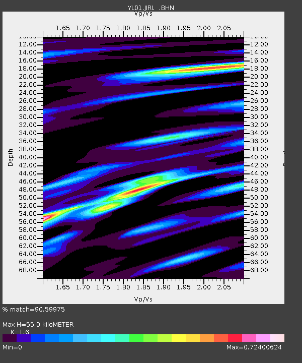
JIRI YL.JIRI - Earthquake Result Viewer
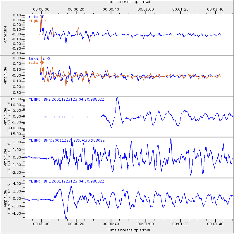
Earthquake location: Solomon Islands
Earthquake latitude/longitude: -9.6/159.5
Earthquake time(UTC): 2001/12/23 (357) 22:52:54 GMT
Earthquake Depth: 16 km
Earthquake Magnitude: 6.2 MB, 7.0 MS, 6.8 MW, 6.7 MW
Earthquake Catalog/Contributor: WHDF/NEIC
Network: YL Himalayan Nepal Tibet Experiment
Station: JIRI YL.JIRI
Lat/Lon: 27.63 N/86.23 E
Elevation: 1866 m
Distance: 79.9 deg
Az: 300.336 deg
Baz: 106.397 deg
Ray Param: 0.048613727
Estimated Moho Depth: 55.0 km
Estimated Crust Vp/Vs: 1.60
Assumed Crust Vp: 6.236 km/s
Estimated Crust Vs: 3.897 km/s
Estimated Crust Poisson's Ratio: 0.18
Radial Match: 90.59975 %
Radial Bump: 400
Transverse Match: 87.20906 %
Transverse Bump: 400
SOD ConfigId: 16820
Insert Time: 2010-02-26 15:57:27.400 +0000
GWidth: 2.5
Max Bumps: 400
Tol: 0.001

Signal To Noise

ChannelStoNSTALTA
YL:JIRI: :BHN:20011223T23:04:30.98802Z0.8336331.3631119E-71.6351461E-7
YL:JIRI: :BHE:20011223T23:04:30.98802Z0.915075541.1399026E-71.2456924E-7
YL:JIRI: :BHZ:20011223T23:04:30.98802Z2.52292851.6073133E-76.370824E-8
Arrivals
Ps5.5 SECOND
PpPs22 SECOND
PsPs/PpSs28 SECOND