
Station YL JIRI - YL.JIRI
Network: YL01 - Himalayan Nepal Tibet Experiment
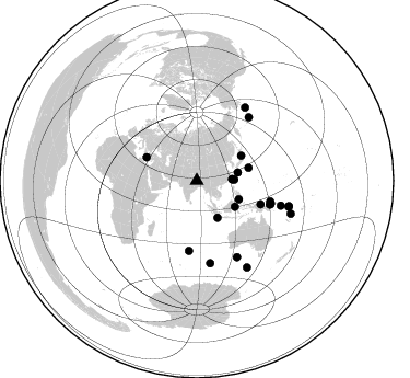
Nearby stations (2 deg radius)
| Station | Name | (Lat, Lon) | Start / End | Elevation |
| JIRI | YL.JIRI | (27.63, 86.23) | 2001-09-07 / 2003-01-01 | 1866 m |
| Crust2 Type: | P7,orogen/50km, Urals, Tethian Orogen, 3 km seds. |
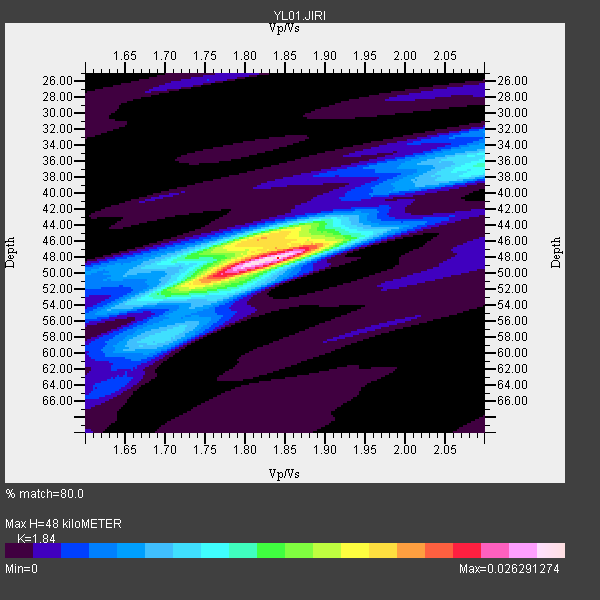
| Thickness Estimate: | 48 km |
| Thickness StdDev: | 1.7 km |
| Vp/Vs Estimate: | 1.84 |
| Vp/Vs StdDev: | 0.04 |
| Vs Estimate: | 3.389 km/s |
| Poisson's Ratio: | 0.29 |
| Peak Value: | 0.03 |
| Assumed Vp: | 6.236 km/s |
| Ps Weight: | 0.33333334 |
| PpPs Weight: | 0.33333334 |
| PsPs Weight: | 0.33333328 |
| Residual Complexity: | 0.633 |
| Nearby stations H: | +- |
| (2.0 deg) Vp/Vs: | +- |
10 with match > 90% ( 27.027027 %) and 25 with match > 80% ( 67.567566 %) out of 37.
Download stack as xyz text file.
Azimuth Distribution of Events:
Prior Results for this Station
| Study | Thickness | Vp/Vs | Vp | Vs | Poissons Ratio | Extra |
| EARS | 48 km | 1.84 | 6.236 km/s | 3.389 km/s | 0.29 | |
| Crust2.0 | 53 km | 1.76 | 6.236 km/s | 3.536 km/s | 0.26 | P7,orogen/50km, Urals, Tethian Orogen, 3 km seds. |
| Global Maxima | 48 km | 1.84 | 6.236 km/s | 3.389 km/s | 0.29 | amp=0.026291274 |
| Local Maxima 1 | 46 km | 1.81 | 6.236 km/s | 3.445 km/s | 0.28 | amp=0.017063575 |
| Local Maxima 2 | 51 km | 1.76 | 6.236 km/s | 3.533 km/s | 0.26 | amp=0.011535807 |
| Local Maxima 3 | 36 km | 2.10 | 6.236 km/s | 2.973 km/s | 0.35 | amp=0.009560984 |
| Local Maxima 4 | 46 km | 1.89 | 6.236 km/s | 3.291 km/s | 0.31 | amp=0.007413718 |
| Predicted Arrivals for vertical incidence (zero ray parameter) | |
| Ps | 6.47 SECOND |
| PpPs | 21.86 SECOND |
| PsPs/PpSs | 28.33 SECOND |
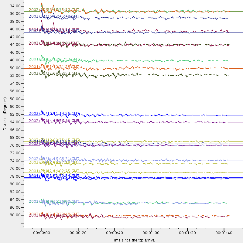
Events Processed for this Station
Download zip of receiver functions as SAC
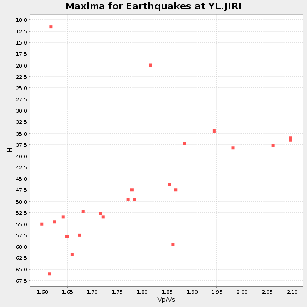
Plot maxima for each earthquake.
Events Used in the Stack
(25 events)| Radial Match | Distance | Baz | FERegion | Time | Lat/Lon | Depth | Magnitude |
| 95.37957 | 70.1 deg | 108.104 deg | New Britain Region, P.N.G. | 2001/10/31 09:10:20 GMT | (-5.9, 150.2) | 33 km | 5.9 MB, 6.9 MS, 6.9 MW, 6.9 MW |
| 94.561554 | 80.3 deg | 33.725 deg | South Of Alaska | 2002/05/25 05:36:31 GMT | (53.8, -161.1) | 33 km | 5.5 MB, 6.1 MS, 6.5 MW, 6.4 MW |
| 93.3051 | 90.9 deg | 109.315 deg | Vanuatu Islands | 2002/01/02 17:22:48 GMT | (-17.6, 167.9) | 21 km | 6.3 MB, 7.5 MS, 7.3 MW, 7.1 MW |
| 92.66637 | 78.5 deg | 152.162 deg | South Of Australia | 2001/12/12 14:02:35 GMT | (-42.8, 124.7) | 10 km | 6.5 MB, 6.7 MS, 7.1 MW, 7.0 MW |
| 91.73855 | 62.2 deg | 110.225 deg | Near N Coast Of New Guinea, P.N.G. | 2002/01/10 11:14:56 GMT | (-3.2, 142.4) | 11 km | 6.0 MB, 6.6 MS, 6.7 MW, 6.6 MW |
| 91.389854 | 38.1 deg | 78.632 deg | Ryukyu Islands, Japan | 2001/12/08 20:29:34 GMT | (28.3, 129.6) | 33 km | 5.7 MB, 5.7 MS, 6.2 MW, 6.1 MW |
| 91.147835 | 34.4 deg | 88.497 deg | Southwestern Ryukyu Isl., Japan | 2002/03/26 03:45:48 GMT | (23.3, 124.1) | 33 km | 5.8 MB, 6.6 MS, 6.4 MW, 6.4 MW |
| 90.59975 | 79.9 deg | 106.397 deg | Solomon Islands | 2001/12/23 22:52:54 GMT | (-9.6, 159.5) | 16 km | 6.2 MB, 7.0 MS, 6.8 MW, 6.7 MW |
| 90.288795 | 38.5 deg | 150.581 deg | Sunda Strait, Indonesia | 2002/06/27 05:50:35 GMT | (-7.0, 104.2) | 11 km | 6.0 MB, 6.9 MS, 6.6 MW, 6.5 MW |
| 90.03881 | 32.4 deg | 87.658 deg | Taiwan Region | 2002/03/31 06:52:50 GMT | (24.3, 122.2) | 33 km | 6.4 MB, 7.4 MS, 7.1 MW, 7.1 MW |
| 89.3916 | 64.2 deg | 186.528 deg | Mid-Indian Ridge | 2002/05/14 16:56:10 GMT | (-36.5, 78.9) | 10 km | 5.6 MB, 6.1 MS, 6.3 MW, 6.1 MW |
| 88.12041 | 46.6 deg | 60.728 deg | Eastern Honshu, Japan | 2001/12/02 13:01:53 GMT | (39.4, 141.1) | 124 km | 6.1 MB, 6.5 MW, 6.5 MW |
| 87.46738 | 87.2 deg | 105.636 deg | Santa Cruz Islands | 2002/06/17 21:26:22 GMT | (-12.6, 166.4) | 33 km | 6.0 MB, 6.7 MS, 6.7 MW, 6.6 MW |
| 87.42371 | 91.2 deg | 149.717 deg | South Of Australia | 2002/04/08 03:48:55 GMT | (-51.1, 139.3) | 10 km | 5.6 MB, 6.1 MS, 6.2 MW, 6.2 MW |
| 85.403854 | 69.7 deg | 105.696 deg | New Ireland Region, P.N.G. | 2002/02/19 00:35:45 GMT | (-3.7, 151.0) | 10 km | 5.9 MB, 6.0 MS, 6.1 MW, 6.1 MW |
| 83.497345 | 42.0 deg | 113.698 deg | Mindanao, Philippines | 2002/03/05 21:16:09 GMT | (6.0, 124.2) | 31 km | 6.3 MB, 7.2 MS, 7.5 MW, 7.2 MW |
| 83.22698 | 50.7 deg | 294.985 deg | Crete, Greece | 2002/01/22 04:53:52 GMT | (35.8, 26.6) | 88 km | 6.2 MB, 6.3 MW, 6.2 MW |
| 82.840096 | 70.7 deg | 107.011 deg | New Britain Region, P.N.G. | 2002/02/05 13:27:24 GMT | (-5.3, 151.2) | 39 km | 5.8 MB, 6.3 MS, 6.6 MW, 6.6 MW |
| 82.63309 | 48.8 deg | 76.045 deg | Bonin Islands, Japan Region | 2001/12/23 10:21:28 GMT | (27.9, 141.8) | 35 km | 5.7 MB, 5.6 MS, 5.9 MW, 5.8 MW |
| 81.86678 | 75.1 deg | 39.438 deg | Andreanof Islands, Aleutian Is. | 2002/03/14 16:08:31 GMT | (51.5, -173.1) | 33 km | 5.5 MB, 5.4 MS, 5.9 MW, 5.6 MW |
| 81.446785 | 87.3 deg | 105.402 deg | Santa Cruz Islands | 2002/06/29 02:39:00 GMT | (-12.4, 166.5) | 33 km | 5.9 MB, 5.9 MS, 6.2 MW, 6.1 MW |
| 80.98722 | 70.7 deg | 107.381 deg | New Britain Region, P.N.G. | 2002/01/13 14:10:56 GMT | (-5.7, 151.1) | 44 km | 5.9 MB, 6.4 MS, 6.3 MW, 6.3 MW |
| 80.561195 | 32.6 deg | 88.001 deg | Taiwan Region | 2002/05/28 16:45:17 GMT | (24.1, 122.3) | 33 km | 5.8 MB, 5.9 MS, 6.0 MW, 6.0 MW |
| 80.422 | 42.1 deg | 124.171 deg | Minahassa Peninsula, Sulawesi | 2002/06/16 00:00:25 GMT | (0.5, 119.9) | 35 km | 5.7 MB, 5.5 MS, 5.9 MW, 5.8 MW |
| 80.30414 | 76.1 deg | 170.654 deg | Southeast Indian Ridge | 2002/06/13 01:27:19 GMT | (-47.8, 99.8) | 10 km | 5.5 MB, 6.6 MS, 6.6 MW, 6.5 MW |
Losers
(12 events)| Radial Match | Distance | Baz | FERegion | Time | Lat/Lon | Depth | Magnitude | Reason |
| 82.04142 | 52.4 deg | 296.405 deg | Southern Greece | 2002/05/21 20:53:29 GMT | (36.6, 24.3) | 97 km | 5.4 MB, 5.6 MD | |
| 77.51856 | 39.0 deg | 53.702 deg | E. Russia-N.E. China Border Reg. | 2002/06/28 17:19:30 GMT | (43.8, 130.7) | 566 km | 6.7 MB, 7.3 MW, 7.3 MW | |
| 75.98802 | 47.1 deg | 76.988 deg | Bonin Islands, Japan Region | 2002/06/03 09:15:00 GMT | (27.6, 139.8) | 489 km | 5.0 MB, 5.9 MW, 5.9 MW | |
| 72.54209 | 59.2 deg | 41.702 deg | Near East Coast Of Kamchatka | 2002/05/08 19:45:18 GMT | (53.8, 160.8) | 39 km | 5.8 MB, 5.4 MS, 5.9 MW, 5.8 MW | |
| 70.845184 | 53.6 deg | 96.807 deg | W. Caroline Islands, Micronesia | 2002/06/10 22:48:36 GMT | (11.0, 140.7) | 33 km | 5.9 MB, 5.9 MS, 6.1 MW, 6.0 MW | |
| 68.90782 | 33.1 deg | 97.157 deg | Philippine Islands Region | 2002/05/13 19:54:43 GMT | (19.1, 121.2) | 33 km | 5.5 MW, 5.4 MB | |
| 66.27202 | 33.7 deg | 149.576 deg | Southern Sumatra, Indonesia | 2002/06/16 18:31:10 GMT | (-2.3, 102.6) | 232 km | 5.8 MW, 5.4 MB, 5.7 MW | |
| 62.116734 | 33.1 deg | 97.172 deg | Philippine Islands Region | 2002/05/13 19:57:22 GMT | (19.1, 121.2) | 33 km | 5.6 MB, 5.3 MS, 5.8 MW | |
| 56.855785 | 50.5 deg | 53.816 deg | Kuril Islands | 2002/05/21 20:04:16 GMT | (44.4, 146.6) | 150 km | 5.5 MB, 5.5 MW, 5.5 MW | |
| 56.31876 | 47.2 deg | 114.244 deg | Halmahera, Indonesia | 2002/05/09 23:41:30 GMT | (2.6, 128.3) | 173 km | 5.7 MB, 5.6 MW, 5.5 MW | |
| 52.005047 | 48.6 deg | 119.263 deg | Halmahera, Indonesia | 2002/05/12 23:12:52 GMT | (-1.1, 127.1) | 33 km | 5.7 MB, 5.6 MS, 5.9 MW, 5.7 MW | |
| 46.90285 | 46.9 deg | 115.997 deg | Halmahera, Indonesia | 2002/05/26 00:10:21 GMT | (1.8, 127.2) | 109 km | 5.8 MB, 5.9 MW, 5.8 MW |
