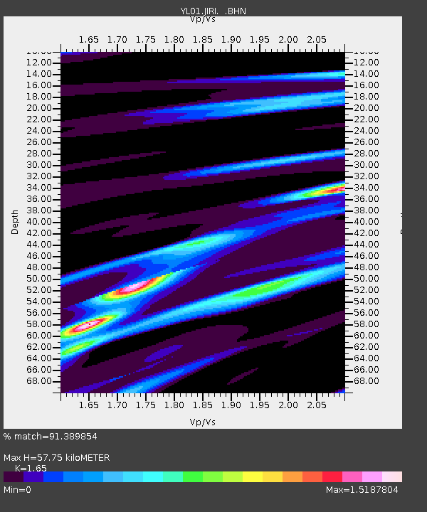
JIRI YL.JIRI - Earthquake Result Viewer

Earthquake location: Ryukyu Islands, Japan
Earthquake latitude/longitude: 28.3/129.6
Earthquake time(UTC): 2001/12/08 (342) 20:29:34 GMT
Earthquake Depth: 33 km
Earthquake Magnitude: 5.7 MB, 5.7 MS, 6.2 MW, 6.1 MW
Earthquake Catalog/Contributor: WHDF/NEIC
Network: YL Himalayan Nepal Tibet Experiment
Station: JIRI YL.JIRI
Lat/Lon: 27.63 N/86.23 E
Elevation: 1866 m
Distance: 38.1 deg
Az: 279.62 deg
Baz: 78.632 deg
Ray Param: 0.075667776
Estimated Moho Depth: 57.75 km
Estimated Crust Vp/Vs: 1.65
Assumed Crust Vp: 6.236 km/s
Estimated Crust Vs: 3.779 km/s
Estimated Crust Poisson's Ratio: 0.21
Radial Match: 91.389854 %
Radial Bump: 283
Transverse Match: 50.520893 %
Transverse Bump: 400
SOD ConfigId: 16820
Insert Time: 2010-02-26 15:57:32.426 +0000
GWidth: 2.5
Max Bumps: 400
Tol: 0.001

Signal To Noise

ChannelStoNSTALTA
YL:JIRI: :BHN:20011208T20:36:19.887013Z2.0266582.3771548E-71.1729433E-7
YL:JIRI: :BHE:20011208T20:36:19.887013Z5.50091035.684675E-71.03340625E-7
YL:JIRI: :BHZ:20011208T20:36:19.887013Z16.2784211.0920962E-66.708858E-8
Arrivals
Ps6.5 SECOND
PpPs23 SECOND
PsPs/PpSs29 SECOND