You are here: Home > Network List > YL01 - Himalayan Nepal Tibet Experiment Stations List
> Station JIRI YL.JIRI > Earthquake Result Viewer
JIRI YL.JIRI - Earthquake Result Viewer
| Earthquake location: |
Eastern Honshu, Japan |
| Earthquake latitude/longitude: |
39.4/141.1 |
| Earthquake time(UTC): |
2001/12/02 (336) 13:01:53 GMT |
| Earthquake Depth: |
124 km |
| Earthquake Magnitude: |
6.1 MB, 6.5 MW, 6.5 MW |
| Earthquake Catalog/Contributor: |
WHDF/NEIC |
|
| Network: |
YL Himalayan Nepal Tibet Experiment |
| Station: |
JIRI YL.JIRI |
| Lat/Lon: |
27.63 N/86.23 E |
| Elevation: |
1866 m |
|
| Distance: |
46.6 deg |
| Az: |
272.733 deg |
| Baz: |
60.728 deg |
| Ray Param: |
0.0701139 |
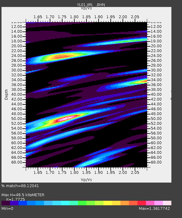
| Estimated Moho Depth: |
49.5 km |
| Estimated Crust Vp/Vs: |
1.77 |
| Assumed Crust Vp: |
6.236 km/s |
| Estimated Crust Vs: |
3.518 km/s |
| Estimated Crust Poisson's Ratio: |
0.27 |
|
| Radial Match: |
88.12041 % |
| Radial Bump: |
400 |
| Transverse Match: |
80.65807 % |
| Transverse Bump: |
400 |
| SOD ConfigId: |
16820 |
| Insert Time: |
2010-02-26 15:57:34.515 +0000 |
| GWidth: |
2.5 |
| Max Bumps: |
400 |
| Tol: |
0.001 |
|
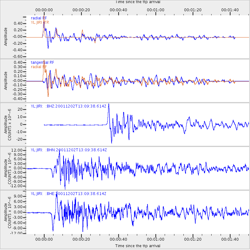
Signal To Noise
| Channel | StoN | STA | LTA |
| YL:JIRI: :BHN:20011202T13:09:38.614Z | 14.589144 | 1.5539774E-6 | 1.0651601E-7 |
| YL:JIRI: :BHE:20011202T13:09:38.614Z | 16.573195 | 2.5982336E-6 | 1.5677324E-7 |
| YL:JIRI: :BHZ:20011202T13:09:38.614Z | 119.50533 | 7.3745605E-6 | 6.1709045E-8 |
| Arrivals |
| Ps | 6.5 SECOND |
| PpPs | 21 SECOND |
| PsPs/PpSs | 27 SECOND |


