You are here: Home > Network List > XS99 - Montana BB Array Stations List
> Station N08 XS.N08 > Earthquake Result Viewer
N08 XS.N08 - Earthquake Result Viewer
| Earthquake location: |
Chile-Argentina Border Region |
| Earthquake latitude/longitude: |
-33.9/-70.1 |
| Earthquake time(UTC): |
2000/06/16 (168) 07:55:35 GMT |
| Earthquake Depth: |
120 km |
| Earthquake Magnitude: |
6.2 MB, 6.5 MW, 6.1 MD |
| Earthquake Catalog/Contributor: |
WHDF/NEIC |
|
| Network: |
XS Montana BB Array |
| Station: |
N08 XS.N08 |
| Lat/Lon: |
46.50 N/108.86 W |
| Elevation: |
1800 m |
|
| Distance: |
87.3 deg |
| Az: |
334.337 deg |
| Baz: |
148.562 deg |
| Ray Param: |
0.043159563 |
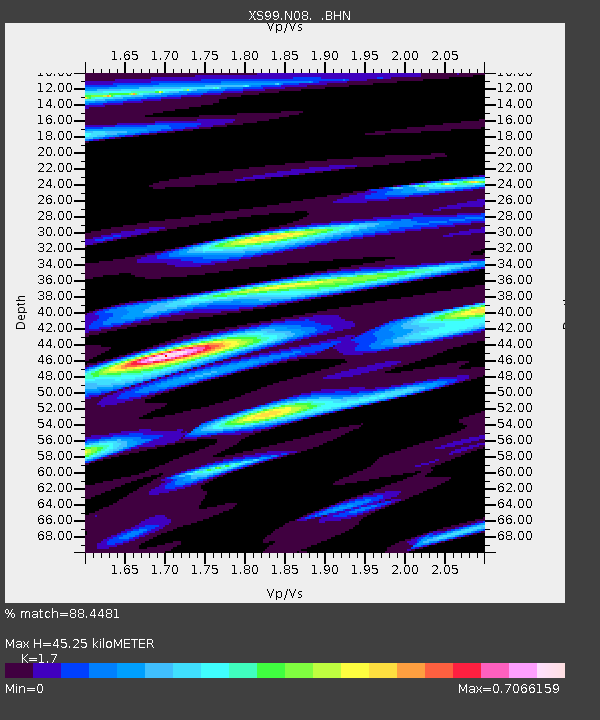
| Estimated Moho Depth: |
45.25 km |
| Estimated Crust Vp/Vs: |
1.70 |
| Assumed Crust Vp: |
6.518 km/s |
| Estimated Crust Vs: |
3.834 km/s |
| Estimated Crust Poisson's Ratio: |
0.24 |
|
| Radial Match: |
88.4481 % |
| Radial Bump: |
400 |
| Transverse Match: |
93.06302 % |
| Transverse Bump: |
400 |
| SOD ConfigId: |
20082 |
| Insert Time: |
2010-03-09 12:27:27.598 +0000 |
| GWidth: |
2.5 |
| Max Bumps: |
400 |
| Tol: |
0.001 |
|

Signal To Noise
| Channel | StoN | STA | LTA |
| XS:N08: :BHN:20000616T08:07:37.499009Z | 5.21655 | 6.765976E-7 | 1.2970213E-7 |
| XS:N08: :BHE:20000616T08:07:37.499009Z | 3.644221 | 1.0547895E-6 | 2.894417E-7 |
| XS:N08: :BHZ:20000616T08:07:37.499009Z | 26.759197 | 5.0158424E-6 | 1.8744367E-7 |
| Arrivals |
| Ps | 5.0 SECOND |
| PpPs | 18 SECOND |
| PsPs/PpSs | 23 SECOND |


