
Station XS N08 - XS.N08
Network: XS99 - Montana BB Array
Nearby stations (2 deg radius)

| Station | Name | (Lat, Lon) | Start / End | Elevation |
| N08 | XS.N08 | (46.50, -108.86) | 1999-08-21 / 2000-08-25 | 1800 m |
| Crust2 Type: | H6,early/mid Proter., U.S., 1.5 km seds. |
| Thickness Estimate: | 46 km |
| Thickness StdDev: | 1.9 km |
| Vp/Vs Estimate: | 1.78 |
| Vp/Vs StdDev: | 0.06 |
| Vs Estimate: | 3.657 km/s |
| Poisson's Ratio: | 0.27 |
| Peak Value: | 0.02 |
| Assumed Vp: | 6.518 km/s |
| Ps Weight: | 0.33333334 |
| PpPs Weight: | 0.33333334 |
| PsPs Weight: | 0.33333328 |
| Residual Complexity: | 0.572 |
| Nearby stations H: | +- |
| (2.0 deg) Vp/Vs: | +- |
4 with match > 90% ( 44.444443 %) and 9 with match > 80% ( 100.0 %) out of 9.
Download stack as xyz text file.
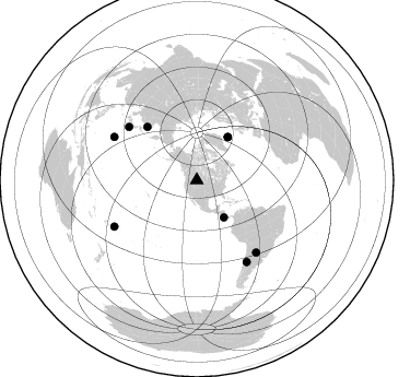
Azimuth Distribution of Events:
Prior Results for this Station
| Study | Thickness | Vp/Vs | Vp | Vs | Poissons Ratio | Extra |
| EARS | 46 km | 1.78 | 6.518 km/s | 3.657 km/s | 0.27 | |
| Crust2.0 | 52 km | 1.78 | 6.518 km/s | 3.665 km/s | 0.27 | H6,early/mid Proter., U.S., 1.5 km seds. |
| Global Maxima | 46 km | 1.78 | 6.518 km/s | 3.657 km/s | 0.27 | amp=0.02263412 |
| Local Maxima 1 | 42 km | 1.92 | 6.518 km/s | 3.386 km/s | 0.32 | amp=0.013693257 |
| Local Maxima 2 | 44 km | 1.75 | 6.518 km/s | 3.735 km/s | 0.26 | amp=0.008738009 |
| Local Maxima 3 | 58 km | 1.60 | 6.518 km/s | 4.074 km/s | 0.18 | amp=0.0071932115 |
| Local Maxima 4 | 48 km | 1.70 | 6.518 km/s | 3.846 km/s | 0.23 | amp=0.0059282277 |
| Predicted Arrivals for vertical incidence (zero ray parameter) | |
| Ps | 5.49 SECOND |
| PpPs | 19.53 SECOND |
| PsPs/PpSs | 25.02 SECOND |
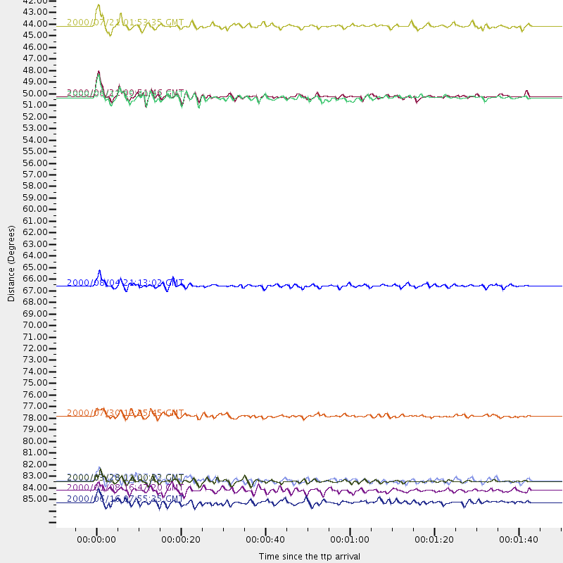
Events Processed for this Station
Download zip of receiver functions as SAC
Plot maxima for each earthquake.
Events Used in the Stack
(9 events)| Radial Match | Distance | Baz | FERegion | Time | Lat/Lon | Depth | Magnitude |
| 93.55729 | 85.3 deg | 297.574 deg | Volcano Islands, Japan Region | 2000/03/28 11:00:22 GMT | (22.3, 143.7) | 126 km | 6.8 MB, 7.6 MS, 7.6 MW, 7.6 MW |
| 92.291824 | 48.8 deg | 35.881 deg | Iceland | 2000/06/21 00:51:46 GMT | (64.0, -20.8) | 10 km | 6.1 MB, 6.6 MS, 6.5 MW, 6.4 MW |
| 91.88588 | 66.8 deg | 317.083 deg | Sakhalin, Russia | 2000/08/04 21:13:02 GMT | (48.8, 142.2) | 10 km | 6.3 MB, 7.1 MS, 6.8 MW, 6.7 MW |
| 91.155594 | 42.1 deg | 143.98 deg | Off Coast Of Costa Rica | 2000/07/21 01:53:35 GMT | (9.4, -85.3) | 33 km | 5.9 MB, 6.1 MS, 6.4 MW, 5.7 ML |
| 88.4481 | 87.3 deg | 148.562 deg | Chile-Argentina Border Region | 2000/06/16 07:55:35 GMT | (-33.9, -70.1) | 120 km | 6.2 MB, 6.5 MW, 6.1 MD |
| 85.85377 | 48.9 deg | 35.835 deg | Iceland | 2000/06/17 15:40:41 GMT | (64.0, -20.5) | 10 km | 5.7 MB, 6.6 MS, 6.8 MW, 6.5 MW |
| 85.50626 | 86.2 deg | 240.712 deg | Tonga Islands | 2000/01/08 16:47:20 GMT | (-16.9, -174.2) | 183 km | 6.5 MB, 6.6 MS, 7.2 MW, 7.0 ME |
| 83.517426 | 79.1 deg | 308.137 deg | Southeast Of Honshu, Japan | 2000/07/30 12:25:45 GMT | (33.9, 139.4) | 10 km | 6.0 MB, 6.5 MS, 6.5 MW, 6.5 MW |
| 81.65125 | 85.2 deg | 140.574 deg | Santiago Del Estero Prov., Arg. | 2000/04/23 09:27:23 GMT | (-28.3, -63.0) | 608 km | 6.6 MB, 7.0 MW, 7.0 MW |
Losers
(0 events)| Radial Match | Distance | Baz | FERegion | Time | Lat/Lon | Depth | Magnitude | Reason |
