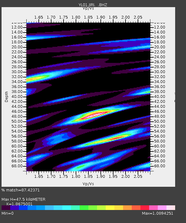
JIRI YL.JIRI - Earthquake Result Viewer

Earthquake location: South Of Australia
Earthquake latitude/longitude: -51.1/139.3
Earthquake time(UTC): 2002/04/08 (098) 03:48:55 GMT
Earthquake Depth: 10 km
Earthquake Magnitude: 5.6 MB, 6.1 MS, 6.2 MW, 6.2 MW
Earthquake Catalog/Contributor: WHDF/NEIC
Network: YL Himalayan Nepal Tibet Experiment
Station: JIRI YL.JIRI
Lat/Lon: 27.63 N/86.23 E
Elevation: 1866 m
Distance: 91.2 deg
Az: 314.84 deg
Baz: 149.717 deg
Ray Param: 0.041617278
Estimated Moho Depth: 47.5 km
Estimated Crust Vp/Vs: 1.87
Assumed Crust Vp: 6.236 km/s
Estimated Crust Vs: 3.339 km/s
Estimated Crust Poisson's Ratio: 0.30
Radial Match: 87.42371 %
Radial Bump: 400
Transverse Match: 78.74793 %
Transverse Bump: 400
SOD ConfigId: 16820
Insert Time: 2010-02-26 15:57:38.639 +0000
GWidth: 2.5
Max Bumps: 400
Tol: 0.001

Signal To Noise

ChannelStoNSTALTA
YL:JIRI: :BHZ:20020408T04:01:28.932017Z1.01556675.051499E-84.974069E-8
YL:JIRI: :BHN:20020408T04:01:28.932017Z0.67895654.5324256E-86.675576E-8
YL:JIRI: :BHE:20020408T04:01:28.932017Z0.815730045.3789904E-86.594082E-8
Arrivals
Ps6.7 SECOND
PpPs21 SECOND
PsPs/PpSs28 SECOND