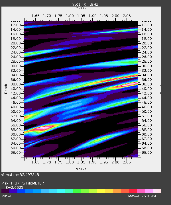
JIRI YL.JIRI - Earthquake Result Viewer
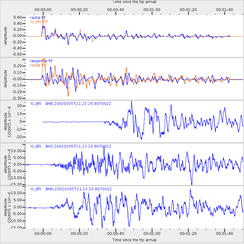
Earthquake location: Mindanao, Philippines
Earthquake latitude/longitude: 6.0/124.2
Earthquake time(UTC): 2002/03/05 (064) 21:16:09 GMT
Earthquake Depth: 31 km
Earthquake Magnitude: 6.3 MB, 7.2 MS, 7.5 MW, 7.2 MW
Earthquake Catalog/Contributor: WHDF/NEIC
Network: YL Himalayan Nepal Tibet Experiment
Station: JIRI YL.JIRI
Lat/Lon: 27.63 N/86.23 E
Elevation: 1866 m
Distance: 42.0 deg
Az: 305.229 deg
Baz: 113.698 deg
Ray Param: 0.07338073
Estimated Moho Depth: 37.75 km
Estimated Crust Vp/Vs: 2.06
Assumed Crust Vp: 6.236 km/s
Estimated Crust Vs: 3.023 km/s
Estimated Crust Poisson's Ratio: 0.35
Radial Match: 83.497345 %
Radial Bump: 400
Transverse Match: 81.481705 %
Transverse Bump: 400
SOD ConfigId: 16820
Insert Time: 2010-02-26 15:57:44.889 +0000
GWidth: 2.5
Max Bumps: 400
Tol: 0.001

Signal To Noise

ChannelStoNSTALTA
YL:JIRI: :BHZ:20020305T21:23:26.807002Z2.4521281.7684204E-77.2117786E-8
YL:JIRI: :BHN:20020305T21:23:26.807002Z2.72354562.2769474E-78.360232E-8
YL:JIRI: :BHE:20020305T21:23:26.807002Z3.38572813.3384813E-79.860453E-8
Arrivals
Ps6.8 SECOND
PpPs18 SECOND
PsPs/PpSs24 SECOND