You are here: Home > Network List > XS99 - Montana BB Array Stations List
> Station S05 XS.S05 > Earthquake Result Viewer
S05 XS.S05 - Earthquake Result Viewer
| Earthquake location: |
Bonin Islands, Japan Region |
| Earthquake latitude/longitude: |
28.9/139.6 |
| Earthquake time(UTC): |
2000/08/06 (219) 07:27:12 GMT |
| Earthquake Depth: |
395 km |
| Earthquake Magnitude: |
6.3 MB, 7.3 MW, 7.3 MW |
| Earthquake Catalog/Contributor: |
WHDF/NEIC |
|
| Network: |
XS Montana BB Array |
| Station: |
S05 XS.S05 |
| Lat/Lon: |
45.41 N/108.94 W |
| Elevation: |
1800 m |
|
| Distance: |
83.4 deg |
| Az: |
41.274 deg |
| Baz: |
304.762 deg |
| Ray Param: |
0.04512862 |
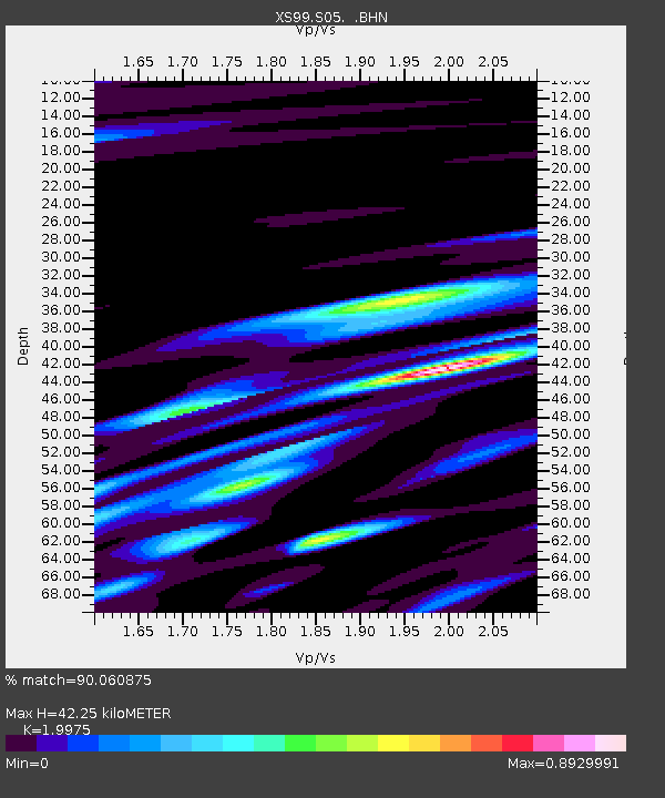
| Estimated Moho Depth: |
42.25 km |
| Estimated Crust Vp/Vs: |
2.00 |
| Assumed Crust Vp: |
6.242 km/s |
| Estimated Crust Vs: |
3.125 km/s |
| Estimated Crust Poisson's Ratio: |
0.33 |
|
| Radial Match: |
90.060875 % |
| Radial Bump: |
366 |
| Transverse Match: |
76.98719 % |
| Transverse Bump: |
400 |
| SOD ConfigId: |
20082 |
| Insert Time: |
2010-03-09 12:30:54.146 +0000 |
| GWidth: |
2.5 |
| Max Bumps: |
400 |
| Tol: |
0.001 |
|

Signal To Noise
| Channel | StoN | STA | LTA |
| XS:S05: :BHN:20000806T07:38:26.100012Z | 2.5887055 | 7.5146994E-7 | 2.9028791E-7 |
| XS:S05: :BHE:20000806T07:38:26.100012Z | 2.7749467 | 1.0180042E-6 | 3.6685543E-7 |
| XS:S05: :BHZ:20000806T07:38:26.100012Z | 9.893775 | 2.989185E-6 | 3.0212786E-7 |
| Arrivals |
| Ps | 6.9 SECOND |
| PpPs | 20 SECOND |
| PsPs/PpSs | 27 SECOND |


