
Station XS S05 - XS.S05
Network: XS99 - Montana BB Array
Nearby stations (2 deg radius)
| Station | Name | (Lat, Lon) | Start / End | Elevation |
| S05 | XS.S05 | (45.41, -108.94) | 1999-08-21 / 2000-08-25 | 1800 m |
| Crust2 Type: | PD,orogen/50km, Tibet, 2 km seds. |
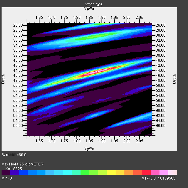
| Thickness Estimate: | 44 km |
| Thickness StdDev: | 8.6 km |
| Vp/Vs Estimate: | 1.88 |
| Vp/Vs StdDev: | 0.09 |
| Vs Estimate: | 3.316 km/s |
| Poisson's Ratio: | 0.30 |
| Peak Value: | 0.01 |
| Assumed Vp: | 6.242 km/s |
| Ps Weight: | 0.33333334 |
| PpPs Weight: | 0.33333334 |
| PsPs Weight: | 0.33333328 |
| Residual Complexity: | 0.747 |
| Nearby stations H: | +- |
| (2.0 deg) Vp/Vs: | +- |
5 with match > 90% ( 41.666668 %) and 12 with match > 80% ( 100.0 %) out of 12.
Download stack as xyz text file.
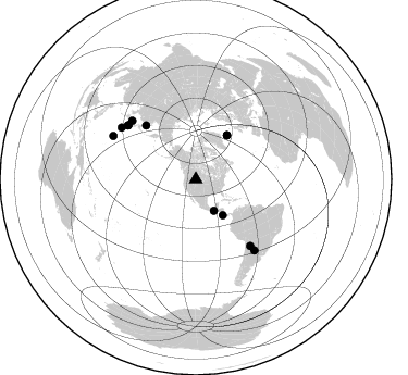
Azimuth Distribution of Events:
Prior Results for this Station
| Study | Thickness | Vp/Vs | Vp | Vs | Poissons Ratio | Extra |
| EARS | 44 km | 1.88 | 6.242 km/s | 3.316 km/s | 0.30 | |
| Crust2.0 | 50 km | 1.76 | 6.242 km/s | 3.546 km/s | 0.26 | PD,orogen/50km, Tibet, 2 km seds. |
| Global Maxima | 44 km | 1.88 | 6.242 km/s | 3.316 km/s | 0.30 | amp=0.0110129565 |
| Local Maxima 1 | 25 km | 1.91 | 6.242 km/s | 3.26 km/s | 0.31 | amp=0.006243245 |
| Local Maxima 2 | 30 km | 1.88 | 6.242 km/s | 3.325 km/s | 0.30 | amp=0.0057351505 |
| Local Maxima 3 | 49 km | 1.71 | 6.242 km/s | 3.661 km/s | 0.24 | amp=0.0057073273 |
| Local Maxima 4 | 42 km | 1.97 | 6.242 km/s | 3.173 km/s | 0.33 | amp=0.004212196 |
| Predicted Arrivals for vertical incidence (zero ray parameter) | |
| Ps | 6.26 SECOND |
| PpPs | 20.43 SECOND |
| PsPs/PpSs | 26.69 SECOND |
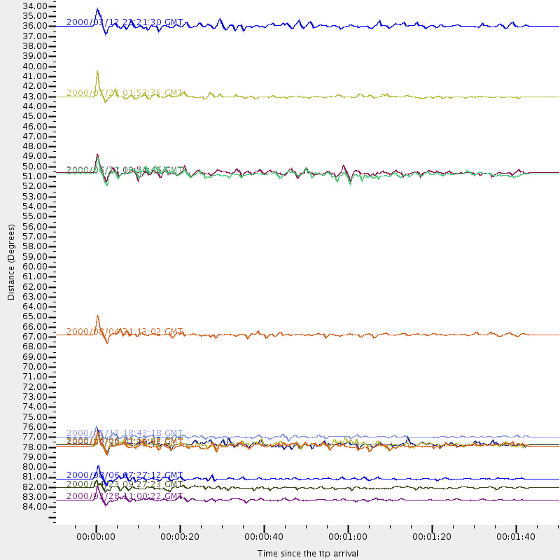
Events Processed for this Station
Download zip of receiver functions as SAC
Plot maxima for each earthquake.
Events Used in the Stack
(12 events)| Radial Match | Distance | Baz | FERegion | Time | Lat/Lon | Depth | Magnitude |
| 96.44709 | 78.8 deg | 140.807 deg | Jujuy Province, Argentina | 2000/05/12 18:43:18 GMT | (-23.5, -66.5) | 225 km | 6.2 MB, 7.2 MW, 7.1 MW |
| 96.43555 | 85.8 deg | 297.594 deg | Volcano Islands, Japan Region | 2000/03/28 11:00:22 GMT | (22.3, 143.7) | 126 km | 6.8 MB, 7.6 MS, 7.6 MW, 7.6 MW |
| 95.295456 | 67.5 deg | 317.354 deg | Sakhalin, Russia | 2000/08/04 21:13:02 GMT | (48.8, 142.2) | 10 km | 6.3 MB, 7.1 MS, 6.8 MW, 6.7 MW |
| 94.5688 | 41.2 deg | 143.148 deg | Off Coast Of Costa Rica | 2000/07/21 01:53:35 GMT | (9.4, -85.3) | 33 km | 5.9 MB, 6.1 MS, 6.4 MW, 5.7 ML |
| 90.060875 | 83.4 deg | 304.762 deg | Bonin Islands, Japan Region | 2000/08/06 07:27:12 GMT | (28.9, 139.6) | 395 km | 6.3 MB, 7.3 MW, 7.3 MW |
| 89.217545 | 84.4 deg | 140.451 deg | Santiago Del Estero Prov., Arg. | 2000/04/23 09:27:23 GMT | (-28.3, -63.0) | 608 km | 6.6 MB, 7.0 MW, 7.0 MW |
| 88.56487 | 79.8 deg | 308.246 deg | Southeast Of Honshu, Japan | 2000/07/30 12:25:45 GMT | (33.9, 139.4) | 10 km | 6.0 MB, 6.5 MS, 6.5 MW, 6.5 MW |
| 88.52388 | 49.7 deg | 35.318 deg | Iceland | 2000/06/21 00:51:46 GMT | (64.0, -20.8) | 10 km | 6.1 MB, 6.6 MS, 6.5 MW, 6.4 MW |
| 84.56478 | 49.8 deg | 35.274 deg | Iceland | 2000/06/17 15:40:41 GMT | (64.0, -20.5) | 10 km | 5.7 MB, 6.6 MS, 6.8 MW, 6.5 MW |
| 83.96754 | 79.7 deg | 312.645 deg | Sea Of Japan | 2000/06/06 21:16:42 GMT | (36.8, 135.5) | 10 km | 5.7 MB, 5.3 MS, 5.9 MW, 5.8 MW |
| 83.71594 | 33.4 deg | 150.084 deg | Near Coast Of Chiapas, Mexico | 2000/03/12 22:21:30 GMT | (15.0, -92.4) | 62 km | 5.5 MB, 5.8 MS, 6.3 MW, 5.4 MD |
| 80.079315 | 79.7 deg | 308.616 deg | Near S. Coast Of Honshu, Japan | 2000/07/01 07:01:55 GMT | (34.2, 139.1) | 10 km | 6.0 MB, 6.1 MS, 6.2 MW, 6.2 MW |
Losers
(0 events)| Radial Match | Distance | Baz | FERegion | Time | Lat/Lon | Depth | Magnitude | Reason |
