You are here: Home > Network List > XS99 - Montana BB Array Stations List
> Station S05 XS.S05 > Earthquake Result Viewer
S05 XS.S05 - Earthquake Result Viewer
| Earthquake location: |
Sea Of Japan |
| Earthquake latitude/longitude: |
36.8/135.5 |
| Earthquake time(UTC): |
2000/06/06 (158) 21:16:42 GMT |
| Earthquake Depth: |
10 km |
| Earthquake Magnitude: |
5.7 MB, 5.3 MS, 5.9 MW, 5.8 MW |
| Earthquake Catalog/Contributor: |
WHDF/NEIC |
|
| Network: |
XS Montana BB Array |
| Station: |
S05 XS.S05 |
| Lat/Lon: |
45.41 N/108.94 W |
| Elevation: |
1800 m |
|
| Distance: |
79.7 deg |
| Az: |
40.22 deg |
| Baz: |
312.645 deg |
| Ray Param: |
0.04880934 |
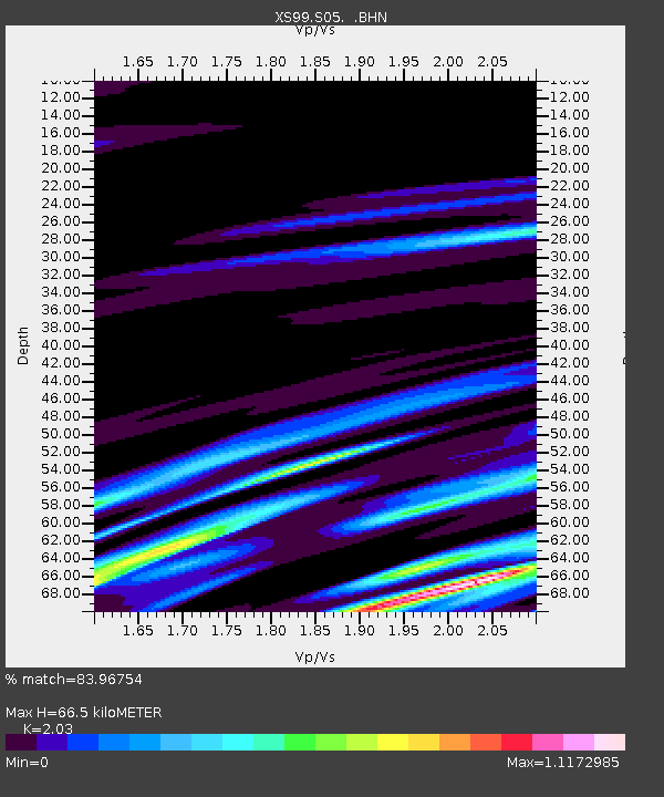
| Estimated Moho Depth: |
66.5 km |
| Estimated Crust Vp/Vs: |
2.03 |
| Assumed Crust Vp: |
6.242 km/s |
| Estimated Crust Vs: |
3.075 km/s |
| Estimated Crust Poisson's Ratio: |
0.34 |
|
| Radial Match: |
83.96754 % |
| Radial Bump: |
400 |
| Transverse Match: |
57.46153 % |
| Transverse Bump: |
400 |
| SOD ConfigId: |
20082 |
| Insert Time: |
2010-03-09 12:31:02.667 +0000 |
| GWidth: |
2.5 |
| Max Bumps: |
400 |
| Tol: |
0.001 |
|

Signal To Noise
| Channel | StoN | STA | LTA |
| XS:S05: :BHN:20000606T21:28:18.574011Z | 1.9247535 | 6.548895E-7 | 3.402459E-7 |
| XS:S05: :BHE:20000606T21:28:18.574011Z | 0.91844934 | 4.3006781E-7 | 4.6825426E-7 |
| XS:S05: :BHZ:20000606T21:28:18.574011Z | 5.1232166 | 1.1285306E-6 | 2.2027774E-7 |
| Arrivals |
| Ps | 11 SECOND |
| PpPs | 32 SECOND |
| PsPs/PpSs | 43 SECOND |


