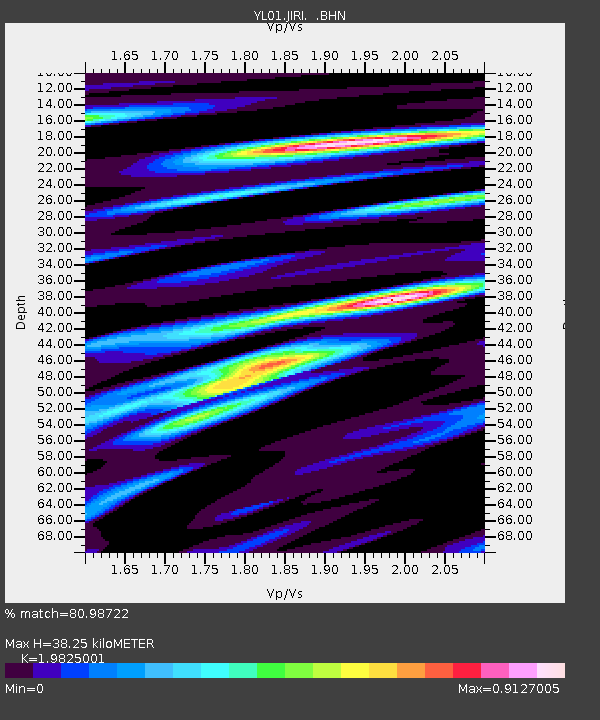
JIRI YL.JIRI - Earthquake Result Viewer
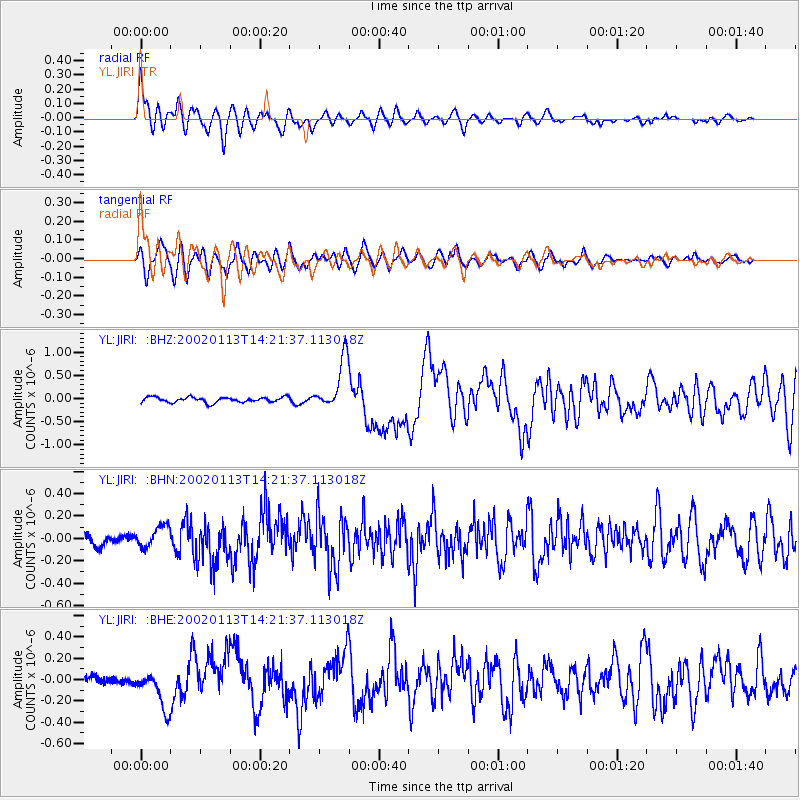
Earthquake location: New Britain Region, P.N.G.
Earthquake latitude/longitude: -5.7/151.1
Earthquake time(UTC): 2002/01/13 (013) 14:10:56 GMT
Earthquake Depth: 44 km
Earthquake Magnitude: 5.9 MB, 6.4 MS, 6.3 MW, 6.3 MW
Earthquake Catalog/Contributor: WHDF/NEIC
Network: YL Himalayan Nepal Tibet Experiment
Station: JIRI YL.JIRI
Lat/Lon: 27.63 N/86.23 E
Elevation: 1866 m
Distance: 70.7 deg
Az: 301.704 deg
Baz: 107.381 deg
Ray Param: 0.054716736
Estimated Moho Depth: 38.25 km
Estimated Crust Vp/Vs: 1.98
Assumed Crust Vp: 6.236 km/s
Estimated Crust Vs: 3.145 km/s
Estimated Crust Poisson's Ratio: 0.33
Radial Match: 80.98722 %
Radial Bump: 400
Transverse Match: 71.07102 %
Transverse Bump: 400
SOD ConfigId: 16820
Insert Time: 2010-02-26 15:57:51.709 +0000
GWidth: 2.5
Max Bumps: 400
Tol: 0.001

Signal To Noise

ChannelStoNSTALTA
YL:JIRI: :BHN:20020113T14:21:37.113018Z1.57201569.5720274E-86.089015E-8
YL:JIRI: :BHE:20020113T14:21:37.113018Z4.5350491.7803006E-73.9256477E-8
YL:JIRI: :BHZ:20020113T14:21:37.113018Z9.7887515.4704867E-75.5885447E-8
Arrivals
Ps6.2 SECOND
PpPs18 SECOND
PsPs/PpSs24 SECOND