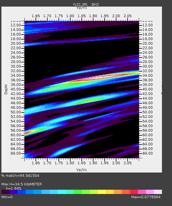
JIRI YL.JIRI - Earthquake Result Viewer
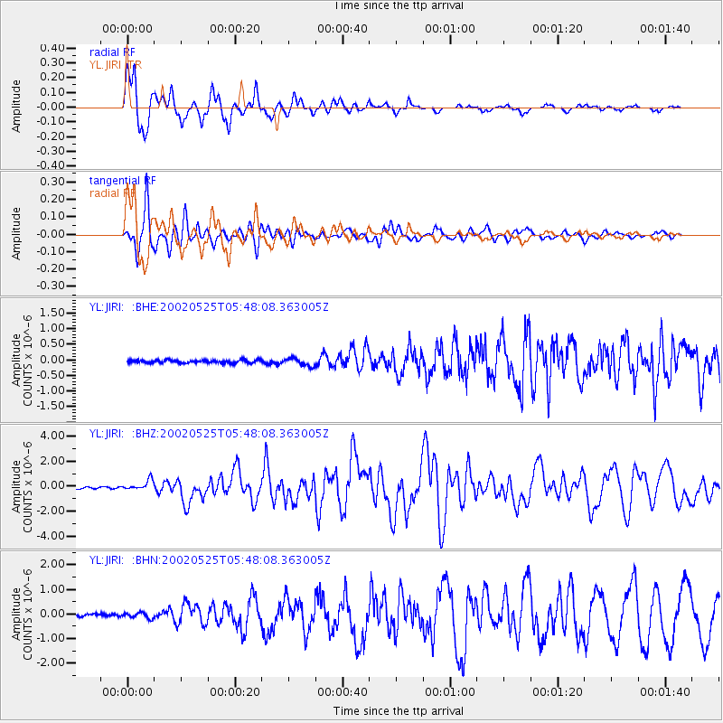
Earthquake location: South Of Alaska
Earthquake latitude/longitude: 53.8/-161.1
Earthquake time(UTC): 2002/05/25 (145) 05:36:31 GMT
Earthquake Depth: 33 km
Earthquake Magnitude: 5.5 MB, 6.1 MS, 6.5 MW, 6.4 MW
Earthquake Catalog/Contributor: WHDF/NEIC
Network: YL Himalayan Nepal Tibet Experiment
Station: JIRI YL.JIRI
Lat/Lon: 27.63 N/86.23 E
Elevation: 1866 m
Distance: 80.3 deg
Az: 303.831 deg
Baz: 33.725 deg
Ray Param: 0.04834173
Estimated Moho Depth: 34.5 km
Estimated Crust Vp/Vs: 1.95
Assumed Crust Vp: 6.236 km/s
Estimated Crust Vs: 3.206 km/s
Estimated Crust Poisson's Ratio: 0.32
Radial Match: 94.561554 %
Radial Bump: 400
Transverse Match: 90.13556 %
Transverse Bump: 400
SOD ConfigId: 16844
Insert Time: 2010-02-26 15:57:58.285 +0000
GWidth: 2.5
Max Bumps: 400
Tol: 0.001

Signal To Noise

ChannelStoNSTALTA
YL:JIRI: :BHZ:20020525T05:48:08.363005Z4.42929554.0574284E-79.160437E-8
YL:JIRI: :BHN:20020525T05:48:08.363005Z1.27807711.13992904E-78.919095E-8
YL:JIRI: :BHE:20020525T05:48:08.363005Z2.54654881.2370906E-74.8579103E-8
Arrivals
Ps5.4 SECOND
PpPs16 SECOND
PsPs/PpSs21 SECOND