JIRI YL.JIRI - Earthquake Result Viewer
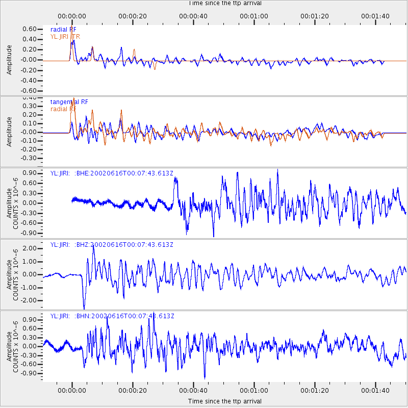
Earthquake location: Minahassa Peninsula, Sulawesi
Earthquake latitude/longitude: 0.5/119.9
Earthquake time(UTC): 2002/06/16 (167) 00:00:25 GMT
Earthquake Depth: 35 km
Earthquake Magnitude: 5.7 MB, 5.5 MS, 5.9 MW, 5.8 MW
Earthquake Catalog/Contributor: WHDF/NEIC
Network: YL Himalayan Nepal Tibet Experiment
Station: JIRI YL.JIRI
Lat/Lon: 27.63 N/86.23 E
Elevation: 1866 m
Distance: 42.1 deg
Az: 312.771 deg
Baz: 124.171 deg
Ray Param: 0.07331835
Estimated Moho Depth: 37.25 km
Estimated Crust Vp/Vs: 1.88
Assumed Crust Vp: 6.236 km/s
Estimated Crust Vs: 3.308 km/s
Estimated Crust Poisson's Ratio: 0.30
Radial Match: 80.422 %
Radial Bump: 400
Transverse Match: 66.32463 %
Transverse Bump: 400
SOD ConfigId: 16844
Insert Time: 2010-02-26 15:58:02.708 +0000
GWidth: 2.5
Max Bumps: 400
Tol: 0.001

Signal To Noise

ChannelStoNSTALTA
YL:JIRI: :BHZ:20020616T00:07:43.613Z9.25369558.9008586E-79.618707E-8
YL:JIRI: :BHN:20020616T00:07:43.613Z1.77835792.2890528E-71.2871722E-7
YL:JIRI: :BHE:20020616T00:07:43.613Z4.44855073.2337434E-77.269206E-8
Arrivals
Ps5.6 SECOND
PpPs16 SECOND
PsPs/PpSs22 SECOND