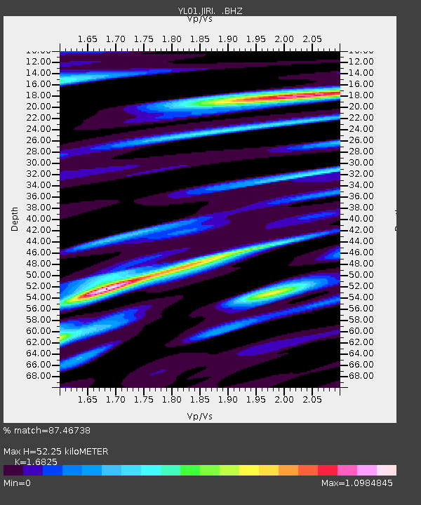
JIRI YL.JIRI - Earthquake Result Viewer

Earthquake location: Santa Cruz Islands
Earthquake latitude/longitude: -12.6/166.4
Earthquake time(UTC): 2002/06/17 (168) 21:26:22 GMT
Earthquake Depth: 33 km
Earthquake Magnitude: 6.0 MB, 6.7 MS, 6.7 MW, 6.6 MW
Earthquake Catalog/Contributor: WHDF/NEIC
Network: YL Himalayan Nepal Tibet Experiment
Station: JIRI YL.JIRI
Lat/Lon: 27.63 N/86.23 E
Elevation: 1866 m
Distance: 87.2 deg
Az: 298.938 deg
Baz: 105.636 deg
Ray Param: 0.043424144
Estimated Moho Depth: 52.25 km
Estimated Crust Vp/Vs: 1.68
Assumed Crust Vp: 6.236 km/s
Estimated Crust Vs: 3.706 km/s
Estimated Crust Poisson's Ratio: 0.23
Radial Match: 87.46738 %
Radial Bump: 400
Transverse Match: 81.9271 %
Transverse Bump: 400
SOD ConfigId: 16844
Insert Time: 2010-02-26 15:58:08.082 +0000
GWidth: 2.5
Max Bumps: 400
Tol: 0.001

Signal To Noise

ChannelStoNSTALTA
YL:JIRI: :BHZ:20020617T21:38:34.763018Z6.45300256.574515E-71.01883046E-7
YL:JIRI: :BHN:20020617T21:38:34.763018Z0.53754063.9851642E-87.4136985E-8
YL:JIRI: :BHE:20020617T21:38:34.763018Z1.67799939.6688815E-85.7621488E-8
Arrivals
Ps5.8 SECOND
PpPs22 SECOND
PsPs/PpSs28 SECOND