You are here: Home > Network List > XS99 - Montana BB Array Stations List
> Station S15 XS.S15 > Earthquake Result Viewer
S15 XS.S15 - Earthquake Result Viewer
| Earthquake location: |
Sea Of Japan |
| Earthquake latitude/longitude: |
36.8/135.5 |
| Earthquake time(UTC): |
2000/06/06 (158) 21:16:42 GMT |
| Earthquake Depth: |
10 km |
| Earthquake Magnitude: |
5.7 MB, 5.3 MS, 5.9 MW, 5.8 MW |
| Earthquake Catalog/Contributor: |
WHDF/NEIC |
|
| Network: |
XS Montana BB Array |
| Station: |
S15 XS.S15 |
| Lat/Lon: |
45.83 N/108.82 W |
| Elevation: |
1800 m |
|
| Distance: |
79.4 deg |
| Az: |
39.853 deg |
| Baz: |
312.666 deg |
| Ray Param: |
0.048958026 |
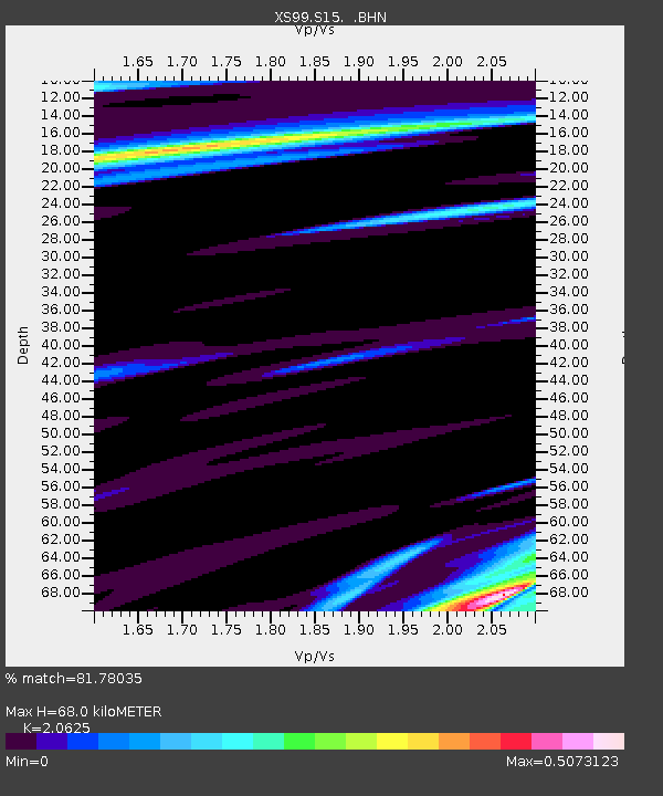
| Estimated Moho Depth: |
68.0 km |
| Estimated Crust Vp/Vs: |
2.06 |
| Assumed Crust Vp: |
6.242 km/s |
| Estimated Crust Vs: |
3.026 km/s |
| Estimated Crust Poisson's Ratio: |
0.35 |
|
| Radial Match: |
81.78035 % |
| Radial Bump: |
400 |
| Transverse Match: |
81.79864 % |
| Transverse Bump: |
400 |
| SOD ConfigId: |
20082 |
| Insert Time: |
2010-03-09 12:34:17.335 +0000 |
| GWidth: |
2.5 |
| Max Bumps: |
400 |
| Tol: |
0.001 |
|

Signal To Noise
| Channel | StoN | STA | LTA |
| XS:S15: :BHN:20000606T21:28:17.400Z | 1.1840605 | 3.09503E-7 | 2.6139122E-7 |
| XS:S15: :BHE:20000606T21:28:17.400Z | 1.8083014 | 4.2439805E-7 | 2.346943E-7 |
| XS:S15: :BHZ:20000606T21:28:17.400Z | 8.641811 | 1.6438757E-6 | 1.902235E-7 |
| Arrivals |
| Ps | 12 SECOND |
| PpPs | 33 SECOND |
| PsPs/PpSs | 44 SECOND |


