
Station XS S15 - XS.S15
Network: XS99 - Montana BB Array
Nearby stations (2 deg radius)
| Station | Name | (Lat, Lon) | Start / End | Elevation |
| S15 | XS.S15 | (45.83, -108.82) | 1999-08-21 / 2000-08-25 | 1800 m |
| Crust2 Type: | PD,orogen/50km, Tibet, 2 km seds. |
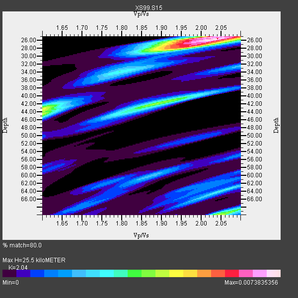
| Thickness Estimate: | 26 km |
| Thickness StdDev: | 15 km |
| Vp/Vs Estimate: | 2.04 |
| Vp/Vs StdDev: | 0.07 |
| Vs Estimate: | 3.06 km/s |
| Poisson's Ratio: | 0.34 |
| Peak Value: | 0.01 |
| Assumed Vp: | 6.242 km/s |
| Ps Weight: | 0.33333334 |
| PpPs Weight: | 0.33333334 |
| PsPs Weight: | 0.33333328 |
| Residual Complexity: | 0.654 |
| Nearby stations H: | +- |
| (2.0 deg) Vp/Vs: | +- |
5 with match > 90% ( 33.333332 %) and 15 with match > 80% ( 100.0 %) out of 15.
Download stack as xyz text file.
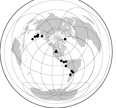
Azimuth Distribution of Events:
Prior Results for this Station
| Study | Thickness | Vp/Vs | Vp | Vs | Poissons Ratio | Extra |
| EARS | 26 km | 2.04 | 6.242 km/s | 3.06 km/s | 0.34 | |
| Crust2.0 | 50 km | 1.76 | 6.242 km/s | 3.546 km/s | 0.26 | PD,orogen/50km, Tibet, 2 km seds. |
| Global Maxima | 26 km | 2.04 | 6.242 km/s | 3.06 km/s | 0.34 | amp=0.0073835356 |
| Local Maxima 1 | 42 km | 1.88 | 6.242 km/s | 3.32 km/s | 0.30 | amp=0.004075683 |
| Local Maxima 2 | 28 km | 1.96 | 6.242 km/s | 3.181 km/s | 0.32 | amp=0.0039570583 |
| Local Maxima 3 | 70 km | 2.04 | 6.242 km/s | 3.056 km/s | 0.34 | amp=0.003906253 |
| Local Maxima 4 | 64 km | 2.05 | 6.242 km/s | 3.041 km/s | 0.34 | amp=0.0030753396 |
| Predicted Arrivals for vertical incidence (zero ray parameter) | |
| Ps | 4.25 SECOND |
| PpPs | 12.42 SECOND |
| PsPs/PpSs | 16.67 SECOND |
Events Processed for this Station
Download zip of receiver functions as SAC
Plot maxima for each earthquake.
Events Used in the Stack
(15 events)| Radial Match | Distance | Baz | FERegion | Time | Lat/Lon | Depth | Magnitude |
| 96.30369 | 85.6 deg | 297.651 deg | Volcano Islands, Japan Region | 2000/03/28 11:00:22 GMT | (22.3, 143.7) | 126 km | 6.8 MB, 7.6 MS, 7.6 MW, 7.6 MW |
| 96.18582 | 67.3 deg | 317.298 deg | Sakhalin, Russia | 2000/08/04 21:13:02 GMT | (48.8, 142.2) | 10 km | 6.3 MB, 7.1 MS, 6.8 MW, 6.7 MW |
| 93.89656 | 79.0 deg | 140.958 deg | Jujuy Province, Argentina | 2000/05/12 18:43:18 GMT | (-23.5, -66.5) | 225 km | 6.2 MB, 7.2 MW, 7.1 MW |
| 91.55566 | 86.7 deg | 148.576 deg | Chile-Argentina Border Region | 2000/06/16 07:55:35 GMT | (-33.9, -70.1) | 120 km | 6.2 MB, 6.5 MW, 6.1 MD |
| 90.93594 | 41.5 deg | 143.593 deg | Off Coast Of Costa Rica | 2000/07/21 01:53:35 GMT | (9.4, -85.3) | 33 km | 5.9 MB, 6.1 MS, 6.4 MW, 5.7 ML |
| 89.55728 | 83.3 deg | 304.804 deg | Bonin Islands, Japan Region | 2000/08/06 07:27:12 GMT | (28.9, 139.6) | 395 km | 6.3 MB, 7.3 MW, 7.3 MW |
| 86.87267 | 49.4 deg | 35.505 deg | Iceland | 2000/06/17 15:40:41 GMT | (64.0, -20.5) | 10 km | 5.7 MB, 6.6 MS, 6.8 MW, 6.5 MW |
| 86.7228 | 84.7 deg | 140.569 deg | Santiago Del Estero Prov., Arg. | 2000/04/23 09:27:23 GMT | (-28.3, -63.0) | 608 km | 6.6 MB, 7.0 MW, 7.0 MW |
| 86.55602 | 33.7 deg | 150.591 deg | Near Coast Of Chiapas, Mexico | 2000/03/12 22:21:30 GMT | (15.0, -92.4) | 62 km | 5.5 MB, 5.8 MS, 6.3 MW, 5.4 MD |
| 85.32463 | 44.6 deg | 134.883 deg | Panama | 2000/02/26 18:24:39 GMT | (9.4, -78.5) | 65 km | 5.8 MB, 5.4 MS, 6.2 MW, 6.1 MW |
| 84.00592 | 76.8 deg | 309.036 deg | Near East Coast Of Honshu, Japan | 2000/07/20 18:39:18 GMT | (36.5, 141.0) | 47 km | 6.1 MB, 5.4 MS, 6.1 ME, 6.0 MW |
| 82.56488 | 49.3 deg | 35.55 deg | Iceland | 2000/06/21 00:51:46 GMT | (64.0, -20.8) | 10 km | 6.1 MB, 6.6 MS, 6.5 MW, 6.4 MW |
| 82.32388 | 55.5 deg | 145.725 deg | Near Coast Of Northern Peru | 2000/05/22 13:15:08 GMT | (-4.1, -81.1) | 33 km | 5.3 MB, 5.4 MS, 5.8 MW, 5.8 MW |
| 81.78035 | 79.4 deg | 312.666 deg | Sea Of Japan | 2000/06/06 21:16:42 GMT | (36.8, 135.5) | 10 km | 5.7 MB, 5.3 MS, 5.9 MW, 5.8 MW |
| 81.28331 | 79.6 deg | 308.264 deg | Southeast Of Honshu, Japan | 2000/07/30 12:25:45 GMT | (33.9, 139.4) | 10 km | 6.0 MB, 6.5 MS, 6.5 MW, 6.5 MW |
Losers
(0 events)| Radial Match | Distance | Baz | FERegion | Time | Lat/Lon | Depth | Magnitude | Reason |
