You are here: Home > Network List > XS99 - Montana BB Array Stations List
> Station S15 XS.S15 > Earthquake Result Viewer
S15 XS.S15 - Earthquake Result Viewer
| Earthquake location: |
Jujuy Province, Argentina |
| Earthquake latitude/longitude: |
-23.5/-66.5 |
| Earthquake time(UTC): |
2000/05/12 (133) 18:43:18 GMT |
| Earthquake Depth: |
225 km |
| Earthquake Magnitude: |
6.2 MB, 7.2 MW, 7.1 MW |
| Earthquake Catalog/Contributor: |
WHDF/NEIC |
|
| Network: |
XS Montana BB Array |
| Station: |
S15 XS.S15 |
| Lat/Lon: |
45.83 N/108.82 W |
| Elevation: |
1800 m |
|
| Distance: |
79.0 deg |
| Az: |
331.319 deg |
| Baz: |
140.958 deg |
| Ray Param: |
0.04865589 |
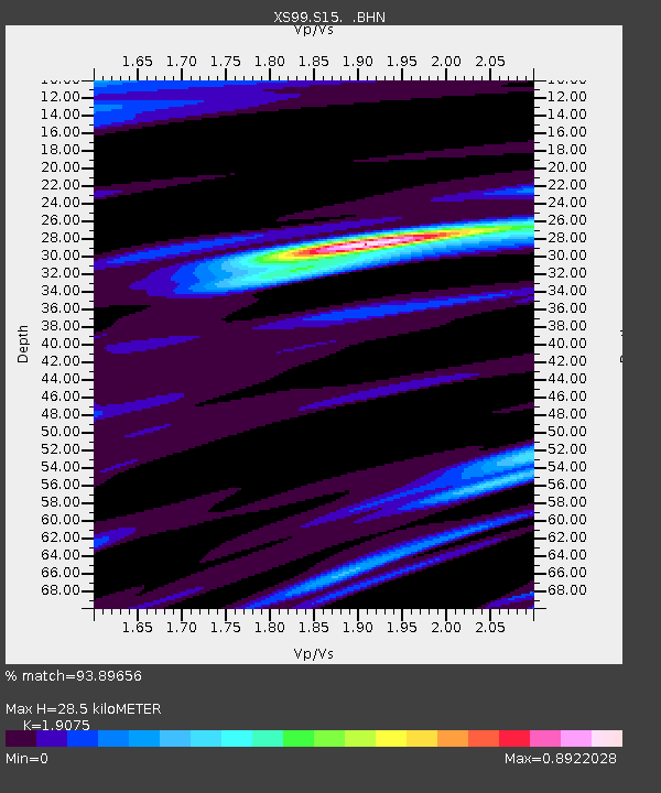
| Estimated Moho Depth: |
28.5 km |
| Estimated Crust Vp/Vs: |
1.91 |
| Assumed Crust Vp: |
6.242 km/s |
| Estimated Crust Vs: |
3.272 km/s |
| Estimated Crust Poisson's Ratio: |
0.31 |
|
| Radial Match: |
93.89656 % |
| Radial Bump: |
400 |
| Transverse Match: |
85.02176 % |
| Transverse Bump: |
400 |
| SOD ConfigId: |
20082 |
| Insert Time: |
2010-03-09 12:34:18.769 +0000 |
| GWidth: |
2.5 |
| Max Bumps: |
400 |
| Tol: |
0.001 |
|

Signal To Noise
| Channel | StoN | STA | LTA |
| XS:S15: :BHN:20000512T18:54:26.025029Z | 2.1939416 | 7.3861383E-7 | 3.3666066E-7 |
| XS:S15: :BHE:20000512T18:54:26.025029Z | 1.1552151 | 5.199379E-7 | 4.5007886E-7 |
| XS:S15: :BHZ:20000512T18:54:26.025029Z | 14.25752 | 3.5937612E-6 | 2.5206074E-7 |
| Arrivals |
| Ps | 4.2 SECOND |
| PpPs | 13 SECOND |
| PsPs/PpSs | 17 SECOND |


