You are here: Home > Network List > XS99 - Montana BB Array Stations List
> Station S17 XS.S17 > Earthquake Result Viewer
S17 XS.S17 - Earthquake Result Viewer
| Earthquake location: |
Bonin Islands, Japan Region |
| Earthquake latitude/longitude: |
28.9/139.6 |
| Earthquake time(UTC): |
2000/08/06 (219) 07:27:12 GMT |
| Earthquake Depth: |
395 km |
| Earthquake Magnitude: |
6.3 MB, 7.3 MW, 7.3 MW |
| Earthquake Catalog/Contributor: |
WHDF/NEIC |
|
| Network: |
XS Montana BB Array |
| Station: |
S17 XS.S17 |
| Lat/Lon: |
45.80 N/108.25 W |
| Elevation: |
1800 m |
|
| Distance: |
83.6 deg |
| Az: |
40.676 deg |
| Baz: |
305.186 deg |
| Ray Param: |
0.045005817 |
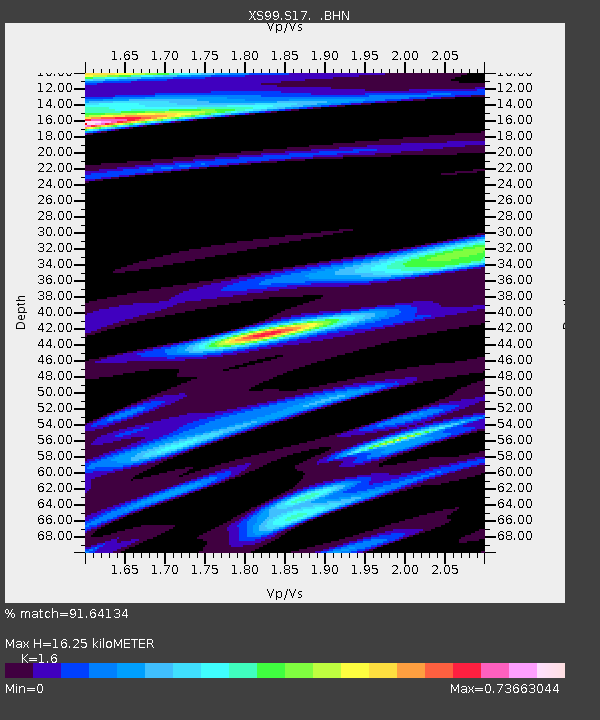
| Estimated Moho Depth: |
16.25 km |
| Estimated Crust Vp/Vs: |
1.60 |
| Assumed Crust Vp: |
6.242 km/s |
| Estimated Crust Vs: |
3.901 km/s |
| Estimated Crust Poisson's Ratio: |
0.18 |
|
| Radial Match: |
91.64134 % |
| Radial Bump: |
400 |
| Transverse Match: |
69.73629 % |
| Transverse Bump: |
400 |
| SOD ConfigId: |
20082 |
| Insert Time: |
2010-03-09 12:35:04.681 +0000 |
| GWidth: |
2.5 |
| Max Bumps: |
400 |
| Tol: |
0.001 |
|

Signal To Noise
| Channel | StoN | STA | LTA |
| XS:S17: :BHN:20000806T07:38:26.975012Z | 5.307144 | 6.362631E-7 | 1.1988804E-7 |
| XS:S17: :BHE:20000806T07:38:26.975012Z | 3.7215326 | 1.0261152E-6 | 2.7572383E-7 |
| XS:S17: :BHZ:20000806T07:38:26.975012Z | 20.04932 | 4.075528E-6 | 2.0327512E-7 |
| Arrivals |
| Ps | 1.6 SECOND |
| PpPs | 6.6 SECOND |
| PsPs/PpSs | 8.2 SECOND |


