
Station XS S17 - XS.S17
Network: XS99 - Montana BB Array
Nearby stations (2 deg radius)
| Station | Name | (Lat, Lon) | Start / End | Elevation |
| S17 | XS.S17 | (45.80, -108.25) | 1999-08-21 / 2000-08-25 | 1800 m |
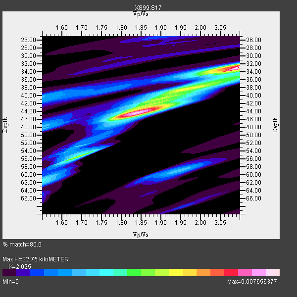
| Crust2 Type: | PD,orogen/50km, Tibet, 2 km seds. |
| Thickness Estimate: | 33 km |
| Thickness StdDev: | 7.3 km |
| Vp/Vs Estimate: | 2.10 |
| Vp/Vs StdDev: | 0.11 |
| Vs Estimate: | 2.979 km/s |
| Poisson's Ratio: | 0.35 |
| Peak Value: | 0.01 |
| Assumed Vp: | 6.242 km/s |
| Ps Weight: | 0.33333334 |
| PpPs Weight: | 0.33333334 |
| PsPs Weight: | 0.33333328 |
| Residual Complexity: | 0.759 |
| Nearby stations H: | +- |
| (2.0 deg) Vp/Vs: | +- |
5 with match > 90% ( 38.46154 %) and 13 with match > 80% ( 100.0 %) out of 13.
Download stack as xyz text file.
Azimuth Distribution of Events:

Prior Results for this Station
| Study | Thickness | Vp/Vs | Vp | Vs | Poissons Ratio | Extra |
| EARS | 33 km | 2.10 | 6.242 km/s | 2.979 km/s | 0.35 | |
| Crust2.0 | 50 km | 1.76 | 6.242 km/s | 3.546 km/s | 0.26 | PD,orogen/50km, Tibet, 2 km seds. |
| Global Maxima | 33 km | 2.10 | 6.242 km/s | 2.979 km/s | 0.35 | amp=0.007656377 |
| Local Maxima 1 | 44 km | 1.84 | 6.242 km/s | 3.392 km/s | 0.29 | amp=0.007185822 |
| Local Maxima 2 | 55 km | 1.70 | 6.242 km/s | 3.666 km/s | 0.24 | amp=0.0029549678 |
| Local Maxima 3 | 37 km | 2.02 | 6.242 km/s | 3.086 km/s | 0.34 | amp=0.0023993617 |
| Local Maxima 4 | 59 km | 1.95 | 6.242 km/s | 3.209 km/s | 0.32 | amp=0.0022049656 |
| Predicted Arrivals for vertical incidence (zero ray parameter) | |
| Ps | 5.75 SECOND |
| PpPs | 16.24 SECOND |
| PsPs/PpSs | 21.98 SECOND |
Events Processed for this Station
Download zip of receiver functions as SAC
Plot maxima for each earthquake.
Events Used in the Stack
(13 events)| Radial Match | Distance | Baz | FERegion | Time | Lat/Lon | Depth | Magnitude |
| 97.060074 | 67.6 deg | 317.59 deg | Sakhalin, Russia | 2000/08/04 21:13:02 GMT | (48.8, 142.2) | 10 km | 6.3 MB, 7.1 MS, 6.8 MW, 6.7 MW |
| 96.18722 | 86.0 deg | 298.045 deg | Volcano Islands, Japan Region | 2000/03/28 11:00:22 GMT | (22.3, 143.7) | 126 km | 6.8 MB, 7.6 MS, 7.6 MW, 7.6 MW |
| 93.74481 | 78.8 deg | 141.421 deg | Jujuy Province, Argentina | 2000/05/12 18:43:18 GMT | (-23.5, -66.5) | 225 km | 6.2 MB, 7.2 MW, 7.1 MW |
| 91.701065 | 86.2 deg | 241.205 deg | Tonga Islands | 2000/01/08 16:47:20 GMT | (-16.9, -174.2) | 183 km | 6.5 MB, 6.6 MS, 7.2 MW, 7.0 ME |
| 91.64134 | 83.6 deg | 305.186 deg | Bonin Islands, Japan Region | 2000/08/06 07:27:12 GMT | (28.9, 139.6) | 395 km | 6.3 MB, 7.3 MW, 7.3 MW |
| 89.89045 | 41.2 deg | 144.346 deg | Off Coast Of Costa Rica | 2000/07/21 01:53:35 GMT | (9.4, -85.3) | 33 km | 5.9 MB, 6.1 MS, 6.4 MW, 5.7 ML |
| 89.18346 | 44.3 deg | 135.557 deg | Panama | 2000/02/26 18:24:39 GMT | (9.4, -78.5) | 65 km | 5.8 MB, 5.4 MS, 6.2 MW, 6.1 MW |
| 88.2945 | 86.5 deg | 149.001 deg | Chile-Argentina Border Region | 2000/06/16 07:55:35 GMT | (-33.9, -70.1) | 120 km | 6.2 MB, 6.5 MW, 6.1 MD |
| 87.709206 | 84.4 deg | 141.003 deg | Santiago Del Estero Prov., Arg. | 2000/04/23 09:27:23 GMT | (-28.3, -63.0) | 608 km | 6.6 MB, 7.0 MW, 7.0 MW |
| 85.47072 | 49.2 deg | 35.62 deg | Iceland | 2000/06/17 15:40:41 GMT | (64.0, -20.5) | 10 km | 5.7 MB, 6.6 MS, 6.8 MW, 6.5 MW |
| 85.1939 | 49.1 deg | 35.663 deg | Iceland | 2000/06/21 00:51:46 GMT | (64.0, -20.8) | 10 km | 6.1 MB, 6.6 MS, 6.5 MW, 6.4 MW |
| 82.972084 | 44.9 deg | 303.666 deg | Andreanof Islands, Aleutian Is. | 2000/04/21 04:35:17 GMT | (51.4, -178.1) | 33 km | 6.0 MB, 5.7 MS, 6.2 ML, 6.0 MW |
| 81.57085 | 87.3 deg | 310.599 deg | Southeast Of Shikoku, Japan | 2000/06/15 11:10:46 GMT | (29.4, 132.1) | 10 km | 6.0 MB, 5.6 MS, 6.1 MW, 6.1 MW |
Losers
(0 events)| Radial Match | Distance | Baz | FERegion | Time | Lat/Lon | Depth | Magnitude | Reason |
