You are here: Home > Network List > XS99 - Montana BB Array Stations List
> Station S18 XS.S18 > Earthquake Result Viewer
S18 XS.S18 - Earthquake Result Viewer
| Earthquake location: |
Iceland |
| Earthquake latitude/longitude: |
64.0/-20.8 |
| Earthquake time(UTC): |
2000/06/21 (173) 00:51:46 GMT |
| Earthquake Depth: |
10 km |
| Earthquake Magnitude: |
6.1 MB, 6.6 MS, 6.5 MW, 6.4 MW |
| Earthquake Catalog/Contributor: |
WHDF/NEIC |
|
| Network: |
XS Montana BB Array |
| Station: |
S18 XS.S18 |
| Lat/Lon: |
45.95 N/109.50 W |
| Elevation: |
1800 m |
|
| Distance: |
49.5 deg |
| Az: |
293.428 deg |
| Baz: |
35.458 deg |
| Ray Param: |
0.06867572 |
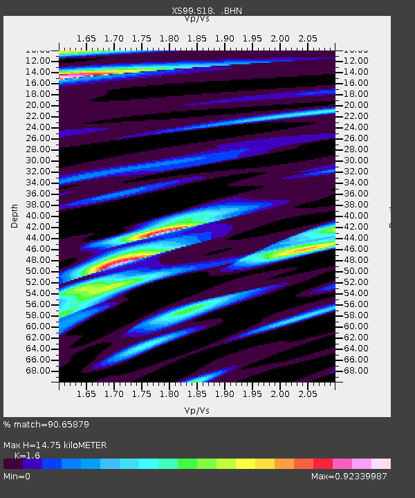
| Estimated Moho Depth: |
14.75 km |
| Estimated Crust Vp/Vs: |
1.60 |
| Assumed Crust Vp: |
6.242 km/s |
| Estimated Crust Vs: |
3.901 km/s |
| Estimated Crust Poisson's Ratio: |
0.18 |
|
| Radial Match: |
90.65879 % |
| Radial Bump: |
400 |
| Transverse Match: |
78.58092 % |
| Transverse Bump: |
400 |
| SOD ConfigId: |
20082 |
| Insert Time: |
2010-03-09 12:35:36.754 +0000 |
| GWidth: |
2.5 |
| Max Bumps: |
400 |
| Tol: |
0.001 |
|

Signal To Noise
| Channel | StoN | STA | LTA |
| XS:S18: :BHN:20000621T01:00:06.300013Z | 3.5077324 | 1.2059169E-6 | 3.4378817E-7 |
| XS:S18: :BHE:20000621T01:00:06.300013Z | 4.1653333 | 7.766411E-7 | 1.8645352E-7 |
| XS:S18: :BHZ:20000621T01:00:06.300013Z | 17.358988 | 2.5881861E-6 | 1.4909776E-7 |
| Arrivals |
| Ps | 1.5 SECOND |
| PpPs | 5.8 SECOND |
| PsPs/PpSs | 7.3 SECOND |


