
Station XS S18 - XS.S18
Network: XS99 - Montana BB Array
Nearby stations (2 deg radius)

| Station | Name | (Lat, Lon) | Start / End | Elevation |
| S18 | XS.S18 | (45.95, -109.50) | 1999-08-21 / 2000-08-25 | 1800 m |
| Crust2 Type: | PD,orogen/50km, Tibet, 2 km seds. |
| Thickness Estimate: | 50 km |
| Thickness StdDev: | 2.6 km |
| Vp/Vs Estimate: | 1.80 |
| Vp/Vs StdDev: | 0.06 |
| Vs Estimate: | 3.473 km/s |
| Poisson's Ratio: | 0.28 |
| Peak Value: | 0.02 |
| Assumed Vp: | 6.242 km/s |
| Ps Weight: | 0.33333334 |
| PpPs Weight: | 0.33333334 |
| PsPs Weight: | 0.33333328 |
| Residual Complexity: | 0.778 |
| Nearby stations H: | +- |
| (2.0 deg) Vp/Vs: | +- |
5 with match > 90% ( 31.25 %) and 16 with match > 80% ( 100.0 %) out of 16.
Download stack as xyz text file.
Azimuth Distribution of Events:

Prior Results for this Station
| Study | Thickness | Vp/Vs | Vp | Vs | Poissons Ratio | Extra |
| EARS | 50 km | 1.80 | 6.242 km/s | 3.473 km/s | 0.28 | |
| Crust2.0 | 50 km | 1.76 | 6.242 km/s | 3.546 km/s | 0.26 | PD,orogen/50km, Tibet, 2 km seds. |
| Global Maxima | 50 km | 1.80 | 6.242 km/s | 3.473 km/s | 0.28 | amp=0.017268073 |
| Local Maxima 1 | 47 km | 1.80 | 6.242 km/s | 3.477 km/s | 0.27 | amp=0.0155485105 |
| Local Maxima 2 | 45 km | 1.84 | 6.242 km/s | 3.392 km/s | 0.29 | amp=0.010894682 |
| Local Maxima 3 | 49 km | 1.69 | 6.242 km/s | 3.699 km/s | 0.23 | amp=0.007915973 |
| Local Maxima 4 | 43 km | 2.10 | 6.242 km/s | 2.976 km/s | 0.35 | amp=0.006904584 |
| Predicted Arrivals for vertical incidence (zero ray parameter) | |
| Ps | 6.45 SECOND |
| PpPs | 22.63 SECOND |
| PsPs/PpSs | 29.08 SECOND |
Events Processed for this Station
Download zip of receiver functions as SAC
Plot maxima for each earthquake.
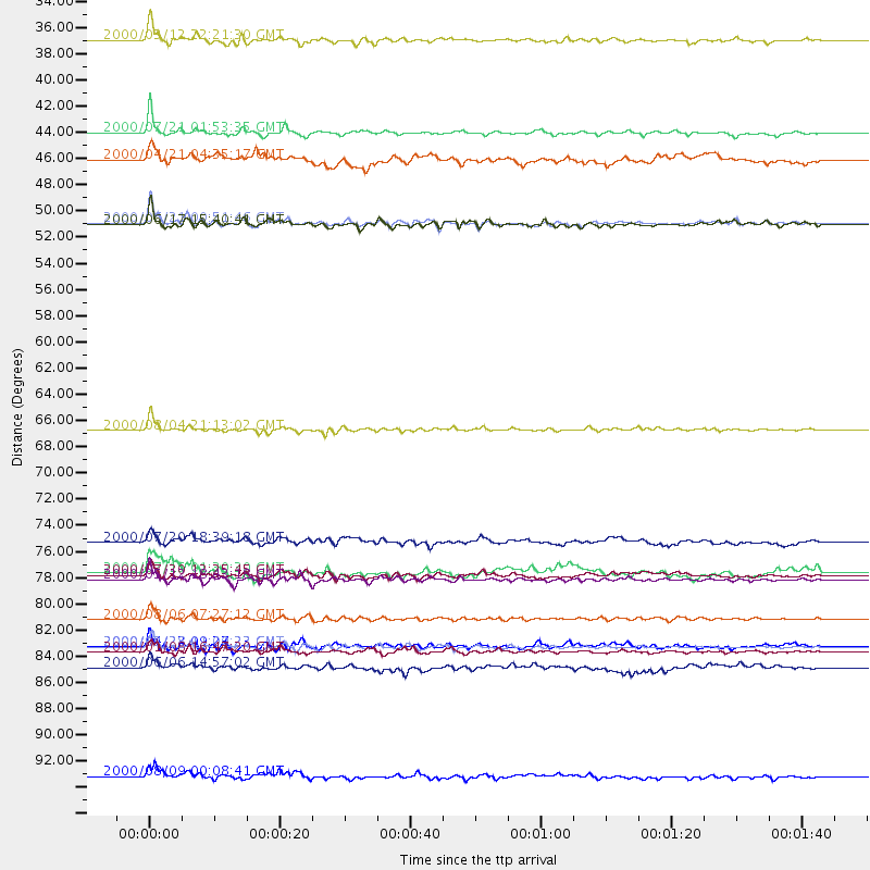
Events Used in the Stack
(16 events)| Radial Match | Distance | Baz | FERegion | Time | Lat/Lon | Depth | Magnitude |
| 96.9815 | 85.2 deg | 297.172 deg | Volcano Islands, Japan Region | 2000/03/28 11:00:22 GMT | (22.3, 143.7) | 126 km | 6.8 MB, 7.6 MS, 7.6 MW, 7.6 MW |
| 95.428154 | 41.9 deg | 142.765 deg | Off Coast Of Costa Rica | 2000/07/21 01:53:35 GMT | (9.4, -85.3) | 33 km | 5.9 MB, 6.1 MS, 6.4 MW, 5.7 ML |
| 94.75961 | 79.4 deg | 140.416 deg | Jujuy Province, Argentina | 2000/05/12 18:43:18 GMT | (-23.5, -66.5) | 225 km | 6.2 MB, 7.2 MW, 7.1 MW |
| 94.68627 | 66.9 deg | 316.922 deg | Sakhalin, Russia | 2000/08/04 21:13:02 GMT | (48.8, 142.2) | 10 km | 6.3 MB, 7.1 MS, 6.8 MW, 6.7 MW |
| 90.65879 | 49.5 deg | 35.458 deg | Iceland | 2000/06/21 00:51:46 GMT | (64.0, -20.8) | 10 km | 6.1 MB, 6.6 MS, 6.5 MW, 6.4 MW |
| 87.88181 | 85.1 deg | 140.057 deg | Santiago Del Estero Prov., Arg. | 2000/04/23 09:27:23 GMT | (-28.3, -63.0) | 608 km | 6.6 MB, 7.0 MW, 7.0 MW |
| 87.38819 | 82.8 deg | 304.337 deg | Bonin Islands, Japan Region | 2000/08/06 07:27:12 GMT | (28.9, 139.6) | 395 km | 6.3 MB, 7.3 MW, 7.3 MW |
| 86.8264 | 79.1 deg | 307.813 deg | Southeast Of Honshu, Japan | 2000/07/30 12:25:45 GMT | (33.9, 139.4) | 10 km | 6.0 MB, 6.5 MS, 6.5 MW, 6.5 MW |
| 86.644615 | 85.6 deg | 240.272 deg | Tonga Islands | 2000/01/08 16:47:20 GMT | (-16.9, -174.2) | 183 km | 6.5 MB, 6.6 MS, 7.2 MW, 7.0 ME |
| 85.899765 | 49.6 deg | 35.412 deg | Iceland | 2000/06/17 15:40:41 GMT | (64.0, -20.5) | 10 km | 5.7 MB, 6.6 MS, 6.8 MW, 6.5 MW |
| 83.926254 | 76.3 deg | 308.597 deg | Near East Coast Of Honshu, Japan | 2000/07/20 18:39:18 GMT | (36.5, 141.0) | 47 km | 6.1 MB, 5.4 MS, 6.1 ME, 6.0 MW |
| 83.47161 | 34.0 deg | 149.586 deg | Near Coast Of Chiapas, Mexico | 2000/03/12 22:21:30 GMT | (15.0, -92.4) | 62 km | 5.5 MB, 5.8 MS, 6.3 MW, 5.4 MD |
| 82.73459 | 96.0 deg | 253.802 deg | Vanuatu Islands | 2000/08/09 00:08:41 GMT | (-15.7, 168.0) | 33 km | 6.3 MB, 6.0 MS, 6.4 MW, 6.3 MW |
| 80.44539 | 44.1 deg | 303.13 deg | Andreanof Islands, Aleutian Is. | 2000/04/21 04:35:17 GMT | (51.4, -178.1) | 33 km | 6.0 MB, 5.7 MS, 6.2 ML, 6.0 MW |
| 80.37658 | 86.9 deg | 310.221 deg | Southeast Of Ryukyu Islands | 2000/06/06 14:57:02 GMT | (29.4, 131.4) | 33 km | 5.8 MB, 6.0 MS, 6.4 MW, 6.4 MW |
| 80.22989 | 78.9 deg | 308.168 deg | Near S. Coast Of Honshu, Japan | 2000/07/15 01:30:30 GMT | (34.3, 139.3) | 10 km | 5.5 MB, 5.9 MS, 6.1 MW, 6.0 MW |
Losers
(0 events)| Radial Match | Distance | Baz | FERegion | Time | Lat/Lon | Depth | Magnitude | Reason |
