You are here: Home > Network List > XS99 - Montana BB Array Stations List
> Station S18 XS.S18 > Earthquake Result Viewer
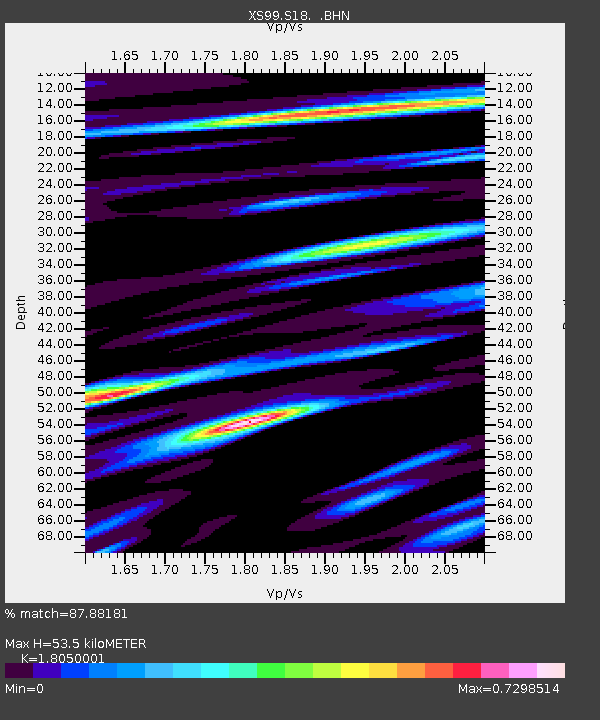
S18 XS.S18 - Earthquake Result Viewer
| Earthquake location: |
Santiago Del Estero Prov., Arg. |
| Earthquake latitude/longitude: |
-28.3/-63.0 |
| Earthquake time(UTC): |
2000/04/23 (114) 09:27:23 GMT |
| Earthquake Depth: |
608 km |
| Earthquake Magnitude: |
6.6 MB, 7.0 MW, 7.0 MW |
| Earthquake Catalog/Contributor: |
WHDF/NEIC |
|
| Network: |
XS Montana BB Array |
| Station: |
S18 XS.S18 |
| Lat/Lon: |
45.95 N/109.50 W |
| Elevation: |
1800 m |
|
| Distance: |
85.1 deg |
| Az: |
329.471 deg |
| Baz: |
140.057 deg |
| Ray Param: |
0.0432224 |
| Estimated Moho Depth: |
53.5 km |
| Estimated Crust Vp/Vs: |
1.81 |
| Assumed Crust Vp: |
6.242 km/s |
| Estimated Crust Vs: |
3.458 km/s |
| Estimated Crust Poisson's Ratio: |
0.28 |
|
| Radial Match: |
87.88181 % |
| Radial Bump: |
400 |
| Transverse Match: |
80.24932 % |
| Transverse Bump: |
400 |
| SOD ConfigId: |
20082 |
| Insert Time: |
2010-03-09 12:35:41.051 +0000 |
| GWidth: |
2.5 |
| Max Bumps: |
400 |
| Tol: |
0.001 |
|

Signal To Noise
| Channel | StoN | STA | LTA |
| XS:S18: :BHN:20000423T09:38:24.999016Z | 3.8228755 | 1.8828975E-6 | 4.9253435E-7 |
| XS:S18: :BHE:20000423T09:38:24.999016Z | 7.1189513 | 2.5829813E-6 | 3.6283174E-7 |
| XS:S18: :BHZ:20000423T09:38:24.999016Z | 30.598095 | 1.16841875E-5 | 3.8185996E-7 |
| Arrivals |
| Ps | 7.0 SECOND |
| PpPs | 24 SECOND |
| PsPs/PpSs | 31 SECOND |


