You are here: Home > Network List > XS99 - Montana BB Array Stations List
> Station S18 XS.S18 > Earthquake Result Viewer
S18 XS.S18 - Earthquake Result Viewer
| Earthquake location: |
Tonga Islands |
| Earthquake latitude/longitude: |
-16.9/-174.2 |
| Earthquake time(UTC): |
2000/01/08 (008) 16:47:20 GMT |
| Earthquake Depth: |
183 km |
| Earthquake Magnitude: |
6.5 MB, 6.6 MS, 7.2 MW, 7.0 ME |
| Earthquake Catalog/Contributor: |
WHDF/NEIC |
|
| Network: |
XS Montana BB Array |
| Station: |
S18 XS.S18 |
| Lat/Lon: |
45.95 N/109.50 W |
| Elevation: |
1800 m |
|
| Distance: |
85.6 deg |
| Az: |
39.264 deg |
| Baz: |
240.272 deg |
| Ray Param: |
0.044258654 |
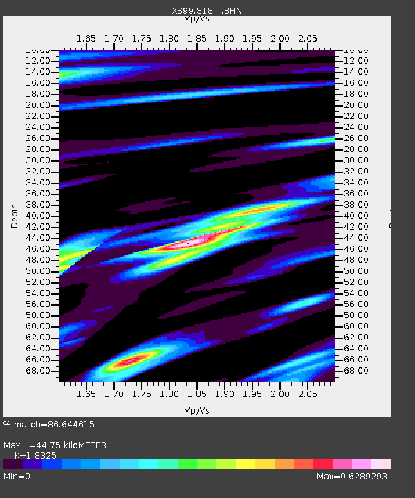
| Estimated Moho Depth: |
44.75 km |
| Estimated Crust Vp/Vs: |
1.83 |
| Assumed Crust Vp: |
6.242 km/s |
| Estimated Crust Vs: |
3.406 km/s |
| Estimated Crust Poisson's Ratio: |
0.29 |
|
| Radial Match: |
86.644615 % |
| Radial Bump: |
400 |
| Transverse Match: |
73.26223 % |
| Transverse Bump: |
400 |
| SOD ConfigId: |
20082 |
| Insert Time: |
2010-03-09 12:35:47.353 +0000 |
| GWidth: |
2.5 |
| Max Bumps: |
400 |
| Tol: |
0.001 |
|

Signal To Noise
| Channel | StoN | STA | LTA |
| XS:S18: :BHN:20000108T16:59:06.798018Z | 1.202192 | 1.0770201E-6 | 8.9588025E-7 |
| XS:S18: :BHE:20000108T16:59:06.798018Z | 1.9494969 | 1.5588604E-6 | 7.996219E-7 |
| XS:S18: :BHZ:20000108T16:59:06.798018Z | 11.964826 | 8.416018E-6 | 7.033966E-7 |
| Arrivals |
| Ps | 6.1 SECOND |
| PpPs | 20 SECOND |
| PsPs/PpSs | 26 SECOND |


