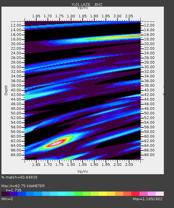
LAZE YL.LAZE - Earthquake Result Viewer
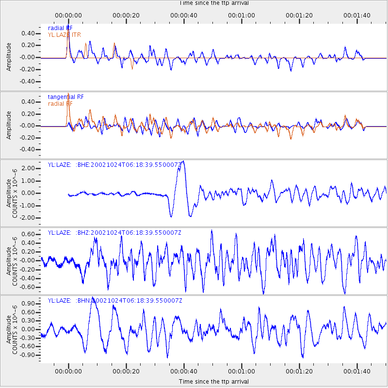
Earthquake location: Lake Tanganyika Region
Earthquake latitude/longitude: -1.9/29.0
Earthquake time(UTC): 2002/10/24 (297) 06:08:37 GMT
Earthquake Depth: 11 km
Earthquake Magnitude: 5.9 MB, 6.3 MS, 6.2 MW, 6.1 MW
Earthquake Catalog/Contributor: WHDF/NEIC
Network: YL Himalayan Nepal Tibet Experiment
Station: LAZE YL.LAZE
Lat/Lon: 29.14 N/87.59 E
Elevation: 4011 m
Distance: 63.9 deg
Az: 56.238 deg
Baz: 251.771 deg
Ray Param: 0.05926983
Estimated Moho Depth: 62.75 km
Estimated Crust Vp/Vs: 1.74
Assumed Crust Vp: 6.514 km/s
Estimated Crust Vs: 3.755 km/s
Estimated Crust Poisson's Ratio: 0.25
Radial Match: 80.64935 %
Radial Bump: 400
Transverse Match: 74.54095 %
Transverse Bump: 400
SOD ConfigId: 16820
Insert Time: 2010-02-26 15:58:34.749 +0000
GWidth: 2.5
Max Bumps: 400
Tol: 0.001

Signal To Noise

ChannelStoNSTALTA
YL:LAZE: :BHZ:20021024T06:18:39.550007Z2.30935451.3567681E-75.8750963E-8
YL:LAZE: :BHN:20021024T06:18:39.550007Z1.26258991.1752942E-79.308598E-8
YL:LAZE: :BHE:20021024T06:18:39.550007Z2.15323142.014217E-79.354392E-8
Arrivals
Ps7.4 SECOND
PpPs25 SECOND
PsPs/PpSs33 SECOND