
Station YL LAZE - YL.LAZE
Network: YL01 - Himalayan Nepal Tibet Experiment
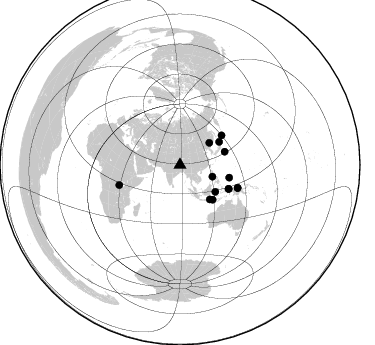
Nearby stations (2 deg radius)
| Station | Name | (Lat, Lon) | Start / End | Elevation |
| LAZE | YL.LAZE | (29.14, 87.59) | 2001-09-07 / 2003-01-01 | 4011 m |
| Crust2 Type: | RD,orogen/70km Tibet, no seds. |
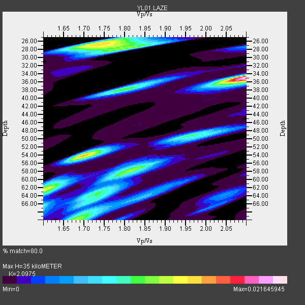
| Thickness Estimate: | 35 km |
| Thickness StdDev: | 13 km |
| Vp/Vs Estimate: | 2.10 |
| Vp/Vs StdDev: | 0.19 |
| Vs Estimate: | 3.106 km/s |
| Poisson's Ratio: | 0.35 |
| Peak Value: | 0.02 |
| Assumed Vp: | 6.514 km/s |
| Ps Weight: | 0.33333334 |
| PpPs Weight: | 0.33333334 |
| PsPs Weight: | 0.33333328 |
| Residual Complexity: | 0.889 |
| Nearby stations H: | +- |
| (2.0 deg) Vp/Vs: | +- |
2 with match > 90% ( 7.142857 %) and 14 with match > 80% ( 50.0 %) out of 28.
Download stack as xyz text file.
Azimuth Distribution of Events:
Prior Results for this Station
| Study | Thickness | Vp/Vs | Vp | Vs | Poissons Ratio | Extra |
| EARS | 35 km | 2.10 | 6.514 km/s | 3.106 km/s | 0.35 | |
| Crust2.0 | 70 km | 1.76 | 6.514 km/s | 3.706 km/s | 0.26 | RD,orogen/70km Tibet, no seds. |
| Global Maxima | 35 km | 2.10 | 6.514 km/s | 3.106 km/s | 0.35 | amp=0.021645945 |
| Local Maxima 1 | 54 km | 1.70 | 6.514 km/s | 3.843 km/s | 0.23 | amp=0.015160977 |
| Local Maxima 2 | 26 km | 1.74 | 6.514 km/s | 3.738 km/s | 0.25 | amp=0.014972654 |
| Local Maxima 3 | 58 km | 1.81 | 6.514 km/s | 3.599 km/s | 0.28 | amp=0.012181169 |
| Local Maxima 4 | 28 km | 1.81 | 6.514 km/s | 3.599 km/s | 0.28 | amp=0.01014388 |
| Predicted Arrivals for vertical incidence (zero ray parameter) | |
| Ps | 5.90 SECOND |
| PpPs | 16.64 SECOND |
| PsPs/PpSs | 22.54 SECOND |
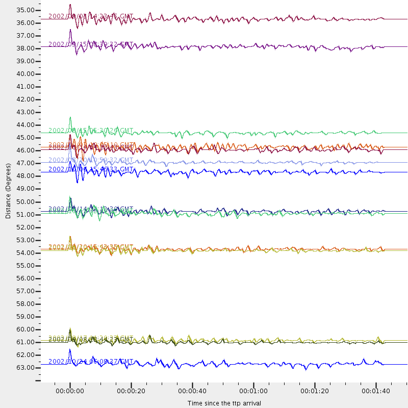
Events Processed for this Station
Download zip of receiver functions as SAC
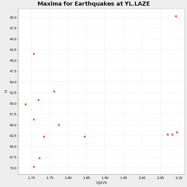
Plot maxima for each earthquake.
Events Used in the Stack
(14 events)| Radial Match | Distance | Baz | FERegion | Time | Lat/Lon | Depth | Magnitude |
| 96.46239 | 62.0 deg | 111.59 deg | Near N Coast Of New Guinea, P.N.G. | 2002/09/08 18:44:23 GMT | (-3.3, 142.9) | 13 km | 6.5 MB, 7.8 MS, 7.6 MW, 7.3 MW |
| 90.151596 | 54.2 deg | 116.247 deg | Irian Jaya Region, Indonesia | 2002/10/10 10:50:20 GMT | (-1.8, 134.3) | 10 km | 6.5 MB, 7.7 MS, 7.6 MW, 7.4 MW |
| 89.929344 | 51.1 deg | 54.876 deg | Kuril Islands | 2002/10/19 12:09:05 GMT | (44.3, 150.0) | 33 km | 5.4 MB, 6.2 MS, 6.4 MW, 6.1 MW |
| 88.5625 | 46.7 deg | 73.573 deg | Southeast Of Honshu, Japan | 2002/08/20 10:59:32 GMT | (31.0, 142.0) | 9.0 km | 5.4 MB, 6.2 MS, 6.3 MW, 6.1 MW |
| 87.40615 | 47.5 deg | 136.646 deg | Sumbawa Region, Indonesia | 2002/10/06 15:46:33 GMT | (-8.2, 118.3) | 10 km | 5.8 MB, 6.0 MS, 6.2 MW, 6.2 MW |
| 87.10218 | 45.4 deg | 139.05 deg | Bali Sea | 2002/10/03 19:05:10 GMT | (-7.5, 115.7) | 316 km | 6.0 MB, 6.0 MW, 6.0 MW |
| 85.556816 | 54.1 deg | 116.221 deg | Irian Jaya Region, Indonesia | 2002/09/20 15:43:35 GMT | (-1.7, 134.2) | 10 km | 5.9 MB, 6.4 MS, 6.4 MW, 6.3 MW |
| 85.217415 | 44.2 deg | 127.16 deg | Sulawesi, Indonesia | 2002/08/15 05:30:26 GMT | (-1.2, 121.3) | 10 km | 5.7 MB, 5.8 MS, 6.2 MW, 6.1 MW |
| 83.80822 | 45.6 deg | 59.537 deg | Hokkaido, Japan Region | 2002/10/14 14:12:43 GMT | (41.2, 142.2) | 61 km | 5.9 MB, 6.1 MW, 6.1 MW |
| 81.3903 | 34.4 deg | 109.746 deg | Mindoro, Philippines | 2002/09/03 14:23:45 GMT | (13.5, 120.8) | 10 km | 5.5 MB, 5.4 MS, 5.9 MW, 5.8 MW |
| 81.32337 | 36.8 deg | 53.092 deg | Northeastern China | 2002/09/15 08:39:32 GMT | (44.8, 129.9) | 586 km | 5.8 MB, 6.4 MW, 6.4 MW |
| 80.64935 | 63.9 deg | 251.771 deg | Lake Tanganyika Region | 2002/10/24 06:08:37 GMT | (-1.9, 29.0) | 11 km | 5.9 MB, 6.3 MS, 6.2 MW, 6.1 MW |
| 80.0533 | 61.9 deg | 111.689 deg | Near N Coast Of New Guinea, P.N.G. | 2002/09/17 11:20:23 GMT | (-3.3, 142.8) | 10 km | 5.7 MB, 5.9 MS, 6.1 MW, 6.0 MW |
| 80.03135 | 50.9 deg | 104.532 deg | W. Caroline Islands, Micronesia | 2002/08/14 13:12:39 GMT | (7.8, 136.9) | 10 km | 6.1 MB, 6.0 MS, 6.3 MW, 6.3 MW |
Losers
(14 events)| Radial Match | Distance | Baz | FERegion | Time | Lat/Lon | Depth | Magnitude | Reason |
| 82.873924 | 39.7 deg | 151.105 deg | Sunda Strait, Indonesia | 2002/08/26 14:55:13 GMT | (-6.8, 105.7) | 63 km | 5.6 MB, 5.8 MW, 5.7 MW | |
| 79.45616 | 54.1 deg | 116.26 deg | Irian Jaya Region, Indonesia | 2002/10/10 11:05:15 GMT | (-1.7, 134.2) | 10 km | 5.5 MB | |
| 78.85653 | 48.4 deg | 56.688 deg | Kuril Islands | 2002/08/24 18:40:53 GMT | (43.1, 146.1) | 43 km | 5.9 MB, 5.8 MS, 6.2 MW, 6.1 MW | |
| 78.350784 | 32.6 deg | 250.798 deg | Arabian Sea | 2002/08/13 08:37:22 GMT | (14.7, 55.8) | 10 km | 5.8 MB, 5.5 MS, 5.8 MW, 5.6 MW | |
| 78.2344 | 31.0 deg | 89.028 deg | Taiwan Region | 2002/09/16 00:03:29 GMT | (25.2, 122.3) | 183 km | 5.6 MW, 5.3 MB, 5.5 MW | |
| 75.85958 | 81.2 deg | 107.367 deg | Solomon Islands | 2002/09/24 23:01:28 GMT | (-10.6, 161.2) | 19 km | 5.7 MB, 6.5 MS, 6.3 MW, 6.3 MW | |
| 75.73887 | 36.1 deg | 253.517 deg | Eastern Gulf Of Aden | 2002/09/01 17:14:59 GMT | (14.3, 51.9) | 10 km | 5.8 MS, 5.2 MB, 6.0 MW, 6.0 MW | |
| 74.50257 | 48.5 deg | 137.233 deg | Sumbawa Region, Indonesia | 2002/07/24 03:05:05 GMT | (-9.3, 118.6) | 29 km | 5.8 MB, 5.4 MS, 5.9 MW, 5.9 MW | |
| 72.731674 | 31.7 deg | 109.434 deg | Philippine Islands Region | 2002/10/12 23:43:12 GMT | (15.1, 118.5) | 33 km | 5.6 MB, 5.6 MS, 6.1 MW | |
| 71.56257 | 64.4 deg | 109.834 deg | Near N Coast Of New Guinea, P.N.G. | 2002/08/29 05:36:54 GMT | (-3.4, 145.8) | 33 km | 5.7 MS, 5.2 MB, 5.9 MW, 5.8 MW | |
| 58.79647 | 53.9 deg | 116.107 deg | Irian Jaya Region, Indonesia | 2002/10/10 18:33:37 GMT | (-1.5, 134.1) | 10 km | 5.5 MS, 5.4 MB | |
| 54.881958 | 53.9 deg | 116.12 deg | Irian Jaya Region, Indonesia | 2002/10/10 21:19:58 GMT | (-1.5, 134.1) | 10 km | 5.8 MB, 5.7 MS, 6.0 MW | |
| 53.24413 | 54.3 deg | 123.849 deg | Banda Sea | 2002/07/30 20:02:06 GMT | (-6.5, 130.3) | 103 km | 5.5 MW, 5.4 MB, 5.3 MW | |
| 39.043255 | 55.4 deg | 44.866 deg | Near East Coast Of Kamchatka | 2002/10/16 10:12:21 GMT | (52.0, 157.3) | 102 km | 6.1 MB, 6.2 MW, 6.2 MW |
