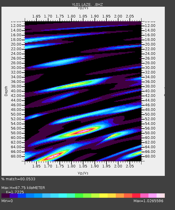
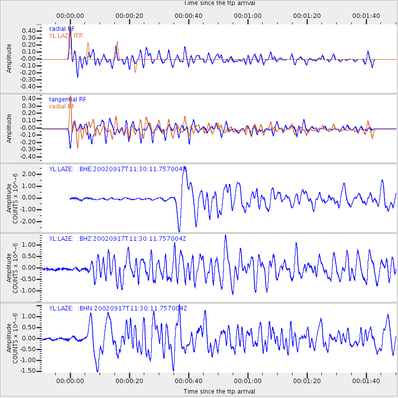
LAZE YL.LAZE - Earthquake Result Viewer

Earthquake location: Near N Coast Of New Guinea, P.N.G.
Earthquake latitude/longitude: -3.3/142.8
Earthquake time(UTC): 2002/09/17 (260) 11:20:23 GMT
Earthquake Depth: 10 km
Earthquake Magnitude: 5.7 MB, 5.9 MS, 6.1 MW, 6.0 MW
Earthquake Catalog/Contributor: WHDF/NEIC
Network: YL Himalayan Nepal Tibet Experiment
Station: LAZE YL.LAZE
Lat/Lon: 29.14 N/87.59 E
Elevation: 4011 m
Distance: 61.9 deg
Az: 305.492 deg
Baz: 111.689 deg
Ray Param: 0.060587447
Estimated Moho Depth: 67.75 km
Estimated Crust Vp/Vs: 1.72
Assumed Crust Vp: 6.514 km/s
Estimated Crust Vs: 3.782 km/s
Estimated Crust Poisson's Ratio: 0.25
Radial Match: 80.0533 %
Radial Bump: 400
Transverse Match: 84.91414 %
Transverse Bump: 400
SOD ConfigId: 16820
Insert Time: 2010-02-26 15:58:38.103 +0000
GWidth: 2.5
Max Bumps: 400
Tol: 0.001

Signal To Noise

ChannelStoNSTALTA
YL:LAZE: :BHZ:20020917T11:30:11.757004Z1.19659058.6608885E-87.237971E-8
YL:LAZE: :BHN:20020917T11:30:11.757004Z0.91838277.210916E-87.851755E-8
YL:LAZE: :BHE:20020917T11:30:11.757004Z1.67296549.513712E-85.6867353E-8
Arrivals
Ps7.9 SECOND
PpPs27 SECOND
PsPs/PpSs35 SECOND