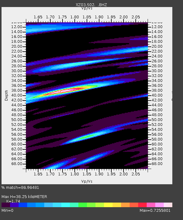
S02 Ghado - Earthquake Result Viewer

Earthquake location: Talaud Islands, Indonesia
Earthquake latitude/longitude: 3.7/128.0
Earthquake time(UTC): 2003/05/05 (125) 23:04:45 GMT
Earthquake Depth: 56 km
Earthquake Magnitude: 6.0 MB, 5.7 MS, 6.1 MW, 6.1 MW
Earthquake Catalog/Contributor: WHDF/NEIC
Network: XZ DHOFAR Seismic Experiment
Station: S02 Ghado
Lat/Lon: 17.13 N/54.00 E
Elevation: 788 m
Distance: 73.6 deg
Az: 286.663 deg
Baz: 91.145 deg
Ray Param: 0.052791025
Estimated Moho Depth: 38.25 km
Estimated Crust Vp/Vs: 1.74
Assumed Crust Vp: 6.47 km/s
Estimated Crust Vs: 3.719 km/s
Estimated Crust Poisson's Ratio: 0.25
Radial Match: 86.96481 %
Radial Bump: 390
Transverse Match: 82.24755 %
Transverse Bump: 400
SOD ConfigId: 16844
Insert Time: 2010-03-09 12:38:14.111 +0000
GWidth: 2.5
Max Bumps: 400
Tol: 0.001

Signal To Noise

ChannelStoNSTALTA
XZ:S02: :BHZ:20030505T23:15:41.979021Z11.4530831.05262E-69.1907125E-8
XZ:S02: :BHN:20030505T23:15:41.979021Z1.34528049.144276E-86.797301E-8
XZ:S02: :BHE:20030505T23:15:41.979021Z6.4585683.558623E-75.5099257E-8
Arrivals
Ps4.5 SECOND
PpPs16 SECOND
PsPs/PpSs20 SECOND