
Station XZ S02 - Ghado
Network: XZ03 - DHOFAR Seismic Experiment
Nearby stations (2 deg radius)
| Station | Name | (Lat, Lon) | Start / End | Elevation |
| S02 | Ghado | (17.13, 54.00) | 2003-03-18 / 2004-03-18 | 788 m |
| Crust2 Type: | T9,thin Margin /shield transition, 1 km seds. |
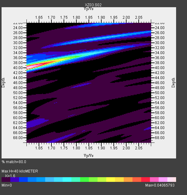
| Thickness Estimate: | 40 km |
| Thickness StdDev: | 2.2 km |
| Vp/Vs Estimate: | 1.60 |
| Vp/Vs StdDev: | 0.05 |
| Vs Estimate: | 4.044 km/s |
| Poisson's Ratio: | 0.18 |
| Peak Value: | 0.04 |
| Assumed Vp: | 6.47 km/s |
| Ps Weight: | 0.33333334 |
| PpPs Weight: | 0.33333334 |
| PsPs Weight: | 0.33333328 |
| Residual Complexity: | 0.591 |
| Nearby stations H: | +- |
| (2.0 deg) Vp/Vs: | +- |
1 with match > 90% ( 16.666666 %) and 5 with match > 80% ( 83.333336 %) out of 6.
Download stack as xyz text file.
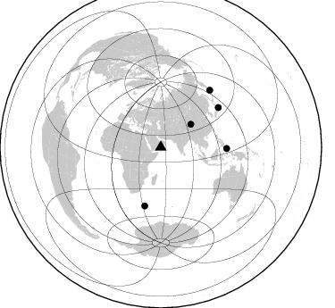
Azimuth Distribution of Events:
Prior Results for this Station
| Study | Thickness | Vp/Vs | Vp | Vs | Poissons Ratio | Extra |
| EARS | 40 km | 1.60 | 6.47 km/s | 4.044 km/s | 0.18 | |
| Crust2.0 | 27 km | 1.79 | 6.47 km/s | 3.619 km/s | 0.27 | T9,thin Margin /shield transition, 1 km seds. |
| Global Maxima | 40 km | 1.60 | 6.47 km/s | 4.044 km/s | 0.18 | amp=0.04065793 |
| Local Maxima 1 | 37 km | 1.73 | 6.47 km/s | 3.751 km/s | 0.25 | amp=0.019635465 |
| Local Maxima 2 | 28 km | 1.88 | 6.47 km/s | 3.433 km/s | 0.30 | amp=0.0109779 |
| Local Maxima 3 | 22 km | 1.93 | 6.47 km/s | 3.348 km/s | 0.32 | amp=0.007853589 |
| Local Maxima 4 | 34 km | 1.88 | 6.47 km/s | 3.451 km/s | 0.30 | amp=0.0075337472 |
| Predicted Arrivals for vertical incidence (zero ray parameter) | |
| Ps | 3.71 SECOND |
| PpPs | 16.07 SECOND |
| PsPs/PpSs | 19.78 SECOND |
Events Processed for this Station
Download zip of receiver functions as SAC
Plot maxima for each earthquake.
Events Used in the Stack
(5 events)| Radial Match | Distance | Baz | FERegion | Time | Lat/Lon | Depth | Magnitude |
| 91.00961 | 84.3 deg | 40.746 deg | Kuril Islands | 2003/04/24 10:56:21 GMT | (48.8, 155.0) | 44 km | 5.6 MB, 5.7 MS, 6.1 MW, 6.0 MW |
| 88.37375 | 42.4 deg | 52.739 deg | Qinghai, China | 2003/04/17 00:48:38 GMT | (37.5, 96.5) | 14 km | 6.2 MB, 6.3 MS, 6.4 MW, 6.2 MW |
| 87.12045 | 67.9 deg | 195.502 deg | Prince Edward Islands Region | 2003/05/09 20:26:15 GMT | (-48.2, 32.3) | 10 km | 5.5 MB, 6.1 MS, 6.3 MW, 6.2 MW |
| 86.96481 | 73.6 deg | 91.145 deg | Talaud Islands, Indonesia | 2003/05/05 23:04:45 GMT | (3.7, 128.0) | 56 km | 6.0 MB, 5.7 MS, 6.1 MW, 6.1 MW |
| 83.62186 | 78.2 deg | 55.537 deg | Near East Coast Of Honshu, Japan | 2003/04/07 18:28:37 GMT | (36.3, 141.7) | 33 km | 5.5 MB, 5.5 MS, 5.9 MW, 5.8 MW |
Losers
(1 events)| Radial Match | Distance | Baz | FERegion | Time | Lat/Lon | Depth | Magnitude | Reason |
| 72.49911 | 81.1 deg | 47.097 deg | Kuril Islands | 2003/04/29 13:53:17 GMT | (43.7, 147.8) | 62 km | 6.0 MB, 6.0 MW, 5.9 MW |
