You are here: Home > Network List > XZ03 - DHOFAR Seismic Experiment Stations List
> Station S05 Haluf > Earthquake Result Viewer
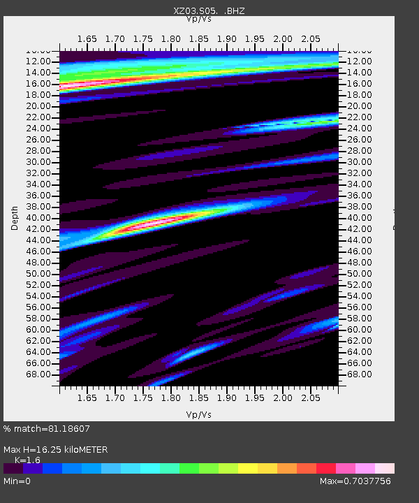
S05 Haluf - Earthquake Result Viewer
| Earthquake location: |
Flores Region, Indonesia |
| Earthquake latitude/longitude: |
-8.3/120.7 |
| Earthquake time(UTC): |
2003/03/25 (084) 02:53:25 GMT |
| Earthquake Depth: |
33 km |
| Earthquake Magnitude: |
6.2 MB, 6.1 MS, 6.5 MW, 6.3 MW |
| Earthquake Catalog/Contributor: |
WHDF/NEIC |
|
| Network: |
XZ DHOFAR Seismic Experiment |
| Station: |
S05 Haluf |
| Lat/Lon: |
17.35 N/53.97 E |
| Elevation: |
680 m |
|
| Distance: |
70.7 deg |
| Az: |
291.593 deg |
| Baz: |
105.52 deg |
| Ray Param: |
0.054748565 |
| Estimated Moho Depth: |
16.25 km |
| Estimated Crust Vp/Vs: |
1.60 |
| Assumed Crust Vp: |
6.47 km/s |
| Estimated Crust Vs: |
4.044 km/s |
| Estimated Crust Poisson's Ratio: |
0.18 |
|
| Radial Match: |
81.18607 % |
| Radial Bump: |
400 |
| Transverse Match: |
73.37486 % |
| Transverse Bump: |
400 |
| SOD ConfigId: |
16844 |
| Insert Time: |
2010-03-09 12:38:34.586 +0000 |
| GWidth: |
2.5 |
| Max Bumps: |
400 |
| Tol: |
0.001 |
|

Signal To Noise
| Channel | StoN | STA | LTA |
| XZ:S05: :BHZ:20030325T03:04:06.780Z | 5.890995 | 4.688347E-7 | 7.958498E-8 |
| XZ:S05: :BHN:20030325T03:04:06.780Z | 0.932292 | 1.2023321E-7 | 1.2896518E-7 |
| XZ:S05: :BHE:20030325T03:04:06.780Z | 1.0822587 | 2.0728892E-7 | 1.9153362E-7 |
| Arrivals |
| Ps | 1.6 SECOND |
| PpPs | 6.3 SECOND |
| PsPs/PpSs | 7.8 SECOND |


