
Station XZ S05 - Haluf
Network: XZ03 - DHOFAR Seismic Experiment
Nearby stations (2 deg radius)
| Station | Name | (Lat, Lon) | Start / End | Elevation |
| S05 | Haluf | (17.35, 53.97) | 2003-03-19 / 2003-08-24 | 680 m |
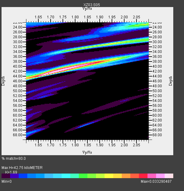
| Crust2 Type: | T9,thin Margin /shield transition, 1 km seds. |
| Thickness Estimate: | 43 km |
| Thickness StdDev: | 8.5 km |
| Vp/Vs Estimate: | 1.69 |
| Vp/Vs StdDev: | 0.04 |
| Vs Estimate: | 3.829 km/s |
| Poisson's Ratio: | 0.23 |
| Peak Value: | 0.03 |
| Assumed Vp: | 6.47 km/s |
| Ps Weight: | 0.33333334 |
| PpPs Weight: | 0.33333334 |
| PsPs Weight: | 0.33333328 |
| Residual Complexity: | 0.744 |
| Nearby stations H: | +- |
| (2.0 deg) Vp/Vs: | +- |
0 with match > 90% ( 0.0 %) and 2 with match > 80% ( 100.0 %) out of 2.
Download stack as xyz text file.
Azimuth Distribution of Events:

Prior Results for this Station
| Study | Thickness | Vp/Vs | Vp | Vs | Poissons Ratio | Extra |
| EARS | 43 km | 1.69 | 6.47 km/s | 3.829 km/s | 0.23 | |
| Crust2.0 | 27 km | 1.79 | 6.47 km/s | 3.619 km/s | 0.27 | T9,thin Margin /shield transition, 1 km seds. |
| Global Maxima | 43 km | 1.69 | 6.47 km/s | 3.829 km/s | 0.23 | amp=0.033290487 |
| Local Maxima 1 | 39 km | 1.85 | 6.47 km/s | 3.507 km/s | 0.29 | amp=0.026354425 |
| Local Maxima 2 | 30 km | 1.96 | 6.47 km/s | 3.31 km/s | 0.32 | amp=0.020023955 |
| Local Maxima 3 | 22 km | 2.10 | 6.47 km/s | 3.085 km/s | 0.35 | amp=0.019518377 |
| Local Maxima 4 | 34 km | 1.76 | 6.47 km/s | 3.666 km/s | 0.26 | amp=0.013377333 |
| Predicted Arrivals for vertical incidence (zero ray parameter) | |
| Ps | 4.56 SECOND |
| PpPs | 17.77 SECOND |
| PsPs/PpSs | 22.33 SECOND |
Events Processed for this Station
Download zip of receiver functions as SAC
Plot maxima for each earthquake.
Events Used in the Stack
(2 events)| Radial Match | Distance | Baz | FERegion | Time | Lat/Lon | Depth | Magnitude |
| 87.56222 | 84.2 deg | 40.755 deg | Kuril Islands | 2003/04/24 10:56:21 GMT | (48.8, 155.0) | 44 km | 5.6 MB, 5.7 MS, 6.1 MW, 6.0 MW |
| 81.18607 | 70.7 deg | 105.52 deg | Flores Region, Indonesia | 2003/03/25 02:53:25 GMT | (-8.3, 120.7) | 33 km | 6.2 MB, 6.1 MS, 6.5 MW, 6.3 MW |
Losers
(0 events)| Radial Match | Distance | Baz | FERegion | Time | Lat/Lon | Depth | Magnitude | Reason |
