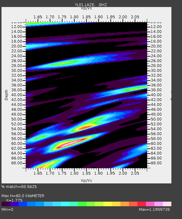
LAZE YL.LAZE - Earthquake Result Viewer
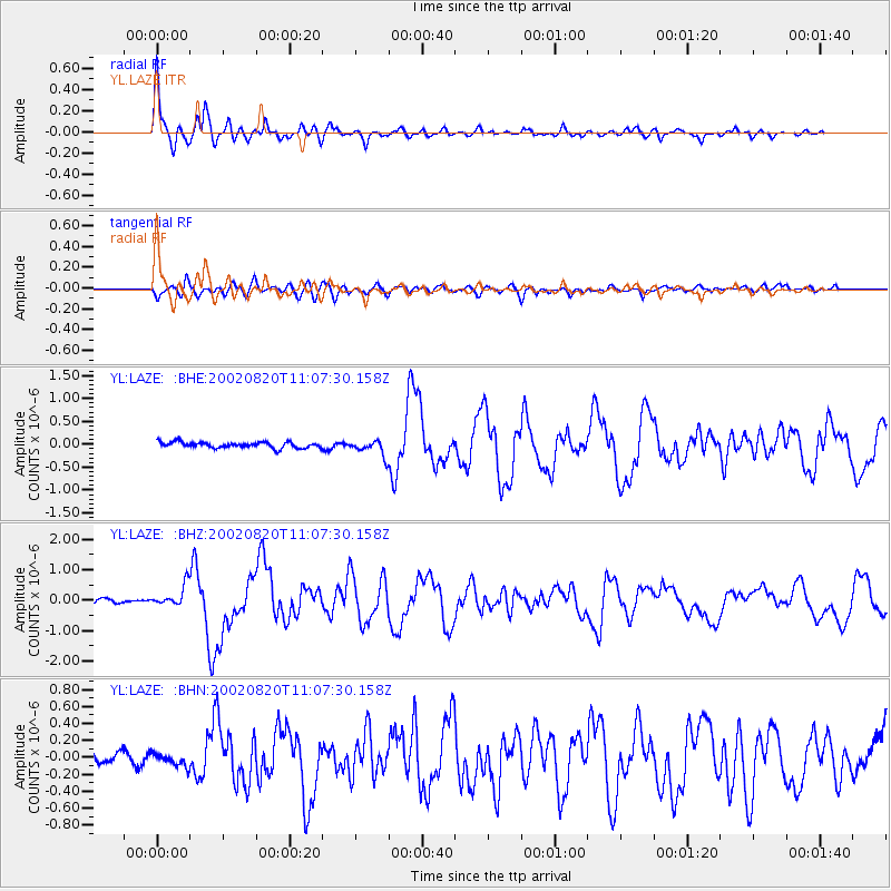
Earthquake location: Southeast Of Honshu, Japan
Earthquake latitude/longitude: 31.0/142.0
Earthquake time(UTC): 2002/08/20 (232) 10:59:32 GMT
Earthquake Depth: 9.0 km
Earthquake Magnitude: 5.4 MB, 6.2 MS, 6.3 MW, 6.1 MW
Earthquake Catalog/Contributor: WHDF/NEIC
Network: YL Himalayan Nepal Tibet Experiment
Station: LAZE YL.LAZE
Lat/Lon: 29.14 N/87.59 E
Elevation: 4011 m
Distance: 46.7 deg
Az: 282.298 deg
Baz: 73.573 deg
Ray Param: 0.07048382
Estimated Moho Depth: 60.0 km
Estimated Crust Vp/Vs: 1.77
Assumed Crust Vp: 6.514 km/s
Estimated Crust Vs: 3.67 km/s
Estimated Crust Poisson's Ratio: 0.27
Radial Match: 88.5625 %
Radial Bump: 376
Transverse Match: 68.9848 %
Transverse Bump: 400
SOD ConfigId: 16844
Insert Time: 2010-02-26 15:58:42.128 +0000
GWidth: 2.5
Max Bumps: 400
Tol: 0.001

Signal To Noise

ChannelStoNSTALTA
YL:LAZE: :BHZ:20020820T11:07:30.158Z5.53783.4483526E-76.226936E-8
YL:LAZE: :BHN:20020820T11:07:30.158Z0.755816.8852195E-89.109723E-8
YL:LAZE: :BHE:20020820T11:07:30.158Z2.6211561.685427E-76.4300906E-8
Arrivals
Ps7.6 SECOND
PpPs24 SECOND
PsPs/PpSs32 SECOND