You are here: Home > Network List > YL01 - Himalayan Nepal Tibet Experiment Stations List
> Station LAZE YL.LAZE > Earthquake Result Viewer
LAZE YL.LAZE - Earthquake Result Viewer
| Earthquake location: |
Northeastern China |
| Earthquake latitude/longitude: |
44.8/129.9 |
| Earthquake time(UTC): |
2002/09/15 (258) 08:39:32 GMT |
| Earthquake Depth: |
586 km |
| Earthquake Magnitude: |
5.8 MB, 6.4 MW, 6.4 MW |
| Earthquake Catalog/Contributor: |
WHDF/NEIC |
|
| Network: |
YL Himalayan Nepal Tibet Experiment |
| Station: |
LAZE YL.LAZE |
| Lat/Lon: |
29.14 N/87.59 E |
| Elevation: |
4011 m |
|
| Distance: |
36.8 deg |
| Az: |
259.45 deg |
| Baz: |
53.092 deg |
| Ray Param: |
0.073464595 |
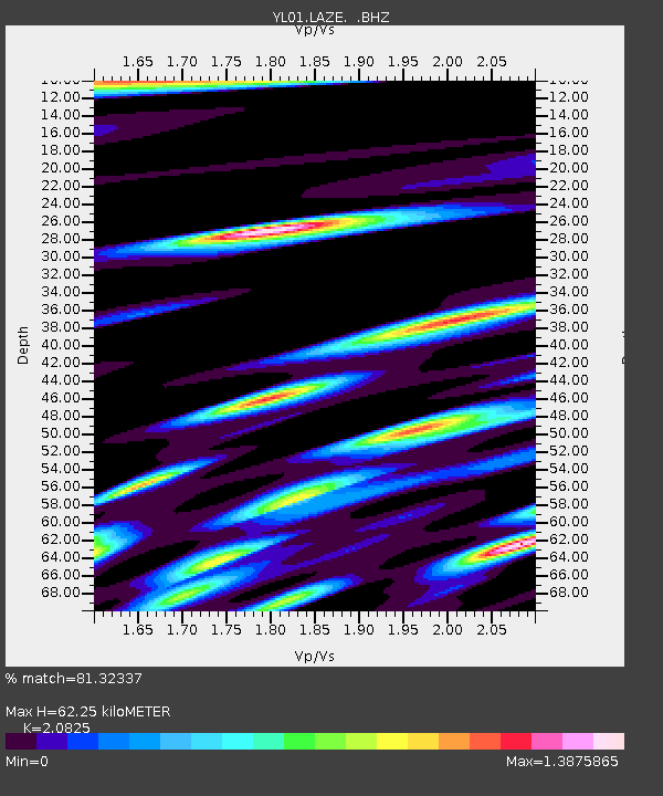
| Estimated Moho Depth: |
62.25 km |
| Estimated Crust Vp/Vs: |
2.08 |
| Assumed Crust Vp: |
6.514 km/s |
| Estimated Crust Vs: |
3.128 km/s |
| Estimated Crust Poisson's Ratio: |
0.35 |
|
| Radial Match: |
81.32337 % |
| Radial Bump: |
400 |
| Transverse Match: |
63.140057 % |
| Transverse Bump: |
400 |
| SOD ConfigId: |
16844 |
| Insert Time: |
2010-02-26 15:58:45.717 +0000 |
| GWidth: |
2.5 |
| Max Bumps: |
400 |
| Tol: |
0.001 |
|
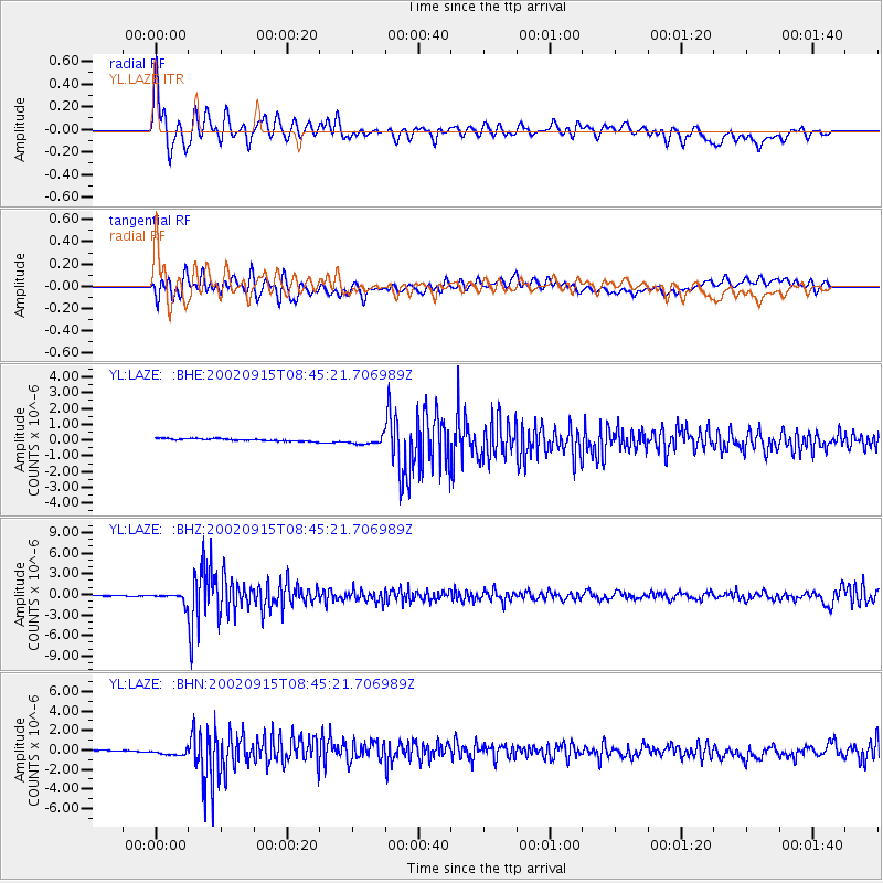
Signal To Noise
| Channel | StoN | STA | LTA |
| YL:LAZE: :BHZ:20020915T08:45:21.706989Z | 11.923132 | 6.4887075E-7 | 5.4421168E-8 |
| YL:LAZE: :BHN:20020915T08:45:21.706989Z | 0.79745704 | 2.2776825E-7 | 2.8561823E-7 |
| YL:LAZE: :BHE:20020915T08:45:21.706989Z | 3.3451047 | 2.6002806E-7 | 7.773391E-8 |
| Arrivals |
| Ps | 11 SECOND |
| PpPs | 28 SECOND |
| PsPs/PpSs | 39 SECOND |


