You are here: Home > Network List > YL01 - Himalayan Nepal Tibet Experiment Stations List
> Station LAZE YL.LAZE > Earthquake Result Viewer
LAZE YL.LAZE - Earthquake Result Viewer

| Earthquake location: |
Bali Sea |
| Earthquake latitude/longitude: |
-7.5/115.7 |
| Earthquake time(UTC): |
2002/10/03 (276) 19:05:10 GMT |
| Earthquake Depth: |
316 km |
| Earthquake Magnitude: |
6.0 MB, 6.0 MW, 6.0 MW |
| Earthquake Catalog/Contributor: |
WHDF/NEIC |
|
| Network: |
YL Himalayan Nepal Tibet Experiment |
| Station: |
LAZE YL.LAZE |
| Lat/Lon: |
29.14 N/87.59 E |
| Elevation: |
4011 m |
|
| Distance: |
45.4 deg |
| Az: |
324.671 deg |
| Baz: |
139.05 deg |
| Ray Param: |
0.07000007 |
| Estimated Moho Depth: |
43.5 km |
| Estimated Crust Vp/Vs: |
1.71 |
| Assumed Crust Vp: |
6.514 km/s |
| Estimated Crust Vs: |
3.815 km/s |
| Estimated Crust Poisson's Ratio: |
0.24 |
|
| Radial Match: |
87.10218 % |
| Radial Bump: |
400 |
| Transverse Match: |
82.15887 % |
| Transverse Bump: |
400 |
| SOD ConfigId: |
16844 |
| Insert Time: |
2010-02-26 15:58:47.875 +0000 |
| GWidth: |
2.5 |
| Max Bumps: |
400 |
| Tol: |
0.001 |
|
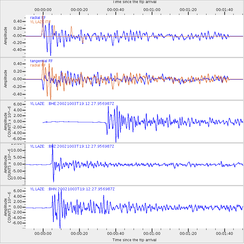
Signal To Noise
| Channel | StoN | STA | LTA |
| YL:LAZE: :BHZ:20021003T19:12:27.956987Z | 9.032727 | 4.8016267E-7 | 5.3158104E-8 |
| YL:LAZE: :BHN:20021003T19:12:27.956987Z | 0.91147053 | 2.1655238E-7 | 2.3758572E-7 |
| YL:LAZE: :BHE:20021003T19:12:27.956987Z | 2.6216412 | 2.1821778E-7 | 8.323708E-8 |
| Arrivals |
| Ps | 5.0 SECOND |
| PpPs | 17 SECOND |
| PsPs/PpSs | 22 SECOND |


