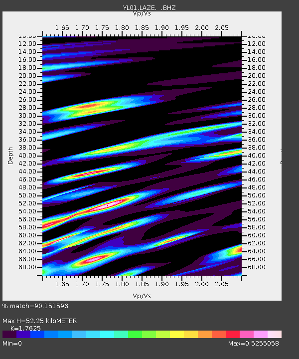
LAZE YL.LAZE - Earthquake Result Viewer

Earthquake location: Irian Jaya Region, Indonesia
Earthquake latitude/longitude: -1.8/134.3
Earthquake time(UTC): 2002/10/10 (283) 10:50:20 GMT
Earthquake Depth: 10 km
Earthquake Magnitude: 6.5 MB, 7.7 MS, 7.6 MW, 7.4 MW
Earthquake Catalog/Contributor: WHDF/NEIC
Network: YL Himalayan Nepal Tibet Experiment
Station: LAZE YL.LAZE
Lat/Lon: 29.14 N/87.59 E
Elevation: 4011 m
Distance: 54.2 deg
Az: 308.281 deg
Baz: 116.247 deg
Ray Param: 0.065593034
Estimated Moho Depth: 52.25 km
Estimated Crust Vp/Vs: 1.76
Assumed Crust Vp: 6.514 km/s
Estimated Crust Vs: 3.696 km/s
Estimated Crust Poisson's Ratio: 0.26
Radial Match: 90.151596 %
Radial Bump: 400
Transverse Match: 90.24558 %
Transverse Bump: 400
SOD ConfigId: 16844
Insert Time: 2010-02-26 15:58:50.409 +0000
GWidth: 2.5
Max Bumps: 400
Tol: 0.001

Signal To Noise

ChannelStoNSTALTA
YL:LAZE: :BHZ:20021010T10:59:15.208Z10.4970181.2632328E-61.2034207E-7
YL:LAZE: :BHN:20021010T10:59:15.208Z0.311805551.16924866E-73.749929E-7
YL:LAZE: :BHE:20021010T10:59:15.208Z3.68385586.104392E-71.657066E-7
Arrivals
Ps6.5 SECOND
PpPs21 SECOND
PsPs/PpSs27 SECOND