You are here: Home > Network List > YL01 - Himalayan Nepal Tibet Experiment Stations List
> Station LAZE YL.LAZE > Earthquake Result Viewer
LAZE YL.LAZE - Earthquake Result Viewer
| Earthquake location: |
Hokkaido, Japan Region |
| Earthquake latitude/longitude: |
41.2/142.2 |
| Earthquake time(UTC): |
2002/10/14 (287) 14:12:43 GMT |
| Earthquake Depth: |
61 km |
| Earthquake Magnitude: |
5.9 MB, 6.1 MW, 6.1 MW |
| Earthquake Catalog/Contributor: |
WHDF/NEIC |
|
| Network: |
YL Himalayan Nepal Tibet Experiment |
| Station: |
LAZE YL.LAZE |
| Lat/Lon: |
29.14 N/87.59 E |
| Elevation: |
4011 m |
|
| Distance: |
45.6 deg |
| Az: |
272.714 deg |
| Baz: |
59.537 deg |
| Ray Param: |
0.07099429 |
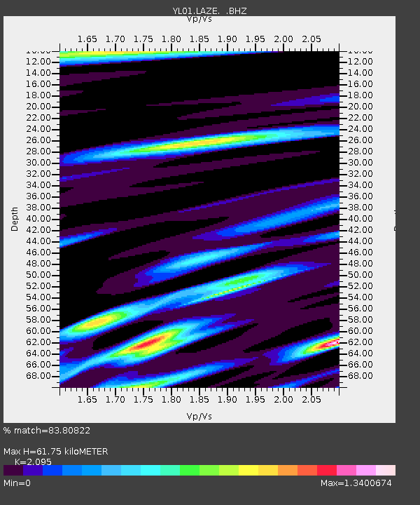
| Estimated Moho Depth: |
61.75 km |
| Estimated Crust Vp/Vs: |
2.10 |
| Assumed Crust Vp: |
6.514 km/s |
| Estimated Crust Vs: |
3.109 km/s |
| Estimated Crust Poisson's Ratio: |
0.35 |
|
| Radial Match: |
83.80822 % |
| Radial Bump: |
400 |
| Transverse Match: |
76.29373 % |
| Transverse Bump: |
400 |
| SOD ConfigId: |
16844 |
| Insert Time: |
2010-02-26 15:58:51.814 +0000 |
| GWidth: |
2.5 |
| Max Bumps: |
400 |
| Tol: |
0.001 |
|

Signal To Noise
| Channel | StoN | STA | LTA |
| YL:LAZE: :BHZ:20021014T14:20:27.306Z | 15.479021 | 1.3733645E-6 | 8.872425E-8 |
| YL:LAZE: :BHN:20021014T14:20:27.306Z | 6.2856765 | 4.194899E-7 | 6.6737435E-8 |
| YL:LAZE: :BHE:20021014T14:20:27.306Z | 3.3392632 | 4.2541603E-7 | 1.2739817E-7 |
| Arrivals |
| Ps | 11 SECOND |
| PpPs | 28 SECOND |
| PsPs/PpSs | 39 SECOND |


