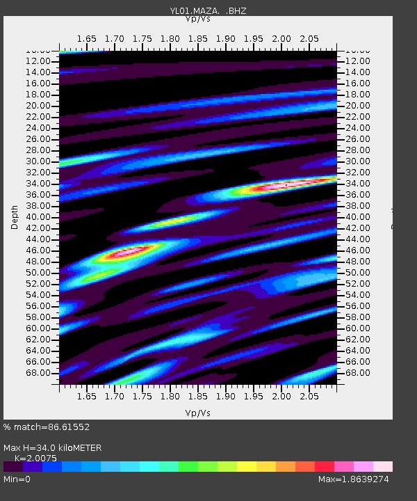
MAZA YL.MAZA - Earthquake Result Viewer
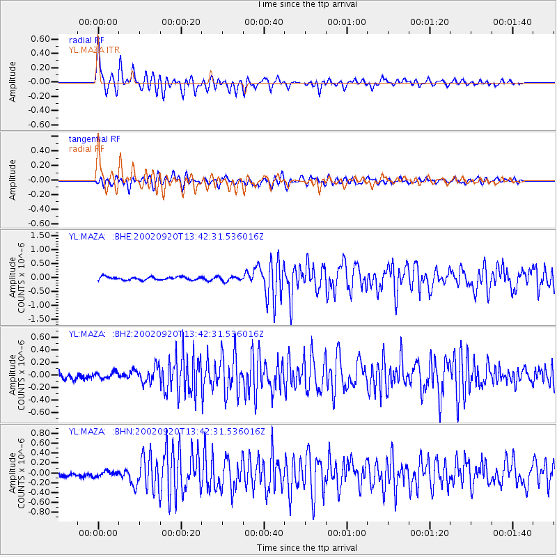
Earthquake location: Irian Jaya Region, Indonesia
Earthquake latitude/longitude: -1.7/134.0
Earthquake time(UTC): 2002/09/20 (263) 13:33:41 GMT
Earthquake Depth: 10 km
Earthquake Magnitude: 5.7 MB, 5.9 MS, 6.0 MW, 6.0 MW
Earthquake Catalog/Contributor: WHDF/NEIC
Network: YL Himalayan Nepal Tibet Experiment
Station: MAZA YL.MAZA
Lat/Lon: 28.67 N/87.86 E
Elevation: 4367 m
Distance: 53.6 deg
Az: 308.017 deg
Baz: 116.346 deg
Ray Param: 0.06601824
Estimated Moho Depth: 34.0 km
Estimated Crust Vp/Vs: 2.01
Assumed Crust Vp: 6.514 km/s
Estimated Crust Vs: 3.245 km/s
Estimated Crust Poisson's Ratio: 0.33
Radial Match: 86.61552 %
Radial Bump: 400
Transverse Match: 73.52121 %
Transverse Bump: 400
SOD ConfigId: 16820
Insert Time: 2010-02-26 15:59:14.009 +0000
GWidth: 2.5
Max Bumps: 400
Tol: 0.001

Signal To Noise

ChannelStoNSTALTA
YL:MAZA: :BHZ:20020920T13:42:31.536016Z0.959028244.8909584E-85.099911E-8
YL:MAZA: :BHN:20020920T13:42:31.536016Z1.08551164.933597E-84.5449514E-8
YL:MAZA: :BHE:20020920T13:42:31.536016Z1.40989797.7121165E-85.469982E-8
Arrivals
Ps5.5 SECOND
PpPs15 SECOND
PsPs/PpSs20 SECOND