
Station YL MAZA - YL.MAZA
Network: YL01 - Himalayan Nepal Tibet Experiment
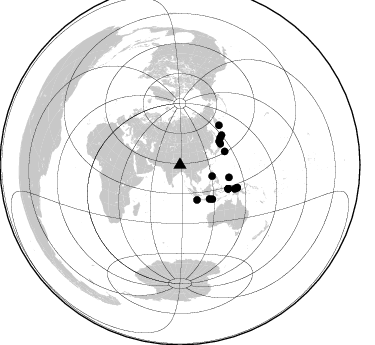
Nearby stations (2 deg radius)
| Station | Name | (Lat, Lon) | Start / End | Elevation |
| MAZA | YL.MAZA | (28.67, 87.86) | 2001-09-07 / 2003-01-01 | 4367 m |
| Crust2 Type: | RD,orogen/70km Tibet, no seds. |
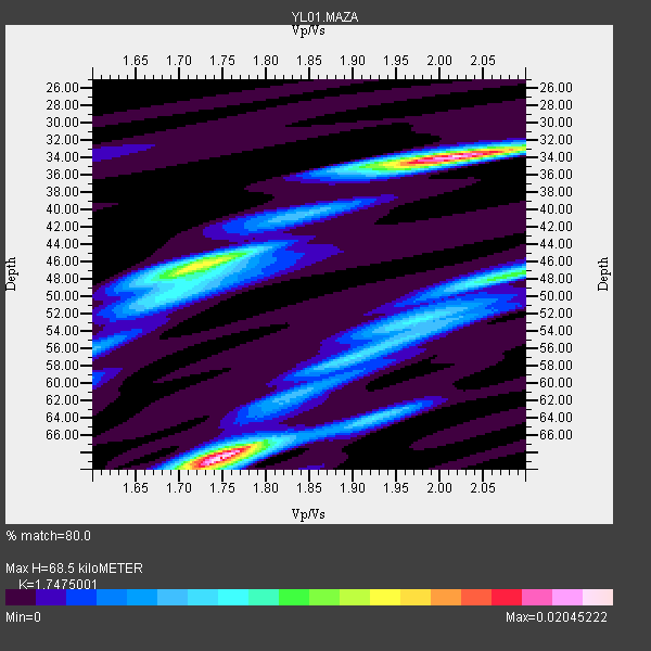
| Thickness Estimate: | 68 km |
| Thickness StdDev: | 15 km |
| Vp/Vs Estimate: | 1.75 |
| Vp/Vs StdDev: | 0.15 |
| Vs Estimate: | 3.728 km/s |
| Poisson's Ratio: | 0.26 |
| Peak Value: | 0.02 |
| Assumed Vp: | 6.514 km/s |
| Ps Weight: | 0.33333334 |
| PpPs Weight: | 0.33333334 |
| PsPs Weight: | 0.33333328 |
| Residual Complexity: | 0.814 |
| Nearby stations H: | +- |
| (2.0 deg) Vp/Vs: | +- |
8 with match > 90% ( 23.529411 %) and 17 with match > 80% ( 50.0 %) out of 34.
Download stack as xyz text file.
Azimuth Distribution of Events:
Prior Results for this Station
| Study | Thickness | Vp/Vs | Vp | Vs | Poissons Ratio | Extra |
| EARS | 68 km | 1.75 | 6.514 km/s | 3.728 km/s | 0.26 | |
| Crust2.0 | 70 km | 1.76 | 6.514 km/s | 3.706 km/s | 0.26 | RD,orogen/70km Tibet, no seds. |
| Global Maxima | 68 km | 1.75 | 6.514 km/s | 3.728 km/s | 0.26 | amp=0.02045222 |
| Local Maxima 1 | 34 km | 2.02 | 6.514 km/s | 3.225 km/s | 0.34 | amp=0.02001996 |
| Local Maxima 2 | 47 km | 1.71 | 6.514 km/s | 3.804 km/s | 0.24 | amp=0.012619384 |
| Local Maxima 3 | 48 km | 2.08 | 6.514 km/s | 3.132 km/s | 0.35 | amp=0.009349885 |
| Local Maxima 4 | 53 km | 1.96 | 6.514 km/s | 3.324 km/s | 0.32 | amp=0.0050300607 |
| Predicted Arrivals for vertical incidence (zero ray parameter) | |
| Ps | 7.86 SECOND |
| PpPs | 28.89 SECOND |
| PsPs/PpSs | 36.75 SECOND |
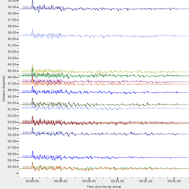
Events Processed for this Station
Download zip of receiver functions as SAC
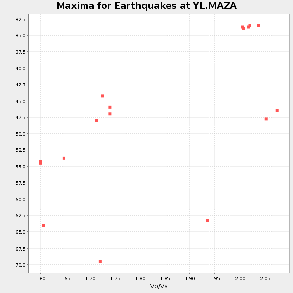
Plot maxima for each earthquake.
Events Used in the Stack
(17 events)| Radial Match | Distance | Baz | FERegion | Time | Lat/Lon | Depth | Magnitude |
| 95.90731 | 47.0 deg | 136.631 deg | Sumbawa Region, Indonesia | 2002/10/06 15:46:33 GMT | (-8.2, 118.3) | 10 km | 5.8 MB, 6.0 MS, 6.2 MW, 6.2 MW |
| 93.57437 | 53.7 deg | 116.116 deg | Irian Jaya Region, Indonesia | 2002/09/20 15:43:35 GMT | (-1.7, 134.2) | 10 km | 5.9 MB, 6.4 MS, 6.4 MW, 6.3 MW |
| 93.06268 | 34.0 deg | 109.339 deg | Mindoro, Philippines | 2002/09/03 14:23:45 GMT | (13.5, 120.8) | 10 km | 5.5 MB, 5.4 MS, 5.9 MW, 5.8 MW |
| 92.412544 | 59.6 deg | 113.617 deg | Irian Jaya, Indonesia | 2002/10/17 17:52:44 GMT | (-3.6, 140.2) | 33 km | 5.6 MB, 6.2 MS, 6.3 MW, 6.3 MW |
| 92.017525 | 61.5 deg | 111.628 deg | Near N Coast Of New Guinea, P.N.G. | 2002/09/17 11:20:23 GMT | (-3.3, 142.8) | 10 km | 5.7 MB, 5.9 MS, 6.1 MW, 6.0 MW |
| 91.46004 | 61.4 deg | 111.714 deg | Near N Coast Of New Guinea, P.N.G. | 2002/09/16 13:23:00 GMT | (-3.3, 142.7) | 10 km | 5.9 MB, 5.9 MS, 6.3 MW, 6.1 MW |
| 91.324715 | 51.1 deg | 54.587 deg | Kuril Islands | 2002/10/19 12:09:05 GMT | (44.3, 150.0) | 33 km | 5.4 MB, 6.2 MS, 6.4 MW, 6.1 MW |
| 90.52995 | 50.5 deg | 104.335 deg | W. Caroline Islands, Micronesia | 2002/08/14 13:12:39 GMT | (7.8, 136.9) | 10 km | 6.1 MB, 6.0 MS, 6.3 MW, 6.3 MW |
| 89.40668 | 48.4 deg | 56.355 deg | Kuril Islands | 2002/08/24 18:40:53 GMT | (43.1, 146.1) | 43 km | 5.9 MB, 5.8 MS, 6.2 MW, 6.1 MW |
| 89.168274 | 55.6 deg | 44.654 deg | Near East Coast Of Kamchatka | 2002/10/16 10:12:21 GMT | (52.0, 157.3) | 102 km | 6.1 MB, 6.2 MW, 6.2 MW |
| 88.53044 | 45.5 deg | 62.365 deg | Near East Coast Of Honshu, Japan | 2002/11/03 03:37:42 GMT | (38.9, 142.0) | 39 km | 5.7 MB, 6.1 MS, 6.4 MW, 6.4 MW |
| 88.39809 | 44.9 deg | 139.045 deg | Bali Sea | 2002/10/03 19:05:10 GMT | (-7.5, 115.7) | 316 km | 6.0 MB, 6.0 MW, 6.0 MW |
| 86.61552 | 53.6 deg | 116.346 deg | Irian Jaya Region, Indonesia | 2002/09/20 13:33:41 GMT | (-1.7, 134.0) | 10 km | 5.7 MB, 5.9 MS, 6.0 MW, 6.0 MW |
| 86.51852 | 53.8 deg | 116.143 deg | Irian Jaya Region, Indonesia | 2002/10/10 10:50:20 GMT | (-1.8, 134.3) | 10 km | 6.5 MB, 7.7 MS, 7.6 MW, 7.4 MW |
| 85.94384 | 45.6 deg | 59.155 deg | Hokkaido, Japan Region | 2002/10/14 14:12:43 GMT | (41.2, 142.2) | 61 km | 5.9 MB, 6.1 MW, 6.1 MW |
| 84.03641 | 46.6 deg | 73.215 deg | Southeast Of Honshu, Japan | 2002/08/20 10:59:32 GMT | (31.0, 142.0) | 9.0 km | 5.4 MB, 6.2 MS, 6.3 MW, 6.1 MW |
| 82.277145 | 38.7 deg | 153.798 deg | Sunda Strait, Indonesia | 2002/08/13 06:05:37 GMT | (-7.0, 104.0) | 33 km | 5.9 MS, 5.4 MB, 5.7 MW, 5.7 MW |
Losers
(17 events)| Radial Match | Distance | Baz | FERegion | Time | Lat/Lon | Depth | Magnitude | Reason |
| 78.55257 | 64.0 deg | 252.15 deg | Lake Tanganyika Region | 2002/10/24 06:08:37 GMT | (-1.9, 29.0) | 11 km | 5.9 MB, 6.3 MS, 6.2 MW, 6.1 MW | |
| 78.462814 | 30.8 deg | 88.367 deg | Taiwan Region | 2002/09/16 00:03:29 GMT | (25.2, 122.3) | 183 km | 5.6 MW, 5.3 MB, 5.5 MW | |
| 77.89595 | 39.2 deg | 151.203 deg | Sunda Strait, Indonesia | 2002/08/26 14:55:13 GMT | (-6.8, 105.7) | 63 km | 5.6 MB, 5.8 MW, 5.7 MW | |
| 76.27469 | 70.4 deg | 179.586 deg | Southeast Indian Ridge | 2002/10/08 01:23:58 GMT | (-42.0, 88.4) | 10 km | 5.3 MB, 5.7 MS, 6.0 MW, 5.9 MW | |
| 75.69976 | 36.2 deg | 254.346 deg | Eastern Gulf Of Aden | 2002/09/01 17:14:59 GMT | (14.3, 51.9) | 10 km | 5.8 MS, 5.2 MB, 6.0 MW, 6.0 MW | |
| 75.23128 | 59.7 deg | 113.623 deg | Irian Jaya, Indonesia | 2002/10/19 00:43:56 GMT | (-3.7, 140.3) | 33 km | 5.3 MB, 5.9 MS, 6.1 MW, 6.0 MW | |
| 75.21395 | 36.9 deg | 52.536 deg | Northeastern China | 2002/09/15 08:39:32 GMT | (44.8, 129.9) | 586 km | 5.8 MB, 6.4 MW, 6.4 MW | |
| 74.14543 | 31.4 deg | 108.965 deg | Philippine Islands Region | 2002/10/12 23:43:12 GMT | (15.1, 118.5) | 33 km | 5.6 MB, 5.6 MS, 6.1 MW | |
| 71.508224 | 53.5 deg | 116.013 deg | Irian Jaya Region, Indonesia | 2002/10/10 21:19:58 GMT | (-1.5, 134.1) | 10 km | 5.8 MB, 5.7 MS, 6.0 MW | |
| 70.298676 | 91.8 deg | 111.154 deg | Vanuatu Islands | 2002/08/12 02:59:24 GMT | (-19.5, 169.0) | 112 km | 5.6 MB, 6.0 MW, 5.9 MW | |
| 67.31778 | 80.8 deg | 107.433 deg | Solomon Islands | 2002/09/24 23:01:28 GMT | (-10.6, 161.2) | 19 km | 5.7 MB, 6.5 MS, 6.3 MW, 6.3 MW | |
| 65.92684 | 81.2 deg | 107.597 deg | Solomon Islands | 2002/10/03 04:26:06 GMT | (-11.0, 161.4) | 10 km | 5.6 MB, 5.6 MS, 5.9 MW, 5.7 MW | |
| 62.496593 | 91.6 deg | 110.342 deg | Vanuatu Islands | 2002/10/07 19:00:31 GMT | (-18.7, 169.3) | 246 km | 5.4 MB, 5.7 MW, 5.6 MW | |
| 58.060375 | 53.7 deg | 116.155 deg | Irian Jaya Region, Indonesia | 2002/10/10 11:05:15 GMT | (-1.7, 134.2) | 10 km | 5.5 MB | |
| 57.399784 | 53.8 deg | 123.787 deg | Banda Sea | 2002/07/30 20:02:06 GMT | (-6.5, 130.3) | 103 km | 5.5 MW, 5.4 MB, 5.3 MW | |
| 51.101597 | 80.9 deg | 107.681 deg | Solomon Islands | 2002/10/01 08:46:55 GMT | (-10.9, 161.2) | 10 km | 5.7 MB, 5.5 MS, 5.8 MW, 5.6 MW | |
| 35.403484 | 70.0 deg | 336.279 deg | Iceland Region | 2002/09/16 18:48:26 GMT | (66.9, -18.5) | 10 km | 5.5 MB, 5.7 MS, 5.8 MW, 5.8 MW |
