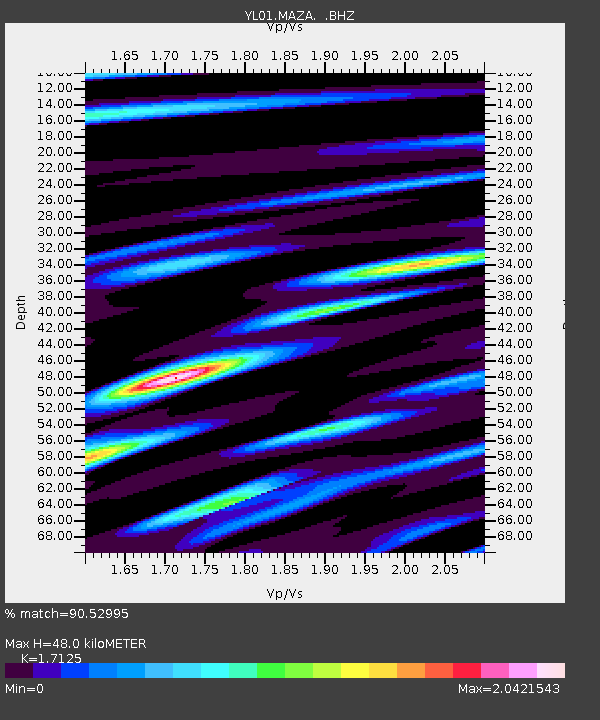
MAZA YL.MAZA - Earthquake Result Viewer
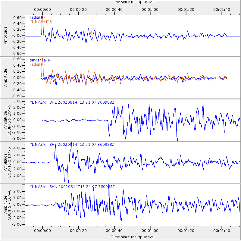
Earthquake location: W. Caroline Islands, Micronesia
Earthquake latitude/longitude: 7.8/136.9
Earthquake time(UTC): 2002/08/14 (226) 13:12:39 GMT
Earthquake Depth: 10 km
Earthquake Magnitude: 6.1 MB, 6.0 MS, 6.3 MW, 6.3 MW
Earthquake Catalog/Contributor: WHDF/NEIC
Network: YL Himalayan Nepal Tibet Experiment
Station: MAZA YL.MAZA
Lat/Lon: 28.67 N/87.86 E
Elevation: 4367 m
Distance: 50.5 deg
Az: 300.764 deg
Baz: 104.335 deg
Ray Param: 0.06798778
Estimated Moho Depth: 48.0 km
Estimated Crust Vp/Vs: 1.71
Assumed Crust Vp: 6.514 km/s
Estimated Crust Vs: 3.804 km/s
Estimated Crust Poisson's Ratio: 0.24
Radial Match: 90.52995 %
Radial Bump: 400
Transverse Match: 86.93794 %
Transverse Bump: 400
SOD ConfigId: 16844
Insert Time: 2010-02-26 15:59:19.262 +0000
GWidth: 2.5
Max Bumps: 400
Tol: 0.001

Signal To Noise

ChannelStoNSTALTA
YL:MAZA: :BHZ:20020814T13:21:07.360988Z1.22605511.3171983E-71.07433856E-7
YL:MAZA: :BHN:20020814T13:21:07.360988Z1.03083527.900734E-87.6644014E-8
YL:MAZA: :BHE:20020814T13:21:07.360988Z0.67128776.114522E-89.108646E-8
Arrivals
Ps5.6 SECOND
PpPs19 SECOND
PsPs/PpSs24 SECOND