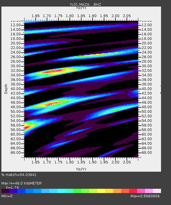
MAZA YL.MAZA - Earthquake Result Viewer

Earthquake location: Southeast Of Honshu, Japan
Earthquake latitude/longitude: 31.0/142.0
Earthquake time(UTC): 2002/08/20 (232) 10:59:32 GMT
Earthquake Depth: 9.0 km
Earthquake Magnitude: 5.4 MB, 6.2 MS, 6.3 MW, 6.1 MW
Earthquake Catalog/Contributor: WHDF/NEIC
Network: YL Himalayan Nepal Tibet Experiment
Station: MAZA YL.MAZA
Lat/Lon: 28.67 N/87.86 E
Elevation: 4367 m
Distance: 46.6 deg
Az: 281.591 deg
Baz: 73.215 deg
Ray Param: 0.07053828
Estimated Moho Depth: 46.0 km
Estimated Crust Vp/Vs: 1.74
Assumed Crust Vp: 6.514 km/s
Estimated Crust Vs: 3.744 km/s
Estimated Crust Poisson's Ratio: 0.25
Radial Match: 84.03641 %
Radial Bump: 400
Transverse Match: 67.230644 %
Transverse Bump: 400
SOD ConfigId: 16844
Insert Time: 2010-02-26 15:59:20.374 +0000
GWidth: 2.5
Max Bumps: 400
Tol: 0.001

Signal To Noise

ChannelStoNSTALTA
YL:MAZA: :BHZ:20020820T11:07:29.461986Z2.90695122.7899756E-79.5976E-8
YL:MAZA: :BHN:20020820T11:07:29.461986Z1.90473991.19190524E-76.257575E-8
YL:MAZA: :BHE:20020820T11:07:29.461986Z2.47682551.8395004E-77.426847E-8
Arrivals
Ps5.6 SECOND
PpPs18 SECOND
PsPs/PpSs24 SECOND