You are here: Home > Network List > YL01 - Himalayan Nepal Tibet Experiment Stations List
> Station MAZA YL.MAZA > Earthquake Result Viewer
MAZA YL.MAZA - Earthquake Result Viewer

| Earthquake location: |
Bali Sea |
| Earthquake latitude/longitude: |
-7.5/115.7 |
| Earthquake time(UTC): |
2002/10/03 (276) 19:05:10 GMT |
| Earthquake Depth: |
316 km |
| Earthquake Magnitude: |
6.0 MB, 6.0 MW, 6.0 MW |
| Earthquake Catalog/Contributor: |
WHDF/NEIC |
|
| Network: |
YL Himalayan Nepal Tibet Experiment |
| Station: |
MAZA YL.MAZA |
| Lat/Lon: |
28.67 N/87.86 E |
| Elevation: |
4367 m |
|
| Distance: |
44.9 deg |
| Az: |
324.485 deg |
| Baz: |
139.045 deg |
| Ray Param: |
0.07032617 |
| Estimated Moho Depth: |
63.25 km |
| Estimated Crust Vp/Vs: |
1.93 |
| Assumed Crust Vp: |
6.514 km/s |
| Estimated Crust Vs: |
3.367 km/s |
| Estimated Crust Poisson's Ratio: |
0.32 |
|
| Radial Match: |
88.39809 % |
| Radial Bump: |
400 |
| Transverse Match: |
84.306305 % |
| Transverse Bump: |
400 |
| SOD ConfigId: |
16844 |
| Insert Time: |
2010-02-26 15:59:24.362 +0000 |
| GWidth: |
2.5 |
| Max Bumps: |
400 |
| Tol: |
0.001 |
|
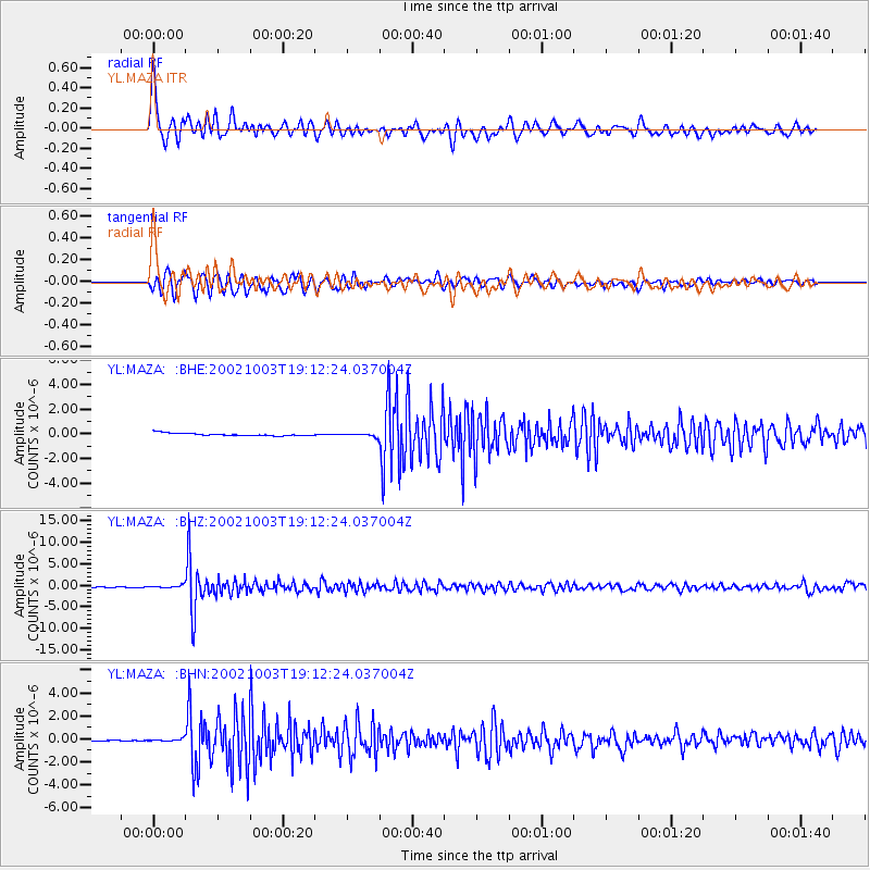
Signal To Noise
| Channel | StoN | STA | LTA |
| YL:MAZA: :BHZ:20021003T19:12:24.037004Z | 6.6514263 | 3.0314573E-7 | 4.5576044E-8 |
| YL:MAZA: :BHN:20021003T19:12:24.037004Z | 2.5718353 | 9.200739E-8 | 3.5774995E-8 |
| YL:MAZA: :BHE:20021003T19:12:24.037004Z | 1.2043027 | 1.3108861E-7 | 1.08850216E-7 |
| Arrivals |
| Ps | 9.6 SECOND |
| PpPs | 27 SECOND |
| PsPs/PpSs | 37 SECOND |


