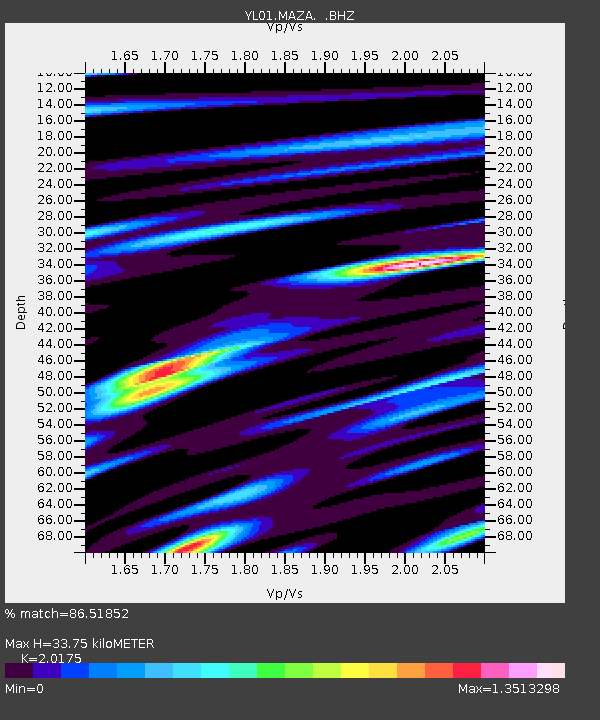
MAZA YL.MAZA - Earthquake Result Viewer
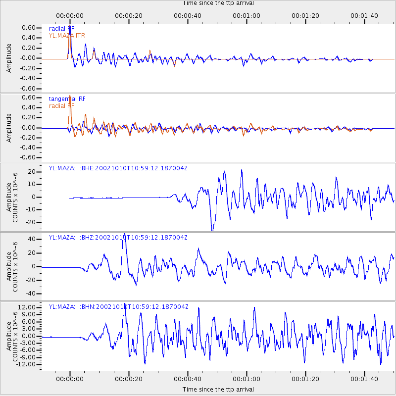
Earthquake location: Irian Jaya Region, Indonesia
Earthquake latitude/longitude: -1.8/134.3
Earthquake time(UTC): 2002/10/10 (283) 10:50:20 GMT
Earthquake Depth: 10 km
Earthquake Magnitude: 6.5 MB, 7.7 MS, 7.6 MW, 7.4 MW
Earthquake Catalog/Contributor: WHDF/NEIC
Network: YL Himalayan Nepal Tibet Experiment
Station: MAZA YL.MAZA
Lat/Lon: 28.67 N/87.86 E
Elevation: 4367 m
Distance: 53.8 deg
Az: 307.888 deg
Baz: 116.143 deg
Ray Param: 0.06586241
Estimated Moho Depth: 33.75 km
Estimated Crust Vp/Vs: 2.02
Assumed Crust Vp: 6.514 km/s
Estimated Crust Vs: 3.229 km/s
Estimated Crust Poisson's Ratio: 0.34
Radial Match: 86.51852 %
Radial Bump: 400
Transverse Match: 76.847786 %
Transverse Bump: 400
SOD ConfigId: 16844
Insert Time: 2010-02-26 15:59:25.682 +0000
GWidth: 2.5
Max Bumps: 400
Tol: 0.001

Signal To Noise

ChannelStoNSTALTA
YL:MAZA: :BHZ:20021010T10:59:12.187004Z10.7732921.1688782E-61.0849778E-7
YL:MAZA: :BHN:20021010T10:59:12.187004Z5.6949192.4989097E-74.3879634E-8
YL:MAZA: :BHE:20021010T10:59:12.187004Z8.2002995.789081E-77.059597E-8
Arrivals
Ps5.5 SECOND
PpPs15 SECOND
PsPs/PpSs20 SECOND