You are here: Home > Network List > YL01 - Himalayan Nepal Tibet Experiment Stations List
> Station MAZA YL.MAZA > Earthquake Result Viewer
MAZA YL.MAZA - Earthquake Result Viewer
| Earthquake location: |
Hokkaido, Japan Region |
| Earthquake latitude/longitude: |
41.2/142.2 |
| Earthquake time(UTC): |
2002/10/14 (287) 14:12:43 GMT |
| Earthquake Depth: |
61 km |
| Earthquake Magnitude: |
5.9 MB, 6.1 MW, 6.1 MW |
| Earthquake Catalog/Contributor: |
WHDF/NEIC |
|
| Network: |
YL Himalayan Nepal Tibet Experiment |
| Station: |
MAZA YL.MAZA |
| Lat/Lon: |
28.67 N/87.86 E |
| Elevation: |
4367 m |
|
| Distance: |
45.6 deg |
| Az: |
271.987 deg |
| Baz: |
59.155 deg |
| Ray Param: |
0.07096969 |
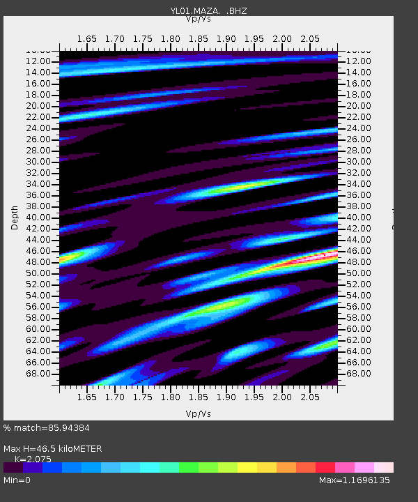
| Estimated Moho Depth: |
46.5 km |
| Estimated Crust Vp/Vs: |
2.08 |
| Assumed Crust Vp: |
6.514 km/s |
| Estimated Crust Vs: |
3.139 km/s |
| Estimated Crust Poisson's Ratio: |
0.35 |
|
| Radial Match: |
85.94384 % |
| Radial Bump: |
400 |
| Transverse Match: |
72.88292 % |
| Transverse Bump: |
400 |
| SOD ConfigId: |
16844 |
| Insert Time: |
2010-02-26 15:59:27.015 +0000 |
| GWidth: |
2.5 |
| Max Bumps: |
400 |
| Tol: |
0.001 |
|

Signal To Noise
| Channel | StoN | STA | LTA |
| YL:MAZA: :BHZ:20021014T14:20:27.612Z | 22.52086 | 1.4208393E-6 | 6.308992E-8 |
| YL:MAZA: :BHN:20021014T14:20:27.612Z | 11.672706 | 3.7648866E-7 | 3.225376E-8 |
| YL:MAZA: :BHE:20021014T14:20:27.612Z | 8.127815 | 5.4179895E-7 | 6.665985E-8 |
| Arrivals |
| Ps | 8.1 SECOND |
| PpPs | 21 SECOND |
| PsPs/PpSs | 29 SECOND |


