You are here: Home > Network List > YL01 - Himalayan Nepal Tibet Experiment Stations List
> Station MAZA YL.MAZA > Earthquake Result Viewer
MAZA YL.MAZA - Earthquake Result Viewer
| Earthquake location: |
Near East Coast Of Kamchatka |
| Earthquake latitude/longitude: |
52.0/157.3 |
| Earthquake time(UTC): |
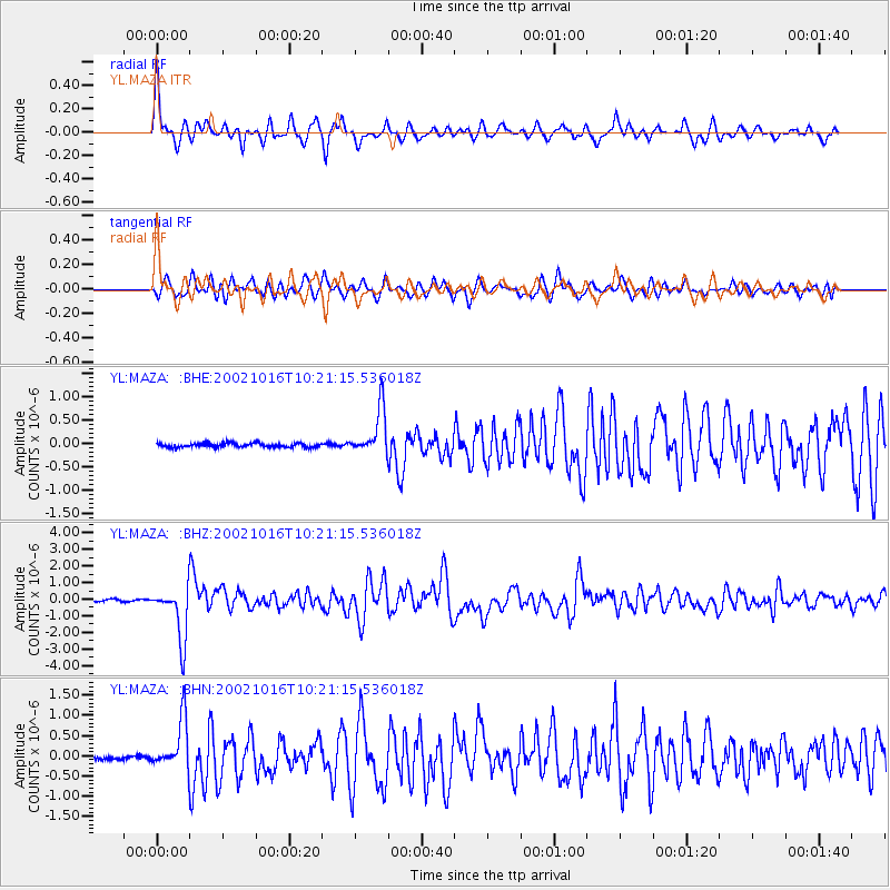
2002/10/16 (289) 10:12:21 GMT |
| Earthquake Depth: |
102 km |
| Earthquake Magnitude: |
6.1 MB, 6.2 MW, 6.2 MW |
| Earthquake Catalog/Contributor: |
WHDF/NEIC |
|
| Network: |
YL Himalayan Nepal Tibet Experiment |
| Station: |
MAZA YL.MAZA |
| Lat/Lon: |
28.67 N/87.86 E |
| Elevation: |
4367 m |
|
| Distance: |
55.6 deg |
| Az: |
273.707 deg |
| Baz: |
44.654 deg |
| Ray Param: |
0.064409 |
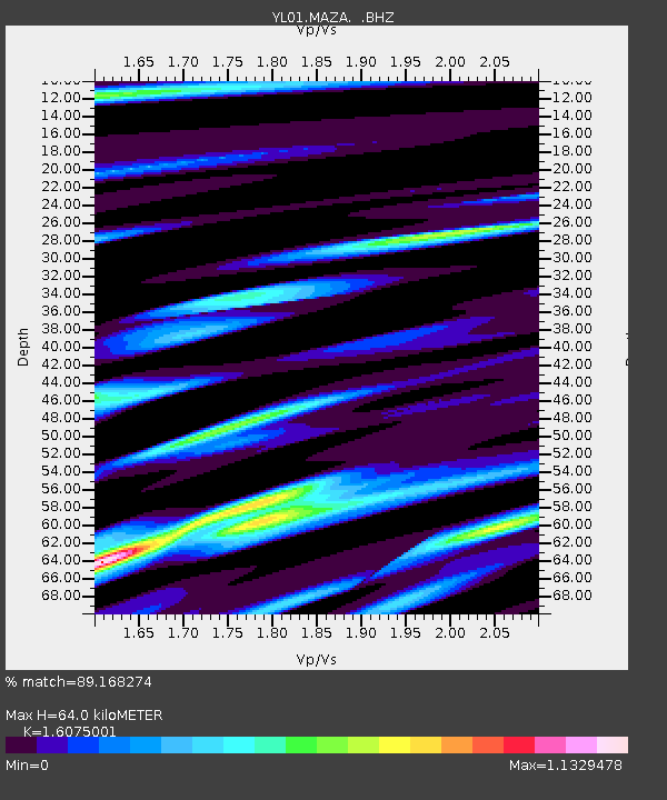
| Estimated Moho Depth: |
64.0 km |
| Estimated Crust Vp/Vs: |
1.61 |
| Assumed Crust Vp: |
6.514 km/s |
| Estimated Crust Vs: |
4.052 km/s |
| Estimated Crust Poisson's Ratio: |
0.18 |
|
| Radial Match: |
89.168274 % |
| Radial Bump: |
388 |
| Transverse Match: |
80.1343 % |
| Transverse Bump: |
400 |
| SOD ConfigId: |
16844 |
| Insert Time: |
2010-02-26 15:59:28.345 +0000 |
| GWidth: |
2.5 |
| Max Bumps: |
400 |
| Tol: |
0.001 |
|
Signal To Noise
| Channel | StoN | STA | LTA |
| YL:MAZA: :BHZ:20021016T10:21:15.536018Z | 26.437294 | 1.5962437E-6 | 6.037848E-8 |
| YL:MAZA: :BHN:20021016T10:21:15.536018Z | 14.723187 | 6.058902E-7 | 4.115211E-8 |
| YL:MAZA: :BHE:20021016T10:21:15.536018Z | 10.981197 | 4.906603E-7 | 4.4681858E-8 |
| Arrivals |
| Ps | 6.3 SECOND |
| PpPs | 24 SECOND |
| PsPs/PpSs | 30 SECOND |


