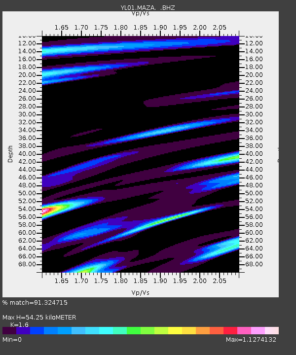
MAZA YL.MAZA - Earthquake Result Viewer

Earthquake location: Kuril Islands
Earthquake latitude/longitude: 44.3/150.0
Earthquake time(UTC): 2002/10/19 (292) 12:09:05 GMT
Earthquake Depth: 33 km
Earthquake Magnitude: 5.4 MB, 6.2 MS, 6.4 MW, 6.1 MW
Earthquake Catalog/Contributor: WHDF/NEIC
Network: YL Himalayan Nepal Tibet Experiment
Station: MAZA YL.MAZA
Lat/Lon: 28.67 N/87.86 E
Elevation: 4367 m
Distance: 51.1 deg
Az: 274.169 deg
Baz: 54.587 deg
Ray Param: 0.06753992
Estimated Moho Depth: 54.25 km
Estimated Crust Vp/Vs: 1.60
Assumed Crust Vp: 6.514 km/s
Estimated Crust Vs: 4.071 km/s
Estimated Crust Poisson's Ratio: 0.18
Radial Match: 91.324715 %
Radial Bump: 400
Transverse Match: 82.06765 %
Transverse Bump: 400
SOD ConfigId: 16844
Insert Time: 2010-02-26 15:59:29.699 +0000
GWidth: 2.5
Max Bumps: 400
Tol: 0.001

Signal To Noise

ChannelStoNSTALTA
YL:MAZA: :BHZ:20021019T12:17:34.463008Z11.3276855.002876E-74.4165034E-8
YL:MAZA: :BHN:20021019T12:17:34.463008Z2.9833731.2941115E-74.3377458E-8
YL:MAZA: :BHE:20021019T12:17:34.463008Z3.1217971.4648553E-74.6923464E-8
Arrivals
Ps5.3 SECOND
PpPs20 SECOND
PsPs/PpSs26 SECOND