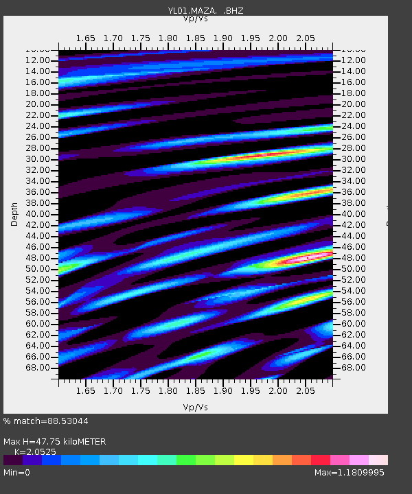
MAZA YL.MAZA - Earthquake Result Viewer

Earthquake location: Near East Coast Of Honshu, Japan
Earthquake latitude/longitude: 38.9/142.0
Earthquake time(UTC): 2002/11/03 (307) 03:37:42 GMT
Earthquake Depth: 39 km
Earthquake Magnitude: 5.7 MB, 6.1 MS, 6.4 MW, 6.4 MW
Earthquake Catalog/Contributor: WHDF/NEIC
Network: YL Himalayan Nepal Tibet Experiment
Station: MAZA YL.MAZA
Lat/Lon: 28.67 N/87.86 E
Elevation: 4367 m
Distance: 45.5 deg
Az: 274.059 deg
Baz: 62.365 deg
Ray Param: 0.07111687
Estimated Moho Depth: 47.75 km
Estimated Crust Vp/Vs: 2.05
Assumed Crust Vp: 6.514 km/s
Estimated Crust Vs: 3.174 km/s
Estimated Crust Poisson's Ratio: 0.34
Radial Match: 88.53044 %
Radial Bump: 400
Transverse Match: 81.71095 %
Transverse Bump: 400
SOD ConfigId: 16844
Insert Time: 2010-02-26 15:59:31.101 +0000
GWidth: 2.5
Max Bumps: 400
Tol: 0.001

Signal To Noise

ChannelStoNSTALTA
YL:MAZA: :BHZ:20021103T03:45:27.485985Z7.1258394.430132E-76.216997E-8
YL:MAZA: :BHN:20021103T03:45:27.485985Z2.31257962.203597E-79.528739E-8
YL:MAZA: :BHE:20021103T03:45:27.485985Z3.5057972.8640622E-78.169504E-8
Arrivals
Ps8.2 SECOND
PpPs21 SECOND
PsPs/PpSs29 SECOND